Report on Dempo (Indonesia) — March 2009
Bulletin of the Global Volcanism Network, vol. 34, no. 3 (March 2009)
Managing Editor: Richard Wunderman.
Dempo (Indonesia) Phreatic eruption in September 2006 sent mud 300 m
Please cite this report as:
Global Volcanism Program, 2009. Report on Dempo (Indonesia) (Wunderman, R., ed.). Bulletin of the Global Volcanism Network, 34:3. Smithsonian Institution. https://doi.org/10.5479/si.GVP.BGVN200903-261230
Dempo
Indonesia
4.016°S, 103.121°E; summit elev. 3142 m
All times are local (unless otherwise noted)
Our most recent report on Dempo (BGVN 34:01) discussed a phreatic eruption on 1 January 2009. This eruption prompted Indonesia's Center of Volcanology and Geological Hazard Mitigation (CVGHM) to raise the alert level from 1 (normal) to 2 (alert) on a scale of 1-4. A few months later, on 23 March 2009, the CVGHM lowered Dempo's Alert Level to 1, based on visual observations of the crater lake during 5-6 January and 2-4 March, and decreased seismicity since the 1 January phreatic eruption.
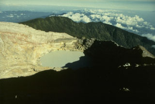
The name Dempo applies to both the larger complex and to a peak that sits adjacent to a neighboring peak called Marapi. The latter volcano name applies to several different volcanoes in Indonesia and is easily confused with the very prominent volcano Merapi (central Java). The Marapi cone in the Dempo complex contains a ~ 400 m diameter crater lake, the source of both the 2006 and 2009 eruptions.
The remainder of this report discusses the phreatic eruption that occurred in September 2006. This eruption had not been previously discussed in the Bulletin, and CVGHM reporting on the subject has recently come to our attention.
In the month before this eruption, teams from the CVGHM had visited several times. On 13 August 2006, a team prepared a map of Dempo and reported that the condition of the water in Marapi's crater lake was normal and clear or slightly blue in color, with no bubbling. On 4 September 2006, a team climbed to the peak of Dempo and reported that activity was normal other than some bubbling at the E edge of the crater lake.
2006 phreatic eruption. On 25 September 2006, a phreatic eruption occurred that expelled water from Marapi's crater lake and propelled mud onto the area around the peak up to a radius of 300 m.
On the next day, the inspector for Dempo, Mr. Mulyadi, accompanied by six friends, inspected the volcano and its lake. According to Mulyadi's team, the lake water was bubbling and had changed to a grayish color. Acrid sulfurous emissions were accompanied by a hissing sound. The NW crater wall was covered by mud from the eruption. Many of the phreatic deposits around the crater lake were only about 0.5 cm thick, although in several other places they were thicker (figures 1-4). A visit on 4 October 2006 found the deposits not yet eroded, owing to a lack of rain since the eruption.
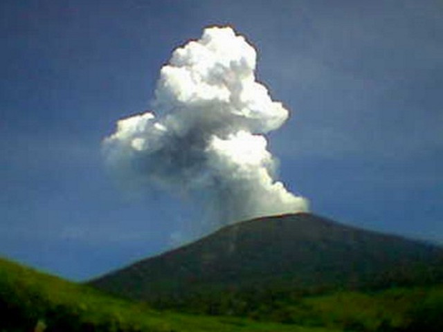 |
Figure 1. Photo of the plume resulting from Dempo's phreatic eruption on 25 September 2006. This is one of a set of multiple photos taken of a rising plume. Photo by Fredy, a local resident. Courtesy of CVGHM. |
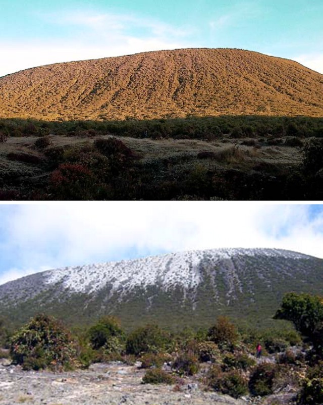 |
Figure 2. (top) Pre-eruption and (bottom) post-eruption scenes from the saddle between the cones of Dempo and Marapi looking upslope towards Marapi (which contains the source vent in a steep-sided crater not visible from this perspective). The shots were taken on 7 and 26 September 2009, respectively. Freshly deposited mud and evidence of ejected crater-lake water in the foreground (bottom) represents distal deposits from the 25 September eruption; note peson at right for scale. Large blocks were not from this eruption. Courtesy of the Dempo inspection team, CVGHM. |
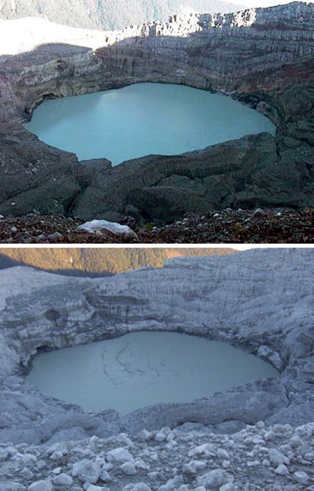 |
Figure 3. Pre- and post-eruption photos looking into Marapi crater at Dempo, taken on 7 (top) and 26 (bottom) September 2006. The lake is on the order of 400 m across. The bottom photo portrays the crater's mud-covered walls and sediment-covered lake. Comparison of both photos indicates that after the eruption the lake surface had dropped, consistent with discharge of water and mud. Camera look-direction unstated. Courtesy of the Dempo inspection team, CVGHM. |
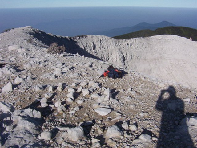 |
Figure 4. Post-eruption conditions on Dempo's Marapi cone seen from a point a few meters back from the crater rim. Widespread gray-to-brown mud covered the rim and upper crater, creating a desolate scene. The large angular blocks on the rim were placed there in previous events, not the 25 September 2009 eruption. Unstated direction; photographers shadow and gear for scale. Courtesy of the Dempo inspection team, CVGHM. |
Geological Summary. Dempo is a stratovolcano that rises above the Pasumah Plain of SE Sumatra. The andesitic complex has two main peaks, Gunung Dempo and Gunung Marapi, constructed near the SE rim of a 3-km-wide amphitheater open to the north. The high point of the older Gunung Dempo crater rim is slightly lower, and lies at the SE end of the summit complex. The taller Marapi cone was constructed within the older crater. Remnants of seven craters are found at or near the summit, with volcanism migrating WNW over time. The active 750 x 1,100 m active crater cuts the NW side of the Marapi cone and contains a 400-m-wide lake at the far NW end. Eruptions recorded since 1817 have been small-to-moderate explosions that produced local ashfall.
Information Contacts: Center of Volcanology and Geological Hazard Mitigation (CVGHM), Jalan Diponegoro 57, Bandung 40122, Indonesia (URL: http://vsi.esdm.go.id/).