Report on Kilauea (United States) — March 2009

Bulletin of the Global Volcanism Network, vol. 34, no. 3 (March 2009)
Managing Editor: Richard Wunderman.
Kilauea (United States) June to December 2007 activity; multiple fissure eruptions
Please cite this report as:
Global Volcanism Program, 2009. Report on Kilauea (United States) (Wunderman, R., ed.). Bulletin of the Global Volcanism Network, 34:3. Smithsonian Institution. https://doi.org/10.5479/si.GVP.BGVN200903-332010
Kilauea
United States
19.421°N, 155.287°W; summit elev. 1222 m
All times are local (unless otherwise noted)
The long-term eruption of Kīlauea, continuing since January 1983, is well documented in reports issued by the Hawaiian Volcano Observatory (HVO) and in the literature (eg., Poland and others, 2008), and is thus only episodically covered in our Bulletin. This report begins bringing coverage up to date by summarizing activity during the last half of 2007. Events included lava returning to Pu`u `O`o on 2 July, a fissure eruption on 21 July, and the Thanksgiving Eve Breakout (TEB) on 21 November. This report starts with a discussion of the Father's Day Intrusion, or Episode 56, an event heralded by increased summit activity on 17 June 2007 (BGVN 32:06).
Father's Day Intrusion (Episode 56) and Pu`u `O`o activity. According to HVO, on Father's Day, 17 June 2007, a swarm of earthquakes and rapid deflation began at 0215 in the upper E rift zone. The earthquakes were centered under Pauahi Crater ~ 1 km SW of the Mauna Ulu shield volcano, and ~ 1.5-3 km deep. Rapid ground tilting was detected at Mauna Ulu. About 70 earthquakes were recorded in the first 2 hours; at least ten of those were M 3 or greater. National Park Service (NPS) crews evacuated visitors and closed the Chain of Craters road and part of the Crater Rim drive.
Fresh cracks about 2 cm wide opened in the Chain of Craters road near the turnoff to Mauna Ulu. Within a few hours, GPS receivers in the area of most intense seismic activity documented an approximate 10 cm of widening across the rift zone, near Makaopuhi crater. The deformation and earthquakes were inferred as associated with magma intrusion that started in the Mauna Ulu area early on 17 June and subsequently moved slowly 6 km E along the East rift zone. HVO observers noted rockfalls from the S wall of Pu`u `O`o cone and collapse of the crater floor around the vents. Some parts of the crater floor subsided up to 80 m within a few days.
On 18 June, the earthquake swarm slowed to ~ 10-15 small earthquakes per hour. Strong tremor beneath the summit was recorded and deflation continued. GPS receivers continued to show extension across the East rift zone, to ~ 100 cm in some areas. Between 18 and 19 June, a new 50-m-long lava flow emerged from a 200-m-long fissure in the forest NE of Kane Nui o Hamo, about 6 km W of Pu`u `O`o. Steam plumes were spotted on the N flank of Kane Nui o Hamo (figure 190).
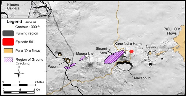 |
Figure 190. Map of Kīlauea's Father's Day Intrusion showing Kīlauea caldera and key features and activity near the Makaopuhi crater on 20 June 2007. A small lava flow erupted from a 250-m-long fissure in the forest NE of Kane Nui o Hamo. The lava was cooling and not advancing when observed at 0700 on 19 June. Courtesy of USGS-HVO. |
On 20 June, seismicity and extension decreased on the East rift zone. HVO scientists measured highly elevated sulfur dioxide gas concentrations, greater than 10 parts per million (ppm), in a broad area adjacent to Halema'uma'u crater. Elsewhere typical concentrations were generally negligible except for areas downwind of Halema'uma'u crater, where they reached up to 2.5 ppm in narrow zones.
During 21 June-1 July 2007, no fresh lava was visible on the flow field or at the site of the 18-19 June eruption. The summit area continued to inflate very slowly and seismic tremor values at Pu`u `O`o were below pre-June 17 levels. Ground-based mapping of the new lava flow indicated the eruption occurred from two places along the fissure, separated by ~ 40 m. The intrusion and extension processes had drained a substantial amount of magma from the summit reservoir; Pu`u `O`o's crater collapsed to a level 100 m deeper and the lava tubes drained.
Lava in Pu`u `O`o Crater (Episode 57). On 2 July, HVO scientists saw new lava flows at the bottom of the collapsing Pu`u `O`o crater; incandescence had last been seen there on 18 June. Two vents feeding the lake were identified: the W vent, initially the most active, and the E vent (figure 191). During 3-13 July, a lava lake grew and filled the crater to within 30 m of the rim. On the S wall of West Gap pit, intermittent incandescence and fuming from new vents that opened were observed during 13-14 July. In addition, the level of the lava lake dropped but lava continued to emit from the E vent. On 15 July, the E and W vents erupted small lava flows that drained onto the solidifying lava lake bed. Low lava fountains extruded from West Gap pit. Within a few days, lava filled the pit and overflowed into the main crater.
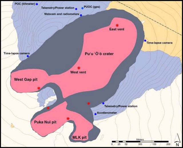 |
Figure 191. Map of the Pu`u `O`o crater as of 20 July, 2007. The dark gray shaded area represents the composite area of collapse, including the main crater and flank vent pits, following the Father's Day event. The key identifies new lava (episode 57) erupted at Pu`u `O`o shown in light red in colored versions; areas mainly in the center of the crater. Vents active during episode 57 are shown as asterisks. Courtesy of USGS-HVO. |
During 18-21 July, the E vent and dominant W vent in Kīlauea's Pu`u `O`o produced lava flows. New vents opened in the Puka Nui pit, in the SSW area of Pu`u `O`o crater, and produced lava flows that ponded there. A low lava fountain occasionally fed the lake from the vicinity of a spatter cone; an unseen source also fed the lake from the NW edge. A vent high on the S crater wall, adjacent to the Puka Nui Gap pit, produced spatter and propelled lava bombs 10 m into the air. Meanwhile, the lava lake in the West Gap pit continued to fill, overturn, and occasionally overflow. The spatter cone that built up around the S wall vent in West Gap pit was submerged beneath the lava lake surface on 20 July. Uplift of the crater interior continued. Earthquakes occurred beneath the upper E rift zone, S flank, and Halema'umau crater.
Fissures A-D. Late on 20 July, a tiltmeter recorded a nearly 300 microradian of change as Pu`u `O`o's crater floor started to subside. Early on 21 July, the West Gap lava lake and Puka Nui pit drained. A new eruption initiated along a set of fissures (figure 192) that extended 1.7 km E from a point about 150 m E of the E rim of Pu`u `O`o crater.
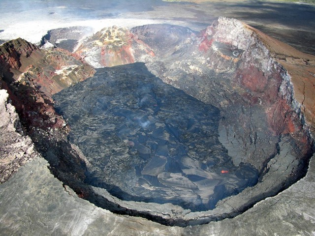 |
Figure 192. Aerial view at Kīlauea showing Pu`u `O`o crater looking WNW on the morning of 13 July 2007. Viewers saw two active vents in the collapsed crater floor. The incandescent E vent is near the lower right part of the crater bottom, and the W vent (less incandescent in this image) is near the middle of the image. Courtesy of USGS-HVO. |
Preliminary reports described two 600-800 m long, left-stepping, ENE-trending fissures between Pu`u `O`o and Kupaianaha. The easternmost fissure fed two lava flows, the longer of which reached ~ 2 km SE from the fissure. The lower fissure consisted of three segments, making a total of four. The four fissure segments, A, B, C, and D, defined an approximately 2 km-long line (figure 193).
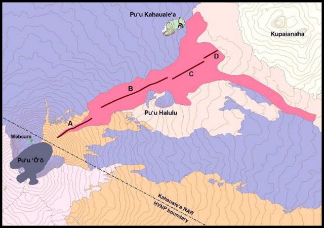 |
Figure 193. Map showing Kīlauea's eruptive fissure segments A, B, C, and D and aerial extent of lava flows from the 21 July eruption (as documented that day). Courtesy of USGS-HVO. |
The westernmost fissure (segment A) was inactive by 21 July and the uppermost segment of the active lower fissure (segment B) was completely sealed by mid-morning on 22 July. The rest of the fissure erupted lava fountains 6-8 m high, constructing several small perched ponds that occasionally overflowed to feed a few longer lava flows. These formed as the edges of pools of lava hardened to create confining walls. These walls enabled the pond's surface to be much higher, in some cases as much as 18 m or higher than the surrounding land. The ponds were as large as 200 m in diameter.
During 23 July to mid-August, fissure segments C and D fed perched lava ponds created by the NE-advancing `a`a flow. The ponds both grew in thickness and spilled lava over the levees along their edges, or at breaches. By 31 July, segment B had become inactive. By about 12 August, lava ceased extruding at segment C.
During the rest of August through most of November, fissure segment D continued to feed advancing `a`a lava flows that frequently escaped the confines of the levees. Lava flows that branched from the main channel continued to advance, widening and lengthening the flow field. Lava occasionally escaped from lava tubes.
Fissure D and TEB. On 21 November, lava escaped from a perched channel near fissure D. This lava flow became known as the TEB (Thanksgiving Eve Breakout). The bypass of lava from the channel to the surface resulted in an estimated 10 m drop in channel levels. The redirected lava quickly formed two channelized pahoehoe flows; one advanced 300 m N and the second flow advanced 1 km SE.
During 23-27 November, lava built a low shield over the TEB and fed one flow that advanced 2 km. A small lava pond at the top of the TEB shield overflowed and fed lava flows in multiple directions. Clear web-camera views on 9 and 10 December revealed that the TEB shield continued to build vertically and was then an estimated 15 m high. On 16 December, a 4-5-m-high hornito at the summit of the TEB shield was active. On 17 December, fume puffed from the top of the shield about every 15-20 minutes when visible.
An overflight on 20 December revealed that lava from fissure D built up two more shields SE of the TEB shield. These shields were considered "rootless shields." That term is described by HVO scientists as "...smaller, shield-shaped mounds that form on active lava flows [and] are fed by shallow lava tubes that flow just below the surface."
During 25 December-1 January lava escaped at both the TEB shield and two satellitic shields. Short lava flows traveled SE and N.
Reference. Poland, M., Miklius, A., Orr, T., Sutton, J., Thornber, C., and Wilson, D., 2008, New episodes of volcanism at Kīlauea volcano, Hawaii: EOS, Transactions of the Am. Geophys. Union, v. 89, no 5, p. 37-38, 29 January 2008.
Geological Summary. Kilauea overlaps the E flank of the massive Mauna Loa shield volcano in the island of Hawaii. Eruptions are prominent in Polynesian legends; written documentation since 1820 records frequent summit and flank lava flow eruptions interspersed with periods of long-term lava lake activity at Halemaumau crater in the summit caldera until 1924. The 3 x 5 km caldera was formed in several stages about 1,500 years ago and during the 18th century; eruptions have also originated from the lengthy East and Southwest rift zones, which extend to the ocean in both directions. About 90% of the surface of the basaltic shield volcano is formed of lava flows less than about 1,100 years old; 70% of the surface is younger than 600 years. The long-term eruption from the East rift zone between 1983 and 2018 produced lava flows covering more than 100 km2, destroyed hundreds of houses, and added new coastline.
Information Contacts: Hawaiian Volcano Observatory (HVO), U.S. Geological Survey, PO Box 51, Hawai'i National Park, HI 96718, USA (URL: https://volcanoes.usgs.gov/observatories/hvo/).