Report on Fernandina (Ecuador) — April 2009

Bulletin of the Global Volcanism Network, vol. 34, no. 4 (April 2009)
Managing Editor: Richard Wunderman.
Fernandina (Ecuador) Lava flows from a 10-28 April fissure eruption reach the sea
Please cite this report as:
Global Volcanism Program, 2009. Report on Fernandina (Ecuador) (Wunderman, R., ed.). Bulletin of the Global Volcanism Network, 34:4. Smithsonian Institution. https://doi.org/10.5479/si.GVP.BGVN200904-353010
Fernandina
Ecuador
0.37°S, 91.55°W; summit elev. 1476 m
All times are local (unless otherwise noted)
In early April 2009, Fernandina (also known as La Cumbre volcano) erupted. According to the Ecuador Institute of Geophysics (IG), satellite data suggested that the eruption began sometime between 2200 on 10 April and 0030 on 11 April. The seismic station at Puerto Ayora, on the nearby island of Santa Cruz, recorded no earthquakes associated with this eruption. High numbers of thermal anomalies ended after 28 April. Although no report is available, photos posted by the IG show steam rising from the eruptive fissure, but no active lava emission, on 1 May.
On the morning of 11 April an eruptive column was seen by both a passing tourist boat and Galápagos National Park rangers located on Canal Bolívar. Authorities at the National Park reported both lava flows and ash plumes. A true-color MODIS image taken on the morning of 11 April showed an ash-and-steam plume rising from the area of active lava flows (figure 7).
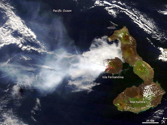 |
Figure 7. Terra MODIS satellite image of volcanic activity on Isla Fernandina, 11 April 2009 (1610 UTC). Its larger neighbor, Isla Isabela, encircles the island's E side. The plume extended over the ocean and diffuse portions remained visible at least 150 km W. The diffuse plume's contours partly cover denser zones of billowy weather clouds. The outline on the SW side of Isla Fernandina shows the margin of the hotspot detected on this date by MODIS. Courtesy of Jeff Schmaltz and Michon Scott, NASA MODIS Rapid Response Team and NASA Earth Observatory. |
Galápagos National Park Rangers conducted a flyover on 13 April 2009 (figure 8) and found the eruption's intensity undiminished. The eruption source was a fissure on the SW flank, in an area ~ 500 m from the summit crater near the site of the 2005 eruption. The fissure was ~ 200 m long and 10 m wide, and ejected lava fountains 15 m high. A gas-and-ash plume drifted SW. Lava traveled several kilometers in a single flow, then downslope it divided into three branches. Further downslope it merged into two flows, both of which reached the ocean. A large column of steam rose where lava poured into the ocean.
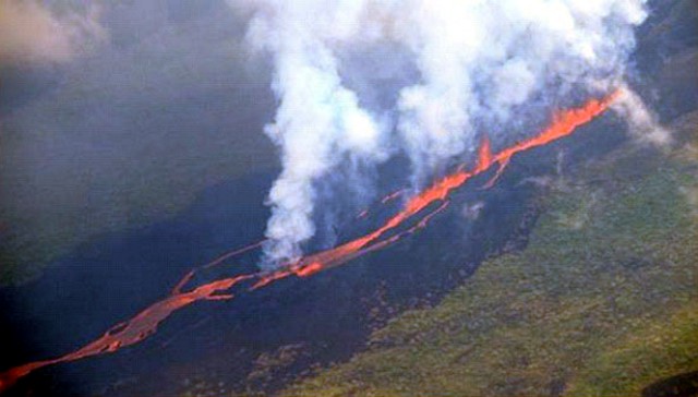 |
Figure 8. Aerial photo of Fernandina, 13 April 2009, showing fountaining lava along a fissure feeding lava flows downslope (left). Courtesy of the Office of Public Relations, Galápagos National Park Service. |
During an overflight on the morning of 15 April, personnel from the Galapagos National Park Service (GNPS) verified that the eruption continued, but with less intensity. Three vents at ~ 400 m elevation on the southwest flank along the radial fissure were active (figure 9), feeding a lava flow up to 10 m wide. The area was free of clouds, making it possible to observe a band of hot water along the coastline of the island, near the point at which the lava enters the ocean. According to a preliminary report from the research vessel sent by the GNPS to the eruption site, the lava has caused deaths among different species of fish and killed several fur seals. During 15-16 April gas-and-steam plumes from Fernandina drifted up to 555 km W.
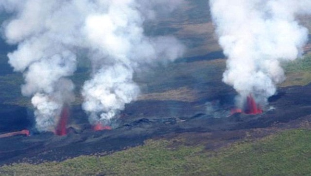 |
Figure 9. Aerial photo of Fernandina, 15 April 2009, showing three active vents along the radial fissure. Courtesy of the Office of Public Relations, Galápagos National Park Service. |
Satellite imagery. Satellite images posted by NASA Earth Observatory showed ash plumes on 11, 12, and 27 April in MODIS imagery. All of the plumes were moving W and interpreted as ash-bearing. Based on analysis of satellite imagery, the Washington VAAC reported that during 11-14 April, gas and possible ash plumes expanded laterally up to both 300 km W and 270 km N. The eruption also produced a substantial plume of sulfur dioxide (SO2) seen in Ozone Monitoring Instrument (OMI) imagery that extended far W of the islands over the Pacific Ocean (figure 10). The Aura image indicated a tentative mass of 1.47 x 10⁵metric tons. NASA's Cloud-Aerosol Lidar and Infrared Pathfinder Satellite Observations (CALIPSO) also detected a substantial low-altitude sulfate aerosol plume at an altitude of ~ 3 km.
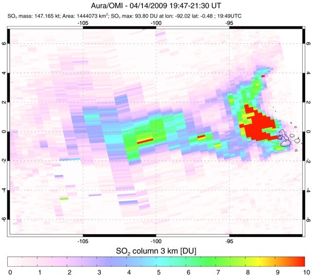 |
Figure 10. Plume of SO2 that extended far W of Fernandina, over the Pacific Ocean, imaged by the Ozone Monitoring Instrument (OMI) on NASA's Aura satellite from 1947-2130 UTC on 14 April 2009. In this image, SO2 is measured in Dobson Units. (See key to shading of colors along bottom edge.) NASA image courtesy Simon Carn. |
MODVOLC Thermal Alerts.Thermal anomalies detected by the MODVOLC system were measured from 11 April to at least 12 May 2009 (figure 11). After the initial widespread pixels on 11 April, the thermal alerts were all located on the SW flank below the caldera, and extended down to the ocean. From 11-28 April, the number of the alerts during any satellite pass was rather large, ranging from 45 pixels at the onset of the eruption to 20 pixels after two weeks. Intermittent anomalies were detected through 21 May 2009.
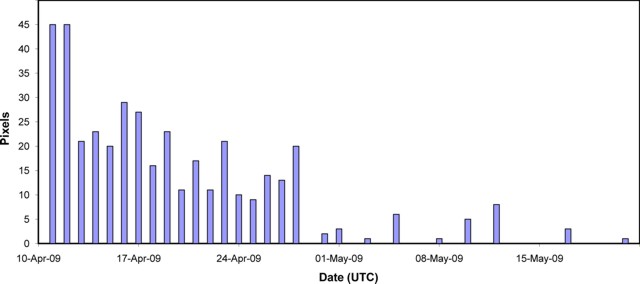 |
Figure 11. Graph showing the largest number of daily MODVOLC thermal alerts at Fernandina, 10 April-22 May 2009. For many of the days during this event, thermal alerts were measured in 3-4 satellite crossings; only the crossing with the highest number of pixels per day were selected for the graph. Data courtesy of Hawai'i Institute of Geophysics and Planetology (HIGP) Thermal Alerts System. |
Geological Summary. Fernandina, the most active of Galápagos volcanoes and the one closest to the Galápagos mantle plume, is a basaltic shield volcano with a deep 5 x 6.5 km summit caldera. The volcano displays the classic "overturned soup bowl" profile of Galápagos shield volcanoes. Its caldera is elongated in a NW-SE direction and formed during several episodes of collapse. Circumferential fissures surround the caldera and were instrumental in growth of the volcano. Reporting has been poor in this uninhabited western end of the archipelago, and even a 1981 eruption was not witnessed at the time. In 1968 the caldera floor dropped 350 m following a major explosive eruption. Subsequent eruptions, mostly from vents located on or near the caldera boundary faults, have produced lava flows inside the caldera as well as those in 1995 that reached the coast from a SW-flank vent. Collapse of a nearly 1 km3 section of the east caldera wall during an eruption in 1988 produced a debris-avalanche deposit that covered much of the caldera floor and absorbed the caldera lake.
Information Contacts: Geophysical Institute (IG), Escuela Politécnica Nacional, Apartado 17-01-2759, Quito, Ecuador (URL: http://www.igepn.edu.ec/); Galápagos National Park Service, Ministry of the Environment, Isla Santa Cruz, Galápagos, Ecuador (URL: http://www.galapagospark.org/); Galapagos Conservancy, 11150 Fairfax Blvd, Suite 408, Fairfax, VA 22030, USA (URL: http://www.galapagos.org/); Washington Volcanic Ash Advisory Center (VAAC), Satellite Analysis Branch, NOAA/NESDIS E/SP23, NOAA Science Center Room 401, 5200 Auth Road, Camp Springs, MD 20746, USA (URL: http://www.ssd.noaa.gov/); Hawai'i Institute of Geophysics and Planetology (HIGP) Thermal Alerts System, School of Ocean and Earth Science and Technology (SOEST), Univ. of Hawai'i, 2525 Correa Road, Honolulu, HI 96822, USA (URL: http://modis.higp.hawaii.edu/); Simon Carn, Dept of Geological and Mining Engineering and Sciences, Michigan Technological University, 1400 Townsend Dr., Houghton, MI 49931, USA (URL: https://so2.gsfc.nasa.gov/); NASA Earth Observatory (URL: http://earthobservatory.nasa.gov/).