Report on Ol Doinyo Lengai (Tanzania) — May 2009

Bulletin of the Global Volcanism Network, vol. 34, no. 5 (May 2009)
Managing Editor: Richard Wunderman.
Ol Doinyo Lengai (Tanzania) Minor spattering, explosions, ash falls, and lava flows through April 2009
Please cite this report as:
Global Volcanism Program, 2009. Report on Ol Doinyo Lengai (Tanzania) (Wunderman, R., ed.). Bulletin of the Global Volcanism Network, 34:5. Smithsonian Institution. https://doi.org/10.5479/si.GVP.BGVN200905-222120
Ol Doinyo Lengai
Tanzania
2.764°S, 35.914°E; summit elev. 2962 m
All times are local (unless otherwise noted)
This report chiefly discusses observations made at Ol Doinyo Lengai (hereafter called Lengai) in the first half of 2009. Broadly speaking, the active N crater continued to be the scene of venting. More specifically, the cone that covers much of what was the N crater contained a steep-sided crater with a tight cluster of active hornitos and spatter cones on its floor. Conditions during 2009 visits were generally calm, although minor eruptions on the crater floor continued. This is in contrast to explosive eruptions during September 2007-March 2008 (BGVN 32:11, 33:02, 33:06, 33:08, 34:02).
In the late stages of preparing this issue we received a report from Tobias Fischer stating that when he and his team visited on 11-12 June 2009, one side of the crater contained a convecting lava lake. That report will appear in our next issue.
Most of the groups that arrived at Lengai in 2009 did not ascend to the active crater and the SE route remained difficult. Gas samples collected here in 2005 were published and interpreted in Fischer and others (2009). The next subsection confirms original interpretations of a 2007 satellite image.
September 2007 ASTER image. David Sherrod was among USGS visitors during January 2009, working with local government officials and studying tephra deposits from explosive eruptions during September 2007-March 2008 that were distributed well out from the volcano (BGVN 34:02). When commenting about the cause of the large lobate black areas on Lengai's NW, W, and E sides seen in ASTER imagery from 4 September 2007 (BGVN 32:11) he noted, "the lava flows of late 2007-early 2008 are far more restricted than the blackened areas visible on the photos."
This is in agreement with the statement by Roger Mitchel in the original discussion (and the original figure caption). Sherrod also said, "I'm fairly certain [the dark lobes] are burn areas. The fires can be natural, but they are also set by herdsman to improve access and grass quality. The dark areas show on many past images, including those from times in the absence of eruptions. They commonly have well-defined margins and thorough coverage within. Lava flows have well defined margins but more erratic coverage within the bounds, creating digitate lobes."
Comments on aviation hazards during 2007-2008. Comparatively few pictures or comments on aviation hazards have emerged from the recent episode of Plinian eruptions during 2007-2008. Ben Wilhelmi took a series of photos of the ground surface at distance from the volcano during a week in November 2007. From the air he saw ash as far away as 70 km from the volcano, including in many cases, over Masai villages that dot the landscape.
Wilhelmi's discussion and photos follows. "[During] 2007 and 2008 ... smoke and ashes sometimes [rose] up to 50,000 ft, 15 km high. It looked like a Hiroshima mushroom [cloud (figure 122)]. Here is ash deposit on my aircraft [(figure 123)]. Often the ash was invisible in the air though. [Three] turbine engines died in different companies because of ash intakes. It happened one of these engines [died] on me. Luckily I could finish the flight, but I didn't like the feeling to see the engine temperature in the red and [flying] on reduced power.
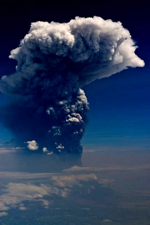 |
Figure 122. A tall (roughly 15-17 km altitude) Ol Doinyo Lengai plume from the 2007-2008 eruptive interval taken at unstated date and directional bearing. Short burst of lightning were visible in the plume but were not captured in this photo. Courtesy of Ben Wilhelmi. |
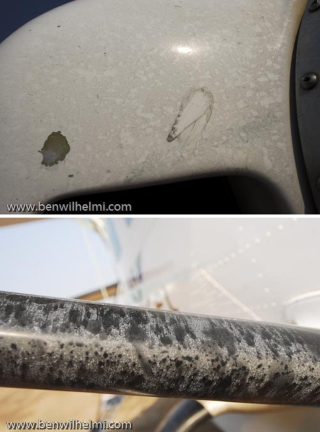 |
Figure 123. Two photos of Ol Doinyo Lengai ash deposits on leading surfaces of a small propeller-driven airplane from encounter with ash while in flight. Photographer and pilot Ben Wilhelmi commented that the ash was often invisible during the encounter. |
"In other countries, such an activity [as seen in figure 122] would have imposed the area to be closed within 200 miles [~320 km], that would have included Arusha and all the Serengeti [and] Ngorongoro [park and conservation areas]. "Competent" authorities were asleep, the regional companies happily kept on flying ... and subsequently lost 3 engines as I've said earlier. Costs could go up to $350,000 for a new turbine engine ... I certainly didn't complain as I could shoot [photos at will and] got to see incredible spectacles like this day with a 55,000 ft or 17 km high plume of smoke with an electric thunderstorm inside!"
February 2009 visit. Anatoly Zaitsev and Gregor Markl reported that in mid-February 2009 a group from St. Petersburg, Russia (A.N. Zaitsev, S.V. Petrov, T.A. Golovina, and E.O. Zaitseva) and Tuebingen, Germany (G. Markl and T. Wenzel) climbed the volcano. There were no ash or gas emissions during the visit, although on the crater floor lava bubbled and spattered.
The group reached the summit around 0830 on 18 February after ~ 4.5 hours of climbing. They ascended along the traditional W route (an approach enabling rapid access but potentially exposing climbers to eruptive debris). They stayed on the summit and in the N crater for ~ 5 hours. On the large cone in the N crater they walked around the active crater's rim on the W, S, and E sides (figure 124). They crossed the depression between the two rims on the S side of the cone, the outer rim belonging to an earlier stage of development, the inner rim lying along the margin of the current crater. In that depression they found meter-sized blocks (figure 125).
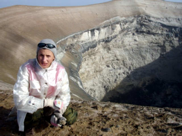 |
Figure 124. Ol Doinyo Lengai's active crater as seen looking W along the rim. The crater resides in the cone that grew in the N crater in the past few years. Photo taken 18 February 2008. Courtesy of Sergey Petrov. |
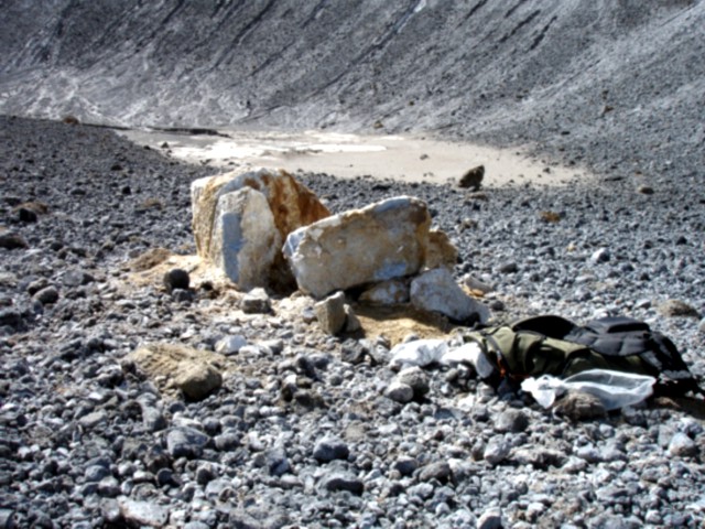 |
Figure 125. Large blocks found in the depression along the S upland portion of the active cone in Ol Doinyo Lengai's N crater. Note field gear for scale (right foreground). Photo courtesy of Tamara Golovina. |
Three hornitos (spatter cones) were observed deep in the crater floor. One, with a broken upper part, was active throughout the visit. Inside that hornito they saw bubbling lava, and several times black spatter was ejected.
The surface of the cone around the deep pit crater's rim consisted of gray fine-grained ash with rare blocks of ejected silicate rocks. Later analysis of a sample taken from the surface of the cone using X-ray diffraction indicated significant amounts of calcite in addition to silicate minerals. The depression between the rims of a new and old craters was covered by numerous blocks and bombs of silicate rocks (nephelinites, wollastonite nephelinites, and ijolites) and partly altered natrocarbonatites.
Fumarolic activity in the northern crater was weak. The group observed just a few small cracks emitting gases that were relatively cold-probably less than 100°C.
Summary of 2009 visits. Table 22 shows a list of observers known to have visited or flown over Lengai since 2009 began. Available photos and text indicate that on the crater floor, hornitos continued to spatter lava. Otherwise, relative calm was seen, typically even devoid of steam, during much of the interval 1 October 2008 through 25 April 2009.
Table 22. Summary of selected observations of Ol Doinyo Lengai (from a climb, aerial overflight, flank, or satellite) during January-April 2009. Courtesy of Ben Wilhelmi and Frederick Belton.
| Date | Observer | Observation Location | Brief Observations |
| 18-22 Jan 2009 | Representatives from the U.S. Geological Survey, U.S. Agency for International Development, Geological Survey of Tanzania, and Tanzania Prime Minister's Office. | Flank | See BGVN 34:02. |
| 18 Feb 2009 | A.N. Zaitsev, S.V. Petrov, T.A. Golovina, E.O. Zaitseva, G. Markl, and T. Wenzel | Climb | See text above. |
| 14 Mar 2009 | Stefan Lubben | Climb | Climbed through the Pearly Gates without difficulty. At summit, they smelled sulfur but heard nothing from the volcano. |
| 07 Apr 2009 | Alexander Daneel | Aerial | Photos indicate small cones on the crater floor in similar spots to those seen active by H. Loubieres and F. Vignes on 1 September 2008 (BGVN 33:08) (see figure 126). This lack of change suggests only minor volcanism from the crater during 1 September 2008 to 7 April 2009. |
| 25 Apr 2009 | Ben Wilhelmi | Aerial | Photos showing numerous hornitos with spatter widespread on the crater floor and in places on the crater walls (see figure 127). |
Regarding his March visit to the summit, Stefan L?bben reported that amid wet and windy weather they could smell sulfur. But they heard nothing from the volcano.
On 7 April 2009 Alexander Daneel photographed the summit crater from the air (figure 126). Some of the same small lava cones inside the crater were seen to be active by Hervé Loubieres and Fran?oise Vignes on 1 September 2008. An aerial view on 25 April showed numerous hornitos that had formed in the previous 4-5 months (figure 127).
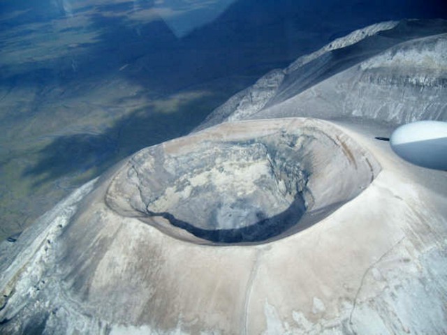 |
Figure 126. Aerial view on 7 April 2009 looking SW across the Ol Doinyo Lengai crater. On the rim's E side there is a small slump (at left). Courtesy of Alexander Daneel. |
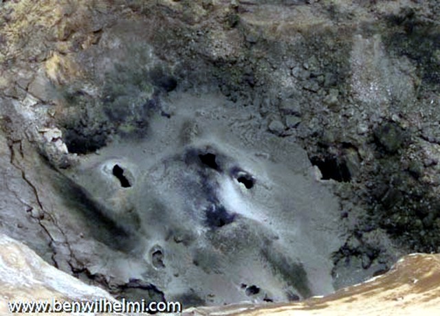 |
Figure 127. Aerial photo of Ol Doinyo Lengai's crater floor taken on 25 April 2009 with uncertain orientation with respect to N. The floor contains numerous hornitos. According to the pilot and photographer, Ben Wilhelmi, who often flies over for observations, these features probably formed during the previous 4-5 months. Courtesy of Ben Wilhelmi. |
Gas chemistry. Based on chemical analyses of gas samples collected by Bernard Marty in July 2005 (BGVN 30:10) (figure 128), Fischer and others (2009) reported that a very small amount of melting of Earth's mantle, akin to that beneath mid-ocean ridges, can produce carbonatites. Their gas samples, containing minimal air contamination, revealed that the carbon dioxide came from the upper mantle below the East African Rift.
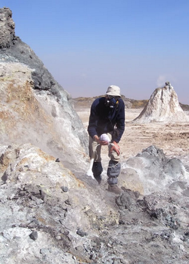 |
Figure 128. Collecting volcanic gas samples at Ol Doinyo Lengai's active crater in 2005 (Fisher, 2009). Courtesy of Tobias Fischer, University of New Mexico. |
Fischer and others (2009) state, "On a global scale, our results imply that the regions of upper mantle beneath mid-ocean ridges, continental North America, and the East African Rift were identical in their volatile abundances and isotopic compositions. Despite small differences in some trace gases (for example Xe isotopes in MORBs-mid-ocean ridge basalts-versus [gases from continental wells]), the upper mantle appears to be a uniform and homogenous geochemical reservoir of CO2 and other gases (N2, He, and Ar) below both continent[s] and oceans."
Reference. Fischer, T.P., Burnard, P., Marty, B., Hilton, D.R., F?ri, E., Palhol, F., Sharp, Z.D., and Mangasini, F., 2009, Upper-mantle volatile chemistry at Oldoinyo Lengai volcano and the origin of carbonatites, Nature, v. 459, p. 77-80 (doi:10.1038/nature07977).
Geological Summary. The symmetrical Ol Doinyo Lengai is the only volcano known to have erupted carbonatite tephras and lavas in historical time. The prominent stratovolcano, known to the Maasai as "The Mountain of God," rises abruptly above the broad plain south of Lake Natron in the Gregory Rift Valley. The cone-building stage ended about 15,000 years ago and was followed by periodic ejection of natrocarbonatitic and nephelinite tephra during the Holocene. Historical eruptions have consisted of smaller tephra ejections and emission of numerous natrocarbonatitic lava flows on the floor of the summit crater and occasionally down the upper flanks. The depth and morphology of the northern crater have changed dramatically during the course of historical eruptions, ranging from steep crater walls about 200 m deep in the mid-20th century to shallow platforms mostly filling the crater. Long-term lava effusion in the summit crater beginning in 1983 had by the turn of the century mostly filled the northern crater; by late 1998 lava had begun overflowing the crater rim.
Information Contacts: David Sherrod, Cascades Volcano Observatory, USGS, Vancouver, WA, USA; Anatoly Zaitsev, St. Petersburg State University, Saint Petersburg, Russia; Gregor Markl, Tuebingen, Germany; Frederick Belton, Developmental Studies Department, PO Box 16, Middle Tennessee State University, Murfreesboro, TN 37132, USA (URL: http://oldoinyolengai.pbworks.com/); Ben Wilhelmi (URL: http://benwilhelmi.typepad.com/benwilhelmi/).