Report on Karangetang (Indonesia) — May 2009

Bulletin of the Global Volcanism Network, vol. 34, no. 5 (May 2009)
Managing Editor: Richard Wunderman.
Karangetang (Indonesia) Elevated seismicity, lava flows in May 2009; high alert, evacuations
Please cite this report as:
Global Volcanism Program, 2009. Report on Karangetang (Indonesia) (Wunderman, R., ed.). Bulletin of the Global Volcanism Network, 34:5. Smithsonian Institution. https://doi.org/10.5479/si.GVP.BGVN200905-267020
Karangetang
Indonesia
2.781°N, 125.407°E; summit elev. 1797 m
All times are local (unless otherwise noted)
Lava flows from Karangetang (figure 7) reached several kilometers in length by the end of May 2009, and some residents evacuated. Witnessed plumes were minor, many below 100 m above the summit, the tallest 700 m above the summit. Intermittent minor activity, including explosions, ashfall, and thermal anomalies, has continued in the last few years (BGVN 32:05, 32:08, 34:01), with no significant changes since 2007 (figures 8 and 9).
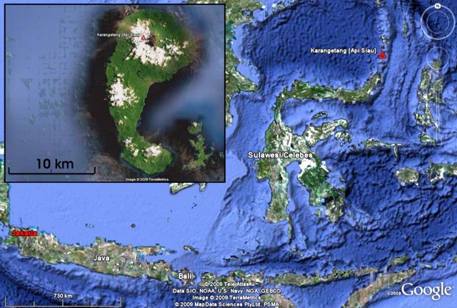 |
Figure 7. Map of the islands in the region around Karangetang, including Java, Bali, and Sulawesi (Celebes). Karangetang resides at upper right on Siau island, which is ~ 24-km-long, too small to see at this scale. (inset) An enlarged satellite image of Karangetang; white areas are clouds over volcanic peaks on the island. Maps have N directly upwards; scale bars are at lower left. Both maps courtesy of Google Earth. |
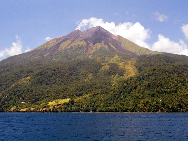 |
Figure 8. A 2007 photo of Karangetang taken from the sea (direction unspecified) showing multiple peaks and abundant unvegetated lava flows of young ages. The more distant cone may have been steaming. Photo by Mark Tolosa. |
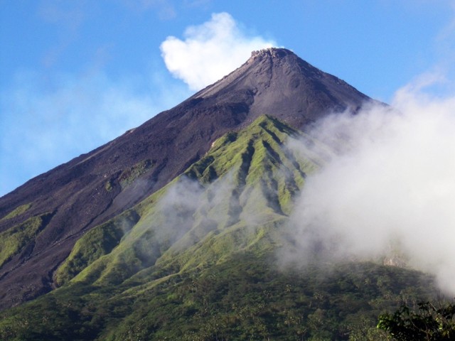 |
Figure 9. A photo of the summit area at Karangetang taken from the observatory station at Salili, S of the volcano, on 13 August 2007. Lava flows and rock avalanches during 2007 were not directly visible from this point. Note the rugged topography of the active lava dome at the summit. Courtesy of Arnold Binas. |
Based on a pilot observation, the Darwin VAAC reported that on 24 May an ash plume from Karangetang rose to an altitude of 3.7 km and drifted 75 km S. This was the tallest plume of the reporting interval.
On 31 May, based on seismicity, an increase in both volcanic tremor, and continuous air blasts (accompanied by rumbling sounds), the Center of Volcanology and Geological Hazard Mitigation (CVGHM) upgraded Karangetang's hazard status from Alert Level 3 (Siaga) to 4 (Awas) the highest level (figure 10). According to the website "Natural Disasters in Indonesia," hundreds of people were evacuated from near the volcano and the total number of vulnerable residents was 3,000. The Alert Level fell back to 3 on 9 June.
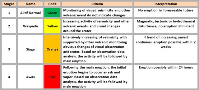 |
Figure 10. Alert levels applicable to Karangetang (and commonly used in Indonesia) with brief explanation of their significance. From the Natural Disasters in Indonesia website. |
Tremor was reported on 30 May and became continuous at times during the morning of 31 May (0600-1200). That same time interval saw the largest number of earthquakes. Craters I and II initially produced white plumes to heights of ~ 10-25 m and visible incandescence.
Beginning at 0630 a dense white to brownish plume from the principal crater reached a height of ~ 100 m above the peak. At 0824 there was a continuous expulsion of lava which flowed S, traveling ~ 2.3 km down the Kali Batuawang river. Lava also flowed ~ 1.5 km into the Kali Kahetang and Kali Keting rivers. Lava flows periodically traveled ~ 1 km down the Kali Nanitu and Batang rivers. At 0828 a thick grayish to plume was continuously ejected to a height of ~ 25-700 m accompanied by a rumbling sound of low to medium intensity.
In connection with the upgrading of the hazard status to Alert Level 4, CVGHM stepped up its monitoring and sent a team to the field. The regional government was alerted to the possible fallout of hot ash and the expulsion of lava flows. Numerous threatened towns and sub-districts were mentioned. These included Siau Timur, Kampung Kola-Kola (Bebali village); Kampung Bolo and Kampung Kopi, (Tarorane village); Kampung Hekang, Tatahadeng village, the village of Dame 1, the village of Karalung along the Kali Beha Timur river and, Kampung Dompase, along the banks of the Kali Nanitu and Kali Kinali rivers. There was the constant threat of lahar (mud flows) along the length of the rivers that originate from the active crater, including the Batu Awang, Kahetang, Keting, Batang, Beha Timur, and Nanitu rivers.
People were cautioned not to approach Karangetang closer than 3 km from the summit, particularly under conditions of heavy rain. Residents of the village of Dame and part of the population of the township of Tatahadeng were advised to maintain a high level of alertness to the dangers of pyroclastic flows and lava flows. In the case of sudden tephra falls, authorities recommended the public don face masks. As previously mentioned, on 9 June 2009 the alert level was reduce from 4 to 3.
MODVOLC. There were numerous MODVOLC thermal alerts during 2 December 2008-25 February 2009 (BGVN 34:01). As of late June 2009, dates of subsequent MODVOLC alerts for Karangetang were 18 and 29 March; 25, 26, 28, and 30 April; and 7, 14, and 31 May; and 3 June. In effect, the alerts were broadly spread for more than a year and showed little if any response to the elevated activity seen during the crisis.
Geological Summary. Karangetang (Api Siau) volcano lies at the northern end of the island of Siau, about 125 km NNE of the NE-most point of Sulawesi. The stratovolcano contains five summit craters along a N-S line. It is one of Indonesia's most active volcanoes, with more than 40 eruptions recorded since 1675 and many additional small eruptions that were not documented (Neumann van Padang, 1951). Twentieth-century eruptions have included frequent explosive activity sometimes accompanied by pyroclastic flows and lahars. Lava dome growth has occurred in the summit craters; collapse of lava flow fronts have produced pyroclastic flows.
Information Contacts: Center of Volcanology and Geological Hazard Mitigation (CVGHM), Jalan Diponegoro 57, Bandung 40122, Indonesia (URL: http://vsi.esdm.go.id/); Hawai'i Institute of Geophysics and Planetology (HIGP) Thermal Alerts System, School of Ocean and Earth Science and Technology (SOEST), Univ. of Hawai'i, 2525 Correa Road, Honolulu, HI 96822, USA (URL: http://modis.higp.hawaii.edu/); Darwin Volcanic Ash Advisory Centre (VAAC), Bureau of Meteorology, Northern Territory Regional Office, PO Box 40050, Casuarina, NT 0811, Australia (URL: http://www.bom.gov.au/info/vaac/); Agence France-Presse (URL: http://www.afp.com/); Arnold Binas, Toronto, Canada (URL: http://www.summitpost.org/user_page.php?user_id=42443, http://www.flickr.com/photos/hshdude/collections/72157600584144439/).