Report on Ibu (Indonesia) — May 2009

Bulletin of the Global Volcanism Network, vol. 34, no. 5 (May 2009)
Managing Editor: Richard Wunderman.
Ibu (Indonesia) Thermal data suggest dome growth continued into mid-2009
Please cite this report as:
Global Volcanism Program, 2009. Report on Ibu (Indonesia) (Wunderman, R., ed.). Bulletin of the Global Volcanism Network, 34:5. Smithsonian Institution. https://doi.org/10.5479/si.GVP.BGVN200905-268030
Ibu
Indonesia
1.488°N, 127.63°E; summit elev. 1325 m
All times are local (unless otherwise noted)
Our last report on Ibu summarized MODVOLC thermal alerts (satellite thermal anomalies) from mid-May through late October 2008 (BGVN 33:09); those anomalies continued to be recorded almost monthly through June 2009. The anomalies suggest continued growth of a lava dome in the crater, an event previously documented by a photograph taken May 2000 and mentioned in BGVN 28:03. Authorities raised the hazard alert to Level 3 during June 2008. Several photos of Ibu in 2007 were taken by Arnold Binas (figure 2).
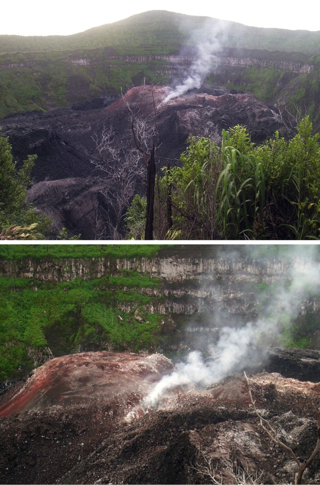 |
Figure 2. Photos of Ibu taken on 27 July 2007 from a point on the NW crater rim, looking approximately SE. The top photo shows the location of the dome in the steep-walled crater. The bottom photo shows a close-up view of the dome. Courtesy of Arnold Binas. |
Geological Summary. The truncated summit of Gunung Ibu stratovolcano along the NW coast of Halmahera Island has large nested summit craters. The inner crater, 1 km wide and 400 m deep, has contained several small crater lakes. The 1.2-km-wide outer crater is breached on the N, creating a steep-walled valley. A large cone grew ENE of the summit, and a smaller one to the WSW has fed a lava flow down the W flank. A group of maars is located below the N and W flanks. The first observed and recorded eruption was a small explosion from the summit crater in 1911. Eruptive activity began again in December 1998, producing a lava dome that eventually covered much of the floor of the inner summit crater along with ongoing explosive ash emissions.
Information Contacts: Center of Volcanology and Geological Hazard Mitigation (CVGHM), Saut Simatupang, 57, Bandung 40122, Indonesia (URL: http://vsi.esdm.go.id/); Hawai'i Institute of Geophysics and Planetology (HIGP) Thermal Alerts System, School of Ocean and Earth Science and Technology (SOEST), Univ. of Hawai'i, 2525 Correa Road, Honolulu, HI 96822, USA (URL: http://modis.higp.hawaii.edu/); Arnold Binas, Toronto, Canada (URL: http://www.summitpost.org/user_page.php?user_id=42443, http://www.flickr.com/photos/hshdude/collections/72157600584144439/).