Report on Manda Hararo (Ethiopia) — June 2009
Bulletin of the Global Volcanism Network, vol. 34, no. 6 (June 2009)
Managing Editor: Richard Wunderman.
Manda Hararo (Ethiopia) Fissure eruption generates lava flows and large SO2 plume
Please cite this report as:
Global Volcanism Program, 2009. Report on Manda Hararo (Ethiopia) (Wunderman, R., ed.). Bulletin of the Global Volcanism Network, 34:6. Smithsonian Institution. https://doi.org/10.5479/si.GVP.BGVN200906-221115
Manda Hararo
Ethiopia
12.17°N, 40.82°E; summit elev. 600 m
All times are local (unless otherwise noted)
A large SO2 cloud in southern Afar, Ethiopia was detected by the OMI instrument aboard NASA's EOS-AURA satellite on 29 June 2009 (figure 4). The cloud appeared to originate from the Karbahi region of the Manda Hararo rift segment, a graben area with numerous active faults, fissures, and basalt flows. The cloud was similar in size to that observed during a basaltic fissure eruption in August 2007 (BGVN 32:07). As reported by Simon Carn, the 29 June 2009 cloud had a total mass of 3.864 kt, an area of 186,710 km2, and an SO2 max of 4.75 DU (Dobson Units). Other clouds were also seen, including a large one on 30 June.
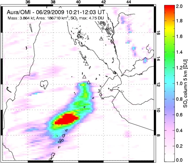 |
Figure 4. The eruptive SO2 cloud from Manda hararo over southern Afar region detected by the OMI instrument. Image acquired during 1021-1203 UTC on 29 June 2009. Courtesy of Simon Carn, Michigan Technological University. |
MODIS satellite imagery from 2320 UTC on 28-29 June confirmed that the SO2 cloud was associated with thermal anomalies appearing in the immediate vicinity of the August 2007 eruption. According to Charles Holliday, METEOSAT real time Active Fire Monitoring data derived from METEOSAT imagery suggests the eruption began within 15 minutes of 1715 UTC on 28 June 2009, about 7 hours after a magnitude 4.4 earthquake, identified by the Addis Ababa Geophysical Observatory and the European-Mediterranean Seismological Centre.
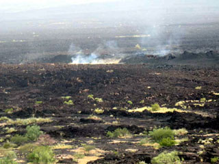
A field team of scientists, including Gezahegn Yirgu, Tesfaye Kidane, Elias Lewi, Tesfaye Chernet, Girma Wolde Tinsae, David Ferguson, Talfan Barnie, and Osman Mohammed, reached the site of the thermal anomalies by helicopter on 4 July 2009 and spent about two hours on the scene. They found the eruption had emitted predominantly a'a basalt flows, approximately 2-3 m thick that originated from fissures approximately 4-5 km long. The vent areas contained scoria ramparts approximately 30-50 m high. The field team collected rock and gas samples and surveyed the erupted material using visible and FLIR (Forward-Looking Infrared) cameras from both the air and the ground. Hand samples suggested the erupted lava was feldspar-bearing porphyritic basalt. No lava effusion was observed, although some steam was seen at the fissure (figure 5).
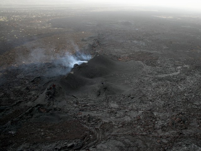 |
Figure 5. Oblique aerial photograph of Manda Hararo showing the eruptive fissure, scoria ramparts, and gas plume on 4 July 2009. Courtesy of Talfan Barnie, University of Cambridge. |
The fissure itself was inaccessible over land because it was surrounded by hot rock and could only be observed from a distance. Only a small part of the margins of the flow were visited on the ground due to limited time, rough terrain, and high temperature and humidity. The lava flows appeared to have cooled significantly, with the FLIR recording typical temperatures of between 30 and 120°C for the flow surfaces, and a maximum temperature of 238°C observed from the air (figure 6). The team made gas measurements at hot cracks in the flow front where they smelled volcanic gases and the FLIR registered temperatures over 100°C. According to David Ferguson, the group used FLIR thermal images to determine a safe route for walking. While the front of the lava flow had a dark black crust, similar to that of much colder flows, the FLIR camera on land recorded temperatures of up to 162°C around the cracks and fissures of the flow surface.
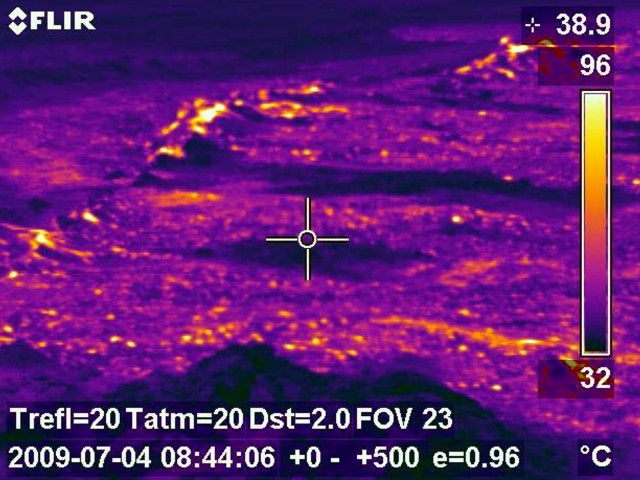 |
Figure 6. FLIR image of the 4 July 2009 eruption at Manda Hararo showing temperature distribution in and around the fissure. Courtesy of Talfan Barnie, University of Cambridge. |
A 6 July ASTER (Advanced Spaceborne Thermal Emission and Reflection Radiometer) image from the eruption site shows a warm 6.3 x 1.4 km flow erupted from a NW-SE trending fissure (figure 7). The area of the flow field is 4.0 km2. The coordinates of the center of the flow field are 40.655, 12.256. A 9 July EO-1 ALI panchromatic image shows the flow at a higher resolution (figure 8).
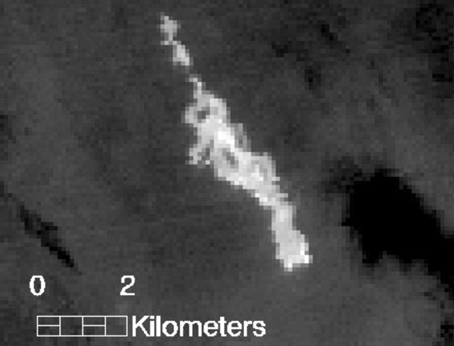 |
Figure 7. ASTER infrared image at Manda Hararo taken on 6 July 2009. The image shows a warm flow, 6.3 x 1.4 km, erupted from what looks like a NW-SE trending fissure. A clear pre-eruptive image from May 2009 shows nothing anomalous at this spot, indicating that the lava flow is new. The coordinates of the center of the flow field are 12.256°N, 40.655°E. Courtesy of Matt Patrick. |
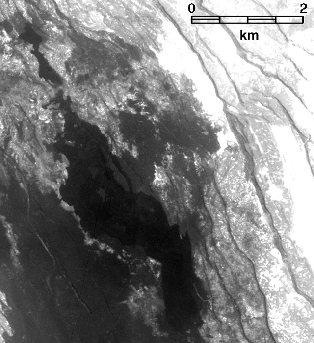 |
Figure 8. An EO-1 ALI panchromatic image (10-m pixel size) showing the flow at Manda Hararo on 9 July 2009. Courtesy of Matt Patrick. |
Geological Summary. As the southernmost axial range of western Afar, the Manda Hararo complex is located in the Kalo plain, SSE of Dabbahu volcano. The massive 105-km-long and 20-30 km wide complex represents an uplifted segment of a mid-ocean ridge spreading center. A small basaltic shield volcano is located at the N end of the complex, S of which is an area of abundant fissure-fed lava flows. Two basaltic shield volcanoes, the larger of which is Unda Hararo, occupy the center of the complex. The dominant Gumatmali-Gablaytu fissure system lies to the S. Voluminous fluid lava flows issued from these NNW-trending fissures, and solidified lava lakes occupy two large craters. The small Gablaytu shield volcano forms the SE-most end of the complex. Lava flows from Gablaytu and from Manda overlie 8,000-year-old sediments. Hot springs and fumaroles occur around Daorre lake. The first historical eruptions produced fissure-fed lava flows in 2007 and 2009.
Information Contacts: Gezahegn Yirgu, Dept of Earth Sciences, Addis Ababa University, P.O. Box 729/1033, Addis Ababa, Ethiopia; Simon Carn, Dept of Geological and Mining Engineering and Sciences, Michigan Technological Univ, 1400 Townsend Dr., Houghton, MI 49931, USA (URL: https://so2.gsfc.nasa.gov/); Afar Rift Consortium (URL: http://www.see.leeds.ac.uk/afar/); Charles Holliday, U.S. Air Force Weather Agency (AFWA)/XOGM, Offutt Air Force Base, NE 68113, USA; Hawai'i Institute of Geophysics and Planetology (HIGP) Thermal Alerts System, School of Ocean and Earth Science and Technology (SOEST), Univ. of Hawai'i, 2525 Correa Road, Honolulu, HI 96822, USA (URL: http://modis.higp.hawaii.edu/); guardian.co.uk Science Blog (URL: https://www.theguardian.com/science/blog); David Ferguson, Dept of Earth Sciences, Univ of Oxford, Parks Road, Oxford, OX1 3PR, United Kingdom; Talfan Barnie, Dept of Geography, Univ of Cambridge, Downing Place, Cambridge CB2 3EN, United Kingdom (URL: http://www.geog.cam.ac.uk/people/barnie/); Afar Rift Consortium, School of Earth and Environment, Univ of Leeds, Woodhouse Lane, Leeds, LS2 9JT, United Kingdom (URL: http://www.see.leeds.ac.uk/afar/); Matt Patrick, HIGP/SOEST, Univ of Hawaii-Manoa, 1680 East-West Road, Honolulu, HI 96822, USA.