Report on Redoubt (United States) — June 2009
Bulletin of the Global Volcanism Network, vol. 34, no. 6 (June 2009)
Managing Editor: Richard Wunderman.
Redoubt (United States) Dome growth apparently slows; threat level lowered
Please cite this report as:
Global Volcanism Program, 2009. Report on Redoubt (United States) (Wunderman, R., ed.). Bulletin of the Global Volcanism Network, 34:6. Smithsonian Institution. https://doi.org/10.5479/si.GVP.BGVN200906-313030
Redoubt
United States
60.485°N, 152.742°W; summit elev. 3108 m
All times are local (unless otherwise noted)
Major eruptions took place at Redoubt between 15 March and 4 April 2009 (BGVN 34:04) (figure 22-24). Subsequent to those eruptions, through mid-May 2009, the lava dome continued to grow. That growth was often associated with occasional rockfalls, and small plumes, some of which contained ash and sulfur dioxide. The eruption had significant economic impacts including to the aviation industry (BGVN 34:04). The current report summarizes activity from mid-May to 30 June 2009.
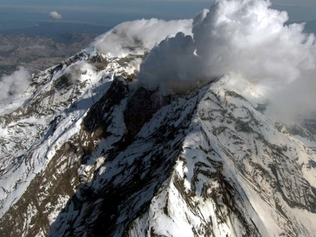 |
Figure 22. View of the face of Redoubt taken on 2 July 2009. Courtesy of AVO/USGS and Cyrus Read. |
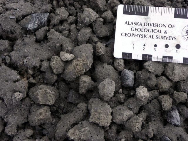 |
Figure 23. Redoubt fall deposit laid down on 23 March 2009. Taken at station RDW-C in July 2009. Courtesy of AVO/ADGGS and Kate Bull. |
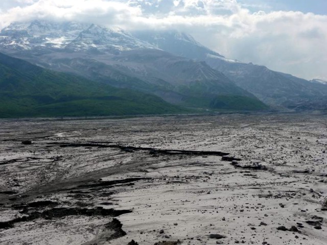 |
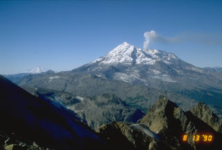
Figure 24. View looking towards Redoubt, 1 July 2009. Courtesy of the AVO/ADGGS and Kate Bull. |
Alaska Volcano Observatory (AVO) reported seismicity from Redoubt during 13 May to 23 June 2009 remained above background levels. Signals disclosed rock avalanches, discrete earthquakes. Minor volcanic tremor continued. Growth of the lava dome in the summit crater (figure 25) continued, and by 15 May the dome's volume was an estimated 30-60 million cubic meters. By 12 June, the dome was an estimated 1 km long, 460 m wide, and 200 m high. AVO warned that the unstable lava dome could fail with little or no warning, leading to significant ash emissions and possible lahars in the Drift River valley. Occasional rockfalls originating from unstable slopes of the lava dome produced minor ash clouds near the summit.
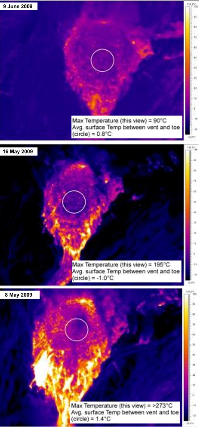 |
Figure 25. A series of Forward Looking InfraRed (FLIR) thermal images showing the Redoubt dome's gradual cooling. The new dome has been extruding since 4 April 2009. Temperature scales are at right. Note the average temperature of the rubbly area between the vent at the top of the dome and the block top at the N base of the dome (circle) varied between -1.0 to 1.4°C. Courtesy of AVO/USGS and Rick Wessles. |
Vigorous steam emissions from the margins of the lava dome were seen on the web camera. At times, incandescence was observed in nighttime images. During an overflight on 16 May, scientists observed a turquoise lake along the S margin of the dome, and a hot, vigorous, persistent fumarole on the W wall of the upper gorge.
By late June 2009, AVO reported declining seismicity. The lower seismicity and gas emissions, along with occasional observations, suggested that dome growth had significantly slowed. On 30 June, AVO lowered the Alert Level to Advisory and the Aviation Color Code to Yellow.
Aviation encounter on 26 March 2009. The Montreal VAAC received news that a plane for a Canadian carrier encountered a volcanic cloud over southern British Columbia, near Kelowna, at approximately 0000 UTC on 26 March 2009. At that time, to the best knowledge of the VAAC, the plume from the initial eruption of Redoubt (23 March) consisted of considerable amounts of SO2, but no ash. A full inspection of the plane found no ash.
Geological Summary. Redoubt is a glacier-covered stratovolcano with a breached summit crater in Lake Clark National Park about 170 km SW of Anchorage. Next to Mount Spurr, Redoubt has been the most active Holocene volcano in the upper Cook Inlet. The volcano was constructed beginning about 890,000 years ago over Mesozoic granitic rocks of the Alaska-Aleutian Range batholith. Collapse of the summit 13,000-10,500 years ago produced a major debris avalanche that reached Cook Inlet. Holocene activity has included the emplacement of a large debris avalanche and clay-rich lahars that dammed Lake Crescent on the south side and reached Cook Inlet about 3,500 years ago. Eruptions during the past few centuries have affected only the Drift River drainage on the north. Historical eruptions have originated from a vent at the north end of the 1.8-km-wide breached summit crater. The 1989-90 eruption had severe economic impact on the Cook Inlet region and affected air traffic far beyond the volcano.
Information Contacts: Alaska Volcano Observatory (AVO), a cooperative program of a) U.S. Geological Survey, 4200 University Drive, Anchorage, AK 99508-4667, USA (URL: http://www.avo.alaska.edu/), b) Geophysical Institute, University of Alaska, PO Box 757320, Fairbanks, AK 99775-7320, USA, and c) Alaska Division of Geological & Geophysical Surveys, 794 University Ave., Suite 200, Fairbanks, AK 99709, USA; Associated Press (URL: http://www.ap.org/); Dov Bensimon, Montréal VAAC, 2121 North Service Road, Trans-Canada Highway, Dorval, Quebec H9P 1J3, Canada.