Report on Erta Ale (Ethiopia) — July 2009
Bulletin of the Global Volcanism Network, vol. 34, no. 7 (July 2009)
Managing Editor: Richard Wunderman.
Erta Ale (Ethiopia) Changes at NW and S pit craters between 2002 and 2009
Please cite this report as:
Global Volcanism Program, 2009. Report on Erta Ale (Ethiopia) (Wunderman, R., ed.). Bulletin of the Global Volcanism Network, 34:7. Smithsonian Institution. https://doi.org/10.5479/si.GVP.BGVN200907-221080
Erta Ale
Ethiopia
13.601°N, 40.666°E; summit elev. 585 m
All times are local (unless otherwise noted)
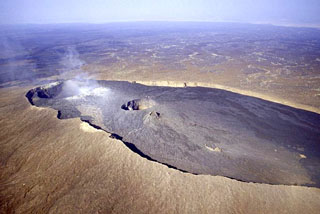
From 7-10 February 2009, an expedition team with Chris Weber visited Erta Ale (figure 22) and observed the long-active lava lake in the S pit crater. Although there have been intervening visits and reports (most recently from February 2008, BGVN 33:06), a comparison of observations from 2002 with 2008-2009 gives a sense of the changes to the craters (table 2).
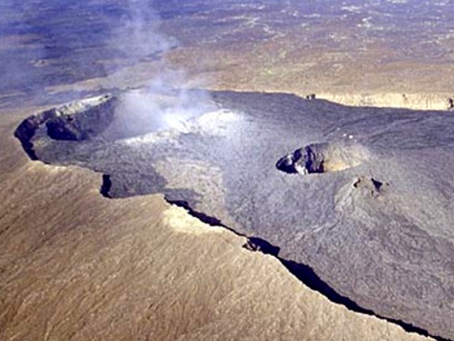 |
Figure 22. Aerial photograph of the summit of Erta Ale volcano, viewed from the S in February 2002. The summit contained a 0.7 x 1.6 km elliptical caldera housing two steep-sided craters. Steam rose from the NW pit crater (left), and a lava lake resided in the S pit crater (right). A hornito is just S of the S pit crater. Courtesy of Jürg Alean. |
Table 2. Summary of observations made during 2002, 2008,and 2009 of Erta Ale S and NW pits and lava lakes. The numbered terraces (former lake surfaces that chilled sufficiently to leave a conspicuous ledge) are shown on the sketch maps (figure 23). The undated 2008 observations came from the local guide, Meles Matwose. Courtesy of C. Weber.
| Date | South Crater | South Lava Lake | NW Crater | NW Lava Flows |
| 04 Dec 2002 | Elliptical (terraces 1 and 2) ~160 m EW, ~130 m NS. Two levels (terraces 1 and 2). About half the area (terrace 1) covered by basalt on terrace ~45 m below pit rim. | About half the area (terrace 2) ~100 m EW. Lake surface ~90 m below W rim of pit. | One level (terrace 3). | -- |
| 2008 | -- | -- | Massive collapse early in year caused new, deeper level (terrace 4). | Lava flows covered part of terraces 3 and 4. Latest flow in Nov 2008. |
| 07-10 Feb 2009 | Elliptical shape (terraces 1, 2, and the lava lake) ~190 m EW, ~150 m NS. Three levels (terraces 1, 2, lava lake). Terrace (terrace 1) and 2002 lava lake edge (terrace 2) ~35 m below W side of pit rim. | Lava lake ~60 m wide in W half of pit. Lake surface higher than in 2002 and it oscillated ~5 m vertically and at times came close to overflowing terraces 1 and 2. | Three levels (terraces 3, 4, and 5). | -- |
South pit crater. The active S pit expanded due to crater collapse on its W side between 2002 and 2009 (figure 23). The shape of the ellipsoidal crater increased by ~ 30 m EW and ~ 20 m NS.
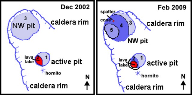 |
Figure 23. Sketch maps for part of Erta Ale comparing GPS surveys from December 2002 and February 2009. Data from 2002 courtesy of L. Fitsch (BGVN 28:04). Courtesy of C. Weber. |
The former lava-lake stand from 2002 left a remnant surface still visible in 2009 (terrace #2), an area marked as well by fractures and fumaroles. In both 2002 and 2009 terraces #1 and #2 still remained, separated by an elevation difference of ~ 40 m (BGVN 28:04).
During 2009, the W half of the S pit contained a 60 m wide active lava lake (figure 24). Fountaining there took place a few times per day, occasionally throwing spatter above the top of the crater walls. Some recent spatter was seen at the pit's W edge.
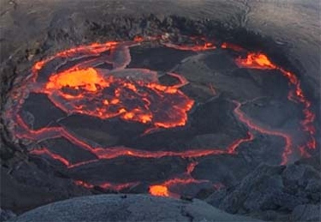 |
Figure 24. The active S crater lava lake in February 2009, with the molten lake surface at a much higher level than during November 2002, sometimes rising close to the terraces #1 and #2. The surface is approximately 35 m below the crater rim. Courtesy of C. Weber. |
NW pit crater. In February 2009 the NW crater had preserved ledges at three levels (terraces #3, #4, and #5). This represented a substantive change in comparison to 2002 where only level #3 was observed (figure 11). According to Weber, a local guide (Meles Matwose) reported that the NW crater had a massive collapse in early 2008, establishing the deeper level #4. Lava flows covering the crater floor occurred at that time, as well as new lava flows at level #4. One of the latest lava flows, observed by Matwose in November 2008, covered a part of a new interior plateau at level #4. When the lava lake stood at the lowest level, #5, very little lava entered the NW crater.
During the February 2009 expedition, some hornitos on level #4 degassed vigorously inside the pit crater, and, on 9 February 2009, lava spattered ~ 15 m high associated with Strombolian emissions ejected at one hornito during 1800 to 2200 hours. Many photos taken inside the Erta Ale craters in January-February 2009 are shown on the Volcano Discovery website.
Films of Erta Ale. Marc Szeglat's Streaming Planet website provides some spectacular film taken December 2002 inside the S pit showing eruptive activity and researchers collecting data. Cameraman and author of the film was Szeglat, and the film narration is in German. Another short film by Szeglat taken in February 2008 is shown on his YouTube channel.
Recent research publication. Spampinato and others (2008) noted that active lava lakes represent the exposed, uppermost part of convecting magma systems and provide windows into the dynamics of magma transport and degassing. They reported on the main features of the lava lake surface in the S pit of Erta Ale based on observations from an infrared thermal camera made on 11 November 2006. Efficient magma circulation was reflected in the sustained transport of the surface, which was composed of pronounced incandescent cracks that separated wide plates of cooler crust. These crossed the lake from the upwelling to the down-welling margin with mean speeds ranging between 0.01 and 0.15 m/s. Hot spots eventually opened in the middle of crust plates and/or along cracks. These produced mild explosive activity lasting commonly between ~ 10 and 200 s. Apparent temperatures of cracks ranged between ~ 700 and 1070°C, and those of crust between ~ 300 and 500°C.
Reference. Spampinato, L., Oppenheimer, C., Calvari, S., Cannata, A., and Montalto, P., 2008, Lava lake surface characterization by thermal imaging: Erta 'Ale volcano (Ethiopia), Geochemistry Geophysics Geosystems, v. 9, issue Q12008, doi:10.1029/2008GC002164.
Geological Summary. The Erta Ale basaltic shield volcano in Ethiopia has a 50-km-wide edifice that rises more than 600 m from below sea level in the Danakil depression. The volcano includes a 0.7 x 1.6 km summit crater hosting steep-sided pit craters. Another larger 1.8 x 3.1 km wide depression elongated parallel to the trend of the Erta Ale range is located SE of the summit and is bounded by curvilinear fault scarps on the SE side. Basaltic lava flows from these fissures have poured into the caldera and locally overflowed its rim. The summit caldera usually also holds at least one long-term lava lake that has been active since at least 1967, and possibly since 1906. Recent fissure eruptions have occurred on the N flank.
Information Contacts: Christoph Weber, Volcano Expeditions International (VEI), Muehlweg 11, 74199, Entergruppenbach, Germany (URL: http://www.volcanic-hazards.de/); Hawai'i Institute of Geophysics and Planetology (HIGP) Thermal Alerts System, School of Ocean and Earth Science and Technology (SOEST), Univ. of Hawai'i, 2525 Correa Road, Honolulu, HI 96822, USA (URL: http://modis.higp.hawaii.edu/); Streaming Planet (URL: http://www.streaming-planet.de/); Marc Szeglat (URL: http://www.youtube.com/marcszeglat and http://www.vulkane.net/); Volcano Discovery (URL: http://www.volcanodiscovery.com/); Jürg Alean, Kantonsschule Zürcher Unterland, Bülach, Switzerland.