Report on Rumble III (New Zealand) — July 2009
Bulletin of the Global Volcanism Network, vol. 34, no. 7 (July 2009)
Managing Editor: Richard Wunderman.
Rumble III (New Zealand) Submarine summit craters underwent collapse and eruption
Please cite this report as:
Global Volcanism Program, 2009. Report on Rumble III (New Zealand) (Wunderman, R., ed.). Bulletin of the Global Volcanism Network, 34:7. Smithsonian Institution. https://doi.org/10.5479/si.GVP.BGVN200907-241130
Rumble III
New Zealand
35.745°S, 178.478°E; summit elev. -220 m
All times are local (unless otherwise noted)
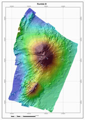
GNS Science in New Zealand issued a press release on 12 March 2009 reporting that scientists have returned from exploring submarine volcanoes in the Kermadec arc, where they found evidence of a recent large eruption at Rumble III (figure 2). While mapping the volcano aboard the University of Washington research vessel Thomas G. Thompson on 11 March 2009, they found that marked changes had occurred in the bathymetry of the summits and ash deposits there since their previous visit in 2007. The base of the volcano sits at a depth of 1.4 km.
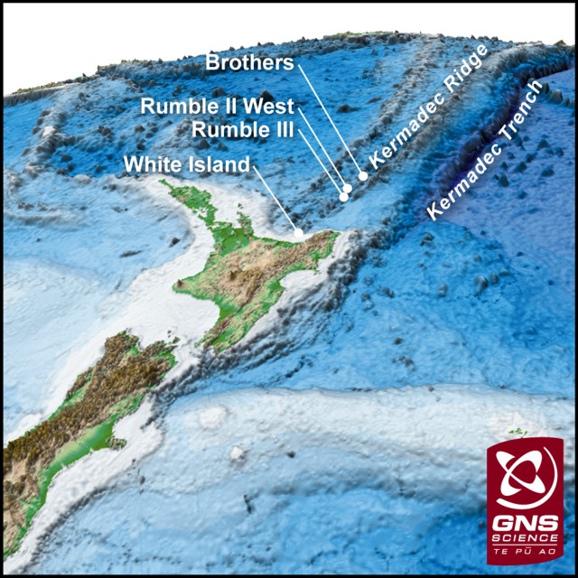 |
Figure 2. Map showing the location of Rumble III and other submarine volcanoes along the southern Kermadec arc. Rumble III volcano is located ~ 350 km NE of the Bay of Plenty, New Zealand, and is one of a number of submarine volcanoes that delineate the active arc front in this region. Courtesy of GNS Science (12 March 2009 press release). |
A 2007 bathymetric map prepared by GNS Science showed an 800-m-wide crater near the top of Rumble III. The map, made aboard the RV Thompson in 2009, showed that this crater has been in-filled and a nearby summit cone had been reduced in height by ~ 100 m. "This suggests there has been a major eruption that collapsed the summit cone and filled the adjacent crater," said Co-Chief Scientist on the voyage, Cornel de Ronde of GNS Science. He also stated that the date of collapse was not known.
According to the same report, images taken by a WHOI underwater camera towed by the research ship showed strewn lava boulders covered by black volcanic ash near the summit. Consistent with the lowering of the summit, de Ronde noted that hydrothermal plumes emanating from the summit vents were more vigorous than observed previously. In addition, some new and deeper vents were discovered.
Olivier Hyvernaud looked for acoustic (T-wave) signals recorded by the French Polynesian network that may have originated from Rumble III. He reported that the Laboratoire de Géophysique in Tahiti did not see any acoustic events from that location.
Geological Summary. Rumble III seamount, the largest of the Rumbles group of submarine volcanoes along the South Kermadec Ridge, rises 2,300 m from the seafloor to within about 200 m of the surface. Collapse of the edifice produced a scarp open to the west and a large debris-avalanche deposit. Fresh-looking andesitic rocks have been dredged from the summit and basaltic lava from its flanks. It has been the source of several submarine eruptions detected by hydrophone signals.
Information Contacts: GNS Science, Wairakei Research Centre, Private Bag 2000, Taupo 3352, New Zealand (URL: http://www.gns.cri.nz/); Cornel de Ronde, GNS Science (URL: http://www.gns.cri.nz/); Olivier Hyvernaud, Laboratoire de Géophysique, Commissariat a l'Energie Atomique (CEA/DASE/LDG), PO Box 640, Papeete, Tahiti, French Polynesia.