Report on Suwanosejima (Japan) — July 2009
Bulletin of the Global Volcanism Network, vol. 34, no. 7 (July 2009)
Managing Editor: Richard Wunderman.
Suwanosejima (Japan) Explosive eruptions continue through 6 July 2009
Please cite this report as:
Global Volcanism Program, 2009. Report on Suwanosejima (Japan) (Wunderman, R., ed.). Bulletin of the Global Volcanism Network, 34:7. Smithsonian Institution. https://doi.org/10.5479/si.GVP.BGVN200907-282030
Suwanosejima
Japan
29.638°N, 129.714°E; summit elev. 796 m
All times are local (unless otherwise noted)
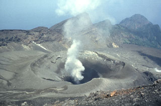
This small uninhabited island, one of Japan's most active volcanoes, lies ~ 175 km SSW of Kyushu Island. Previous reports on Suwanose-jima (BGVN 30:07, 32:11, 33:02, and 33:09) listed ash plumes between 28 April 2004 and 26 October 2008. This report continues the compilation through 6 July 2009 (table 8). Ash plumes were consistent and minor, below ~ 2.5 km altitude.
Table 8. A summary of Tokyo Volcanic Ash Advisory Center (VAAC) reports on explosive events and ash plumes from Suwanose-jima, 29 October 2008 to 6 July 2009. For some events, observers detected an explosion but were unable to observe a plume (indicated by --). Courtesy of Tokyo VAAC, based on information from the Japanese Meteorological Agency (JMA), pilot reports, and satellite imagery.
| Date (UTC) | Plume Altitude (km) | Drift Direction |
| 29-30 Oct 2008 | 1.5-1.8 | E |
| 31 Oct-01 Nov 2008 | -- | -- |
| 03 Nov 2008 | 1.5-1.8 | E |
| 05 Nov 2008 | 1.5 | NE |
| 07 Nov-08 Nov 2008 | 1.2-1.8 | E |
| 12 Nov-16 Nov 2008 | -- | -- |
| 13 Nov-15 Nov 2008 | 1.5-2.1 | -- |
| 21 Nov 2008 | 1.5 | E |
| 25 Nov 2008 | -- | -- |
| 10 Dec-12 Dec 2008 | 0.9-1.8 | E |
| 14 Dec-17 Dec 2008 | 0.9-1.8 | E |
| 19 Dec-20 Dec 2008 | 1.5 | E (17, 19 Dec) |
| 26 Dec-28 Dec 2008 | 1.5-1.8 | -- |
| 30 Dec 2008 | -- | -- |
| 03 Jan 2009 | 1.2 | E |
| 09 Jan 2009 | -- | -- |
| 21 Jan 2009 | -- | -- |
| 18 Feb 2009 | 0.4 | -- |
| 19 Feb-21 Feb 2009 | -- | -- |
| 26 Feb-02 Mar 2009 | 1.2-1.5 | E (1 Mar) |
| 03 Mar 2009 | -- | -- |
| 06 Mar 2009 | -- | -- |
| 15 Mar-16 Mar 2009 | 1.5 | E (15 Mar) |
| 28, 30 Mar 2009 | -- | -- |
| 06, 8, 10 Apr 2009 | -- | -- |
| 21 Apr 2009 | -- | -- |
| 22 Apr-23 Apr 2009 | 1.2-1.5 | E, S |
| 27 Apr 2009 | -- | -- |
| 28 Apr-01 May 2009 | 1.5-1.8 | E, W |
| 07-09, 12-13 May 2009 | -- | -- |
| 17 May 2009 | 2.1 | -- |
| 25 May 2009 | 1.5 | -- |
| 16 Jun 2009 | -- | -- |
| 06 Jul 2009 | -- | -- |
Yukio Hayakawa passed along quantitative data on the explosive eruption on 18 February 2009. The maximum amplitude of ground velocity computed from the analog data was expressed in units of 10-5 m/s (in Japan this unit is expressed as mkine). The values on the 18th were 5.38 x 10⁻⁵ m/s; and the airwave was 11 Pa. Hayakawa also indicated that the two explosive eruptions on 20 February had maximum amplitudes of 4.31 x 10⁻⁵ m/s and 5.76 x 10⁻⁵ m/s, respectively. The airwaves recorded were 20 and 18 Pa, respectively at microphones.
A visible-wavelength image from MODIS captured a small Suwanose-jima plume on 5 July 2009 (figure 13). As of mid-2009, no thermal alerts had been recorded by MODVOLC since 22 September 2008. The island is often covered by clouds, thwarting detection.
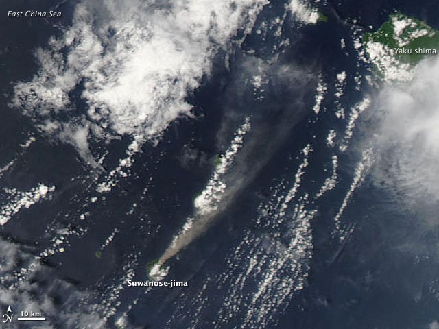 |
Figure 13. Image of Suwanose-jima taken on 5 July 2009 by the Moderate Resolution Imaging Spectroradiometer (MODIS) on NASA's Aqua satellite. A beige-colored plume fans out and remains conspicuous for ~ 18 km to the NE blowing toward the island of Yaku-shima. Courtesy of NASA Earth Observatory and the US Air Force Weather Agency. |
Geological Summary. The 8-km-long island of Suwanosejima in the northern Ryukyu Islands consists of an andesitic stratovolcano with two active summit craters. The summit is truncated by a large breached crater extending to the sea on the E flank that was formed by edifice collapse. One of Japan's most frequently active volcanoes, it was in a state of intermittent Strombolian activity from Otake, the NE summit crater, between 1949 and 1996, after which periods of inactivity lengthened. The largest recorded eruption took place in 1813-14, when thick scoria deposits covered residential areas, and the SW crater produced two lava flows that reached the western coast. At the end of the eruption the summit of Otake collapsed, forming a large debris avalanche and creating an open collapse scarp extending to the eastern coast. The island remained uninhabited for about 70 years after the 1813-1814 eruption. Lava flows reached the eastern coast of the island in 1884. Only about 50 people live on the island.
Information Contacts: Tokyo Volcanic Ash Advisory Center (VAAC), Tokyo, Japan (URL: http://ds.data.jma.go.jp/svd/vaac/data/); Japan Meteorological Agency (JMA), Otemachi, 1-3-4, Chiyoda-ku Tokyo 100-8122, Japan (URL: http://www.jma.go.jp/); U.S. Air Force Weather Agency (AFWA)/XOGM, Offutt Air Force Base, NE 68113, USA; Hawai'i Institute of Geophysics and Planetology (HIGP) Thermal Alerts System, School of Ocean and Earth Science and Technology (SOEST), Univ. of Hawai'i, 2525 Correa Road, Honolulu, HI 96822, USA (URL: http://modis.higp.hawaii.edu/); Yukio Hayakawa, Gunma University, Faculty of Education, Aramaki 4-2, Maebashi 371-8510, Japan.