Report on Uzon (Russia) — July 2009
Bulletin of the Global Volcanism Network, vol. 34, no. 7 (July 2009)
Managing Editor: Richard Wunderman.
Uzon (Russia) Valley of Geysers two years after the major landslide of June 2007
Please cite this report as:
Global Volcanism Program, 2009. Report on Uzon (Russia) (Wunderman, R., ed.). Bulletin of the Global Volcanism Network, 34:7. Smithsonian Institution. https://doi.org/10.5479/si.GVP.BGVN200907-300170
Uzon
Russia
54.4885°N, 159.9741°E; summit elev. 1617 m
All times are local (unless otherwise noted)
Our previous report on the Valley of Geysers (BGVN 32:07) discussed a major landslide on 3 June 2007 that seriously damaged the landscape and destroyed several beautiful geysers. Scientists again visited the area about two years after the landslide. One of the geysers that was a few meters underwater returned to life after the confining lake waters dropped below the geyser's rim.
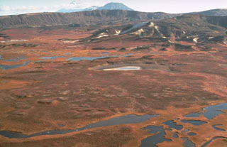
The following report came chiefly from Vladimir L. Leonov and his son, A.V. Leonov, who wrote an informal description of events (Leonov, 2008). The S-trending Valley of Geysers cuts radially across the topographic margin of the Geysernaya caldera at the SE end of the Uzon-Geysernaya caldera complex (figure 9).
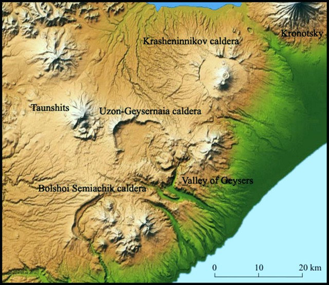 |
Figure 9. A relief map showing a portion of Kamchatka's Eastern volcanic front near Uzon. The various calderas are surrounded by thick ignimbrite sheets. Uzon caldera sits to the W of and alongside the neighboring Geysernaia (Geysernaya) caldera to the E. The Geysernaya caldera is cut across its SE margin by the Valley of Geysers, a famous hydrothermal field. The field was partly buried in 2007 by a landslide that dammed the river descending the Valley (Geysernaya River, BGVN 32:07). In contrast to Uzon's flat floor, Geysernaya caldera contains abundant (dominantly Pleistocene) lava domes. This map was created by the Shuttle Radar Topography Mission (SRTM) and released by NASA/JPL/NIMA. |
As previously reported, the landslide created a dam on the Geysernaya River, forming a lake. According to Leonov (2008), the lake surface rose to a maximum elevation of 435 m on 7 June 2007, before eroding, causing a rapid decline in water level to 426 m elevation.
During July and August 2007, the Emergency and Disaster Relief Ministry and volunteers deepened the new bed of the Geysernaya River by hand to lower the lake level by another 2 m, thus freeing the Bolshoi geyser vent from the cover of lake water. After these efforts, on 19 September 2007, the Bolshoi geyser revived and erupted for the first time since the 2007 landslide.
When studied in October 2008, the Bolshoi geyser (figure 10) responded to minor fluctuations of the water level in the lake. Bolshoi was seen to operate in either the regime of a geyser or in the regime of a pulsating source. When the water was low, the geyser regime was seen. With the rise of water of only about 10-15 cm (as a result rains or the melting of snow ) the water began to pour out of Bolshoi's vent in episodic pulsations.
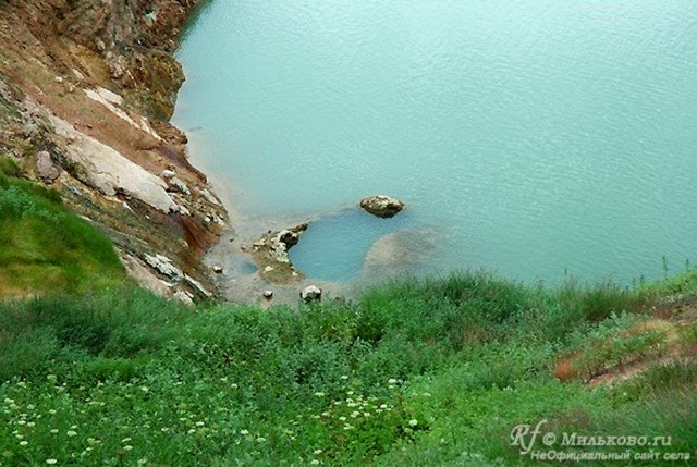 |
Figure 10. The Bolshoi geyser after the lake's water level had decreased 11 m from the maximum level seen earlier. The basin (vent area) of the geyser is still slightly submerged but the rim is in places out of the water. Copyrighted photo from September 2007; courtesy of Milkovo. |
The thickest section of landslide completely covered the 30-m waterfall at Vodopadny Creek (a branch of the Geysernaya River), and the geysers Troynoi (Triple), Sakharny (Sugary), and Sosed (Neighbor) (figures 11 and 12).
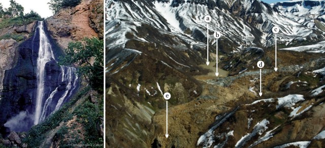 |
Figure 11. (right) Annotated aerial photo of the middle part of the landslide along the Geysernaya River looking NE as taken by Dmitry Zadirey (Kamchatka Airlines) on 5 June 2007. The landslide flowed from upper right towards lower left. Features are as follows: a) landslide-dammed lake; b) the dam; c) the site of buried waterfall along Vodopadny Creek; d) the buried geysers Triple, Sugary, and Neighbor; e) the Gate into the Valley of Geysers (also shown in figure 12). (left) Pre-landslide view of the the waterfall along Vodopadny Creek (copyrighted photo by Igor Katkov, 2004). From Leonov (2008). |
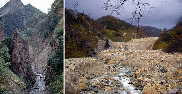 |
Figure 12. The Gate into Valley of Geysers (left) seen before the landslide with steep canyon walls (copyrighted photo by Igor Katkov, 2004) and (right) the area after burial by the landslide (photo by Vladimir Leonov, October 2008). From Leonov (2008). |
Reference. Leonov, A.V., 2008, Valley of Geysers 500 days later; (URL: http://spanishflyer.livejournal.com/39861.html); accessed on 6 July 2009.
Geological Summary. The Uzon and Geysernaya calderas, containing Kamchatka's largest geothermal area, form a 7 x 18 km depression that originated during multiple mid-Pleistocene eruptions. Widespread ignimbrite deposits associated with caldera formation have a volume of 20-25 km3 (exclusive of airfall deposits) and cover an area of 1,700 km2. Post-caldera activity was largely Pleistocene in age and consisted of the extrusion of small silicic lava domes and flows and maar formation in the Geysernaya caldera. The Lake Dal'ny maar in the NE part of the 9 x 12 km western Uzon caldera is early Holocene in age, and several Holocene phreatic eruptions have been documented in the Geysernaya caldera. The extensive high-temperature hydrothermal system includes the many hot springs, mudpots, and geysers of the Valley of Geysers, a 4-km-long canyon on the SE margin of the depression. Hydrothermal explosions took place in the caldera in 1986 and 1989.
Information Contacts: Vladimir L. Leonov, Institute of Volcanology and Seismology FED RAS, Far East Division, Russian Academy of Sciences, Piip Ave. 9, Petropavlovsk-Kamchatsky 683006, Russia (URL: http://www.kscnet.ru/ivs/kvert/); Milkovo (URL: http://www.milkovo.ru/); Dmitry Zadirey, Air Company Kamchatka Airlines, Yelizovo, Russia.