Report on Rabaul (Papua New Guinea) — August 2009

Bulletin of the Global Volcanism Network, vol. 34, no. 8 (August 2009)
Managing Editor: Richard Wunderman.
Rabaul (Papua New Guinea) Modest earthquakes and ash plumes since mid-December 2008
Please cite this report as:
Global Volcanism Program, 2009. Report on Rabaul (Papua New Guinea) (Wunderman, R., ed.). Bulletin of the Global Volcanism Network, 34:8. Smithsonian Institution. https://doi.org/10.5479/si.GVP.BGVN200908-252140
Rabaul
Papua New Guinea
4.2459°S, 152.1937°E; summit elev. 688 m
All times are local (unless otherwise noted)
This report updates our discussion of Rabaul caldera's behavior after mid-December 2008 (BGVN 33:11). Following the large 1994 eruption (Blong and McKee, 1995; Blong, 2003; Nairn and others, 1995), the ongoing eruptions have been focused at one vent along the caldera's E side at the Tavurvur cone.
Between mid-December 2008 and 30 September 2009, minor eruptions at Tavurvur continued a period of intermittent activity that began in August 2006 (BGVN 31:02). Characteristic activity during this interval consisted of intermittent emissions of ash plumes and less frequent explosions sometimes ejecting incandescent lava fragments.
During mid-December 2008 through January 2009, earthquakes were weak to moderate, but increased to moderate to high in March before decreasing again after 10 April. The earthquakes were dominated by events associated with ash emissions.
Ground deformation measurements by GPS and tide gauge stations registered deflation during mid-December 2008 through mid-March 2009, sometimes with modest uplift. The water-tube tiltmeter data showed a modest down-tilt toward the caldera. In mid-March deflation slowed and then ceased. Deformation was stable until September 2009, when deflation increased slightly.
According to the Rabaul Volcano Observatory (RVO), during much of the above 10-month period, white plumes and gray ash plumes from Tavurvur rose a few hundred to several thousand meters above the crater. Glow was seen most nights and incandescent tephra was ejected.
RVO reported that, on 11 January, two small vents opened one-quarter of the way up the SW flank of Tavurvur and began to emit ash. Ash emissions from the volcano ranged from occasional to sustained over long periods during mid-December 2008 through April 2009 and, during this period, light-to-moderate ash fell on nearby communities, including Rabaul town (3-5 km NW). During 5-9 January 2009 ashfall caused Air Niugini to suspend all its flights to Tokua airport (about 20 km SE) and, according to a news article, a local shipping company offered to take up to 400 passengers to an airport in New Ireland Province, an area not affected by the ash plumes. In May through July, the amount of ashfall decreased, and periods of no ash were noted, but ashfall again increased somewhat in September. A MODIS satellite image of an ash plume was taken on 28 August 2009 (figure 50).
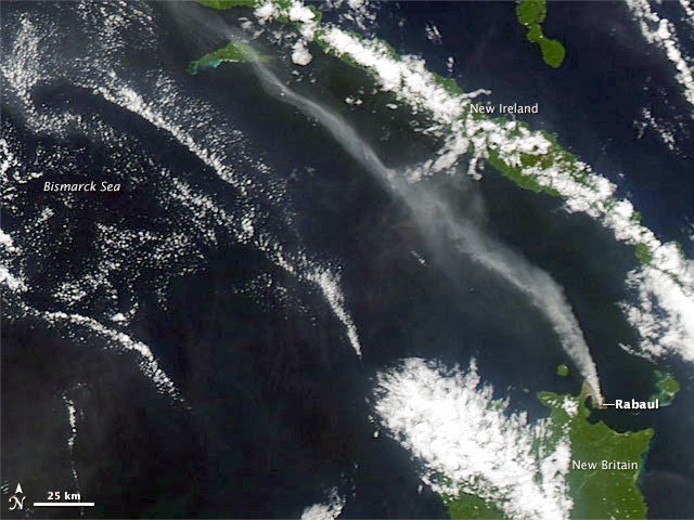 |
Figure 50. Rabaul volcano on the island of New Britain released a plume of ash and/or steam on 28 August 2009, as the Moderate Resolution Imaging Spectroradiometer (MODIS) on NASA's Aqua satellite captured this true-color image. The volcanic plume blews NW. Unlike the nearby clouds, the plume is slightly darker in color, with more diffuse outlines. Courtesy of NASA Earth Observatory. |
Although the weather often precludes satellite observations, the combination of reports from the Darwin Volcanic Ash Advisory Centre (VAAC) and the RVO can be tabulated to provide a sense of the ongoing activity (table 11).
Table 11. Ranges of ash plume altitudes and drift directions from Rabaul's Tavuvur cone between 10 December 2008 and 18 September 2009. A similar table was presented for the period 1 May-10 December 2008 in BGVN 33:11. Data courtesy of RVO and the Darwin VAAC.
| Date | Plume Altitude | Plume Direction | Plume Distances | Notes |
| 10 Dec-26 Dec 2008 | 1.7-3 km | NE, ENE, ESE, SE, W | -- | Gray ash, roaring noises, explosions, incandescent lava ejections. |
| 30 Dec-30 Jan 2009 | 1.7-2.4 km | W, NW, NNW, N, NE, SE, SW | -- | Gray ash. |
| 14 Jan-03 Feb 2009 | 1.7-3 km | N, NE, SE, SW | -- | Gray ash. |
| 04 Feb-23 Feb 2009 | 1.8-3 km | SE, S, W, NW | -- | -- |
| 02 Mar-26 Mar 2009 | 1-3 km | N, NW, SE | -- | White and gray ash; blue vapor visible between ash emissions. |
| 27 Mar-26 Apr 2009 | 0.5-3 km | S, SW, SE, NW, NE, W | 35-120 km | White with occasional gray or brown plumes. |
| 27 Apr-20 May 2009 | 2.4-3 km | NE, E, SE, SW | 30-40 km | Pale gray ash, white with occasional blue plumes. |
| 21 May-21 Jun 2009 | 1-4.3 km | S, E, SE, NW | 20-75 km | Pale gray ash, white with occasional blue plumes. |
| 22 Jul-02 Sep 2009 | 1.5-3 km | N, E, NW, SW, S | 25-280 km | -- |
| 04 Sep-18 Sep 2009 | 1.5-2.4 km | N, NW | 35-260 km | Gray ash and white plumes; ashfall in Rabaul town (3-5 km NW). |
MODVOLC satellite thermal alerts were common at Tavurvur during the year ending 7 October 2009. Alerts during this interval sometimes occurred multiple times per day but with frequent gaps of days, and in one case, about a month. A similar pattern was noted during 16 November to 23 July 2007 (BGVN 32:06 and 29:06).
References. Blong, R. and McKee, C., 1995, The Rabaul eruption 1994: Destruction of a town: National Hazards Research Center, Macquarie University, Australia.
Blong, R., 2003, Building damage in Rabaul, Papua New Guinea, 1994: Bull. Volc., v. 65, no. 1 [ISSN 0258-8900 (Print) 1432-0819 (Online)]
Nairn, I.A., McKee, C.O., Talai, B. and Wood, C.P., 1995, Geology and eruptive history of the Rabaul Caldera area, Papua New Guinea: Jour. Volcanol. Geotherm. Res., v. 69, p. 255?284.
Geological Summary. The low-lying Rabaul caldera on the tip of the Gazelle Peninsula at the NE end of New Britain forms a broad sheltered harbor utilized by what was the island's largest city prior to a major eruption in 1994. The outer flanks of the asymmetrical shield volcano are formed by thick pyroclastic-flow deposits. The 8 x 14 km caldera is widely breached on the east, where its floor is flooded by Blanche Bay and was formed about 1,400 years ago. An earlier caldera-forming eruption about 7,100 years ago is thought to have originated from Tavui caldera, offshore to the north. Three small stratovolcanoes lie outside the N and NE caldera rims. Post-caldera eruptions built basaltic-to-dacitic pyroclastic cones on the caldera floor near the NE and W caldera walls. Several of these, including Vulcan cone, which was formed during a large eruption in 1878, have produced major explosive activity during historical time. A powerful explosive eruption in 1994 occurred simultaneously from Vulcan and Tavurvur volcanoes and forced the temporary abandonment of Rabaul city.
Information Contacts: Rabaul Volcano Observatory (RVO), P.O. Box 386, Rabaul, Papua New Guinea; Darwin Volcanic Ash Advisory Centre (VAAC), Bureau of Meteorology, Northern Territory Regional Office, PO Box 40050, Casuarina, NT 0811, Australia (URL: http://www.bom.gov.au/info/vaac/); Hawai'i Institute of Geophysics and Planetology (HIGP) Thermal Alerts System, School of Ocean and Earth Science and Technology (SOEST), Univ. of Hawai'i, 2525 Correa Road, Honolulu, HI 96822, USA (URL: http://modis.higp.hawaii.edu/); NASA Earth Observatory (URL: http://earthobservatory.nasa.gov/).