Report on Koryaksky (Russia) — September 2009
Bulletin of the Global Volcanism Network, vol. 34, no. 9 (September 2009)
Managing Editor: Richard Wunderman.
Koryaksky (Russia) Continued ash emissions during May-September 2009
Please cite this report as:
Global Volcanism Program, 2009. Report on Koryaksky (Russia) (Wunderman, R., ed.). Bulletin of the Global Volcanism Network, 34:9. Smithsonian Institution. https://doi.org/10.5479/si.GVP.BGVN200909-300090
Koryaksky
Russia
53.321°N, 158.712°E; summit elev. 3430 m
All times are local (unless otherwise noted)
During March-18 April 2009 (BGVN 34:03) seismicity and volcanism continued at Karymsky, and ash plumes were detected for hundreds of kilometers. This report discusses the interval May-October 2009, with some discussion of earlier seismicity. The key conclusion for this new interval is that seismicity has not stopped and occasional, though smaller ash plumes continued.
In the mid-May 2009 volcanic and seismic activity decreased considerably. The active fumarole on the NW slope produced gas-steam plumes, but no longer contained appreciable ash (figure 8).
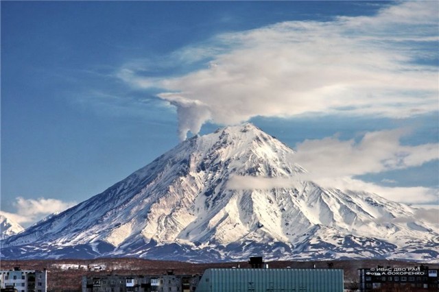 |
Figure 8. Gas-steam emission seen on the NW side Koryaksky on 11 May 2009. The white snow on the volcano confirms the virtual absence of any ash in the plume. Photo by A. Socorenko. |
On 2-3 June 2009, observers again saw small areas of snow that were dark gray, indicating some increased ash content. On 15-16 August 2009 instruments began to register a spasmodic volcanic tremor; seismicity increased, and on 17 August ash fell to the SW, forming a deposit 1 mm thick (figure 9).
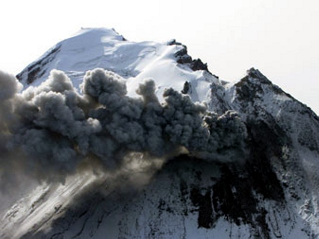 |
Figure 9. Ash plume from a vent on NW slope of Koryaksky. Snow on the slope covered fresh ashfall. Dark area around vent is due to local heating and melting of snow cover. Photo taken on 18 August 2009 by S. Chirkov. |
Seismic analysis. Seliverstov (2009) analyzed seismicity for May 2008 to 10 June 2009, looking at events larger than Ks 4 (Class 4 earthquakes, roughly those larger than M ~ 1.2) and found a spatial and temporal pattern to this stronger seismicity. During March 2008 a prominent swarm of earthquakes was often centered at about 5-10 km depth. Smaller earthquakes were also seen around that time, several at ~ 12 km depth, and some at 15 km depth. This stronger seismicity then waned for several months until late June. During August 2008 to 10 June 2009, earthquakes were numerous, often centered near 5 km depth.
Figure 10 shows a representative set of hypocenters during 3 January 2009-6 November 2009. The pattern shown was similar to that seen during various months during 2008 through mid-2009. Other patterns during 2008 to mid-2009 included intervals where epicenters dipped, as noted in the analysis presented by Seliverstov (2009). Despite decreased volcanic activity, the elevated seismicity remained until at least 10 June 2009.
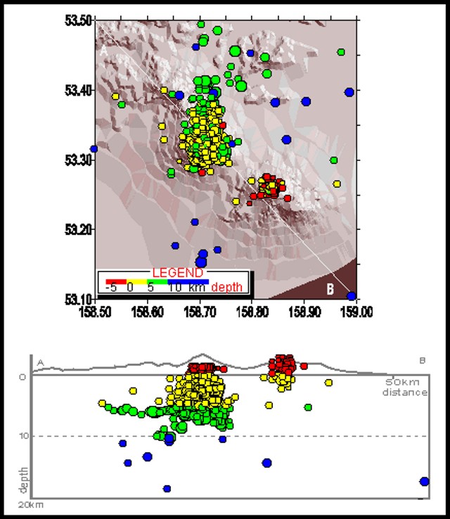 |
Figure 10. Seismicity of Koryaksky (and Avachinsky, to the SE) recorded during May-October 2009. Map shows location and depths of earthquakes (white line is cross-section AB. Cross-section shows hypocenters within 20 km depth. Courtesy of the Kamchatka Branch of the Geophysical Service, Russian Academy of Sciences (KB GS RAS). |
The number of earthquakes recorded within 10-15 km of the summit during January through October 2009 by the KB GS RAS peaked in April with 422 events, and again in August with 245 events. Otherwise, the interval commonly had monthly totals of 100-200 with the lowest during January (59 events) and October (37 events).
References. Seliverstov, N., 2009, The activity Koryaksky volcano, Kamchatka, Vestnik KRAUNC, Earth Science Series; Petropavlovsk-Kamchatsky, 2009, v. 13, p.7-9 [ISSN 1816-5524]. In Russian.
Geological Summary. The large symmetrical Koryaksky stratovolcano is the most prominent landmark of the NW-trending Avachinskaya volcano group, which towers above Kamchatka's largest city, Petropavlovsk. Erosion has produced a ribbed surface on the eastern flanks of the 3430-m-high volcano; the youngest lava flows are found on the upper W flank and below SE-flank cinder cones. Extensive Holocene lava fields on the western flank were primarily fed by summit vents; those on the SW flank originated from flank vents. Lahars associated with a period of lava effusion from south- and SW-flank fissure vents about 3900-3500 years ago reached Avacha Bay. Only a few moderate explosive eruptions have occurred during historical time, but no strong explosive eruptions have been documented during the Holocene. Koryaksky's first historical eruption, in 1895, also produced a lava flow.
Information Contacts: Kamchatka Volcanic Eruptions Response Team (KVERT), Far East Division, Russian Academy of Sciences, 9 Piip Blvd., Petropavlovsk-Kamchatsky, 683006, Russia (URL: http://www.kscnet.ru/ivs/); Kamchatka Branch of the Geophysical Service of the Russian Academy of Sciences (KB GS RAS), Sergey Senukov, Russia (URL: http://www.emsd.ru/); Alexander Socorenko and Sergei Chirkov, IV&S FED RAS; Tokyo Volcanic Ash Advisory Center (VAAC), Tokyo, Japan (URL: http://ds.data.jma.go.jp/svd/vaac/data/).