Report on Karkar (Papua New Guinea) — November 2009

Bulletin of the Global Volcanism Network, vol. 34, no. 11 (November 2009)
Managing Editor: Richard Wunderman.
Karkar (Papua New Guinea) Tall November 2009 plumes from meteorological effects
Please cite this report as:
Global Volcanism Program, 2009. Report on Karkar (Papua New Guinea) (Wunderman, R., ed.). Bulletin of the Global Volcanism Network, 34:11. Smithsonian Institution. https://doi.org/10.5479/si.GVP.BGVN200911-251030
Karkar
Papua New Guinea
4.647°S, 145.976°E; summit elev. 1839 m
All times are local (unless otherwise noted)
No information about activity at Karkar has been included in reports from the Rabaul Volcano Observatory (RVO) since December 2007 (BGVN 33:03) when there were roaring noises and gas emissions from the Bagai cone. Ash advisories were issued to aviators on 25-26 November 2009 based on satellite analyses, but ground observers did not see any activity. Later interpretations were that some increased activity from the volcano, but not an explosive eruption, caused the plume formation seen in satellite imagery. Such reports do occur at times due to the limited ability to rapidly communicate with some remote locations, and where operational agencies must issue warnings on short notice for safety reasons.
Satellite observations. The Darwin Volcanic Ash Advisory Center (VAAC) interpreted satellite imagery taken at 1132 (0132 UTC) on 25 November 2009 as showing an ash plume rising to an altitude of 13.7 km before merging with a thunderstorm to the W an hour later (figure 7). Although this activity was not noticed immediately, it was seen during an imagery review later in the day; an ash advisory was issued at 1839 (0839 UTC) and RVO was notified. Another eruption was reported the next morning at 0832 (2232 UTC, 25 November), with an ash plume to 9.1 km altitude, based on analysis of MTSAT-1R satellite data. Meteorological clouds prevented additional observations.
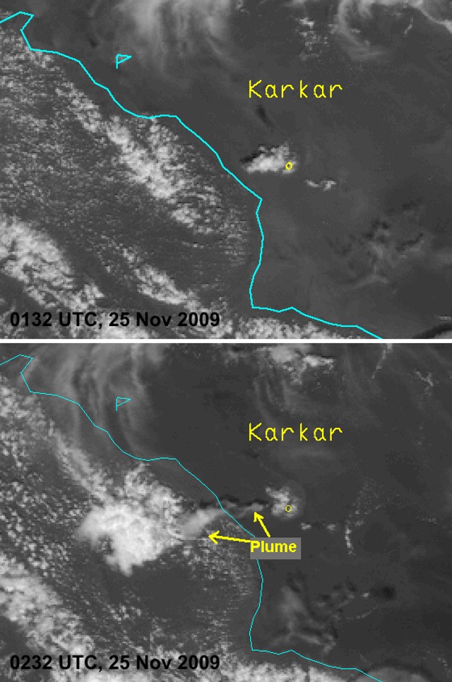 |
Figure 7. Visible satellite imagery of Karkar on 25 November 2009 showing a convective cloud over the volcano at 1132 (0132 UTC), and a plume-like structure W of the island at 1232 (0232 UTC). Satellite image originally processed by the Australian Bureau of Meteorology from the geostationary satellite MTSAT-1R, operated by the Japan Meteorological Agency. Courtesy of the Darwin VAAC. |
Rebecca Patrick and Andrew Tupper provided the following as context for the issuance of an ash advisory in situations like this, as follows: "Explosive eruptions have often occurred in the region with virtually identical satellite signatures, so it is difficult to change VAAC practice and we apologise for any false alarms of highly explosive eruptions. The only way to reduce these without also reducing the probability of detection is to effectively link ground-based monitoring with remote sensing observations, and Darwin and Rabaul have been working cooperatively towards that [end].
"One of the scenarios that Darwin VAAC often deals with is that lower-level volcanic activity is thought to be able to trigger deep meteorological convection in the right moist and conditionally unstable environment, which is present for much of the year in our part of the tropics (deep meteorological convection in the tropics regularly ascends to 15-18 km). The 'volcanic thunderstorms' described by Oswalt and others (1994) following the Pinatubo eruption [where rising heat from the vent and deposits created vertical instability to trigger local storms after the eruption] are the best known example of this and were examined further by Tupper and others (2005, 2009). Depending on the size of the eruption, such clouds may or may not contain measurable amounts of volcanic material.
"Based on the repeated genesis of convection from the summit of Karkar, resulting in the plume-like structure seen on the imagery, the observations kindly relayed by Rabaul Volcano Observatory suggesting mild volcanic activity but no eruption, and analysis of the remote sensing data, we believe the most likely explanation on this occasion is that deep meteorological convection was generated by mild volcanic activity at Karkar, and the clouds created had no measurable ash content."
Ground observations reported by government officials. After being informed by a telephone call from the Darwin VAAC of a possible eruption at Karkar, the Rabaul Volcano Observatory attempted, without success, to obtain confirmation from people on Karkar Island. Communication was established with the District Administrator (DA), who was visiting Madang Town. The DA reported that his family had described no unusual events when he talked to them around 1800 that evening, and instructed one of his officers to inspect around the island later that night.
When reports were received between 0800 and 0900 on the morning of 26 November there was no indication of an eruption; there was no glow, no audible noises, and no reported ashfall. However, that morning a villager in Mom did report seeing dense white to gray vapor in the active crater area. Apparently the volume of vapor had increased almost a week earlier, following a felt earthquake. Additional information received by RVO a couple of days later indicated dead vegetation S of the active crater; similar observations had been made in late 2007. The only unusual observation was a couple of new 'holes' in the crater area, but no clear descriptions of the holes were given.
Ground observations reported by local residents. In a 4 December posting on his blog site, as well as commentary on "The Volcanism Blog" and the "Eruptions" blog, Jan Messersmith provided valuable eye-witness observations from his vantage point in Madang, ~ 60 km SSW of Karkar, where he had a direct view of the volcano from his home. Messersmith had seen no activity, though the volcano was slightly obscured by clouds, after being notified by a friend in Port Moresby that a large ash eruption was reportedly underway. He spoke with friends on the island by telephone on 26 November and they reported no activity. On 28 November Messersmith viewed Karkar from a boat located ~ 50 km from the volcano, but also saw no signs of activity. Nobody in the area was reporting an eruption, despite boats traveling to and from the island.
However, during several weeks in either April or May 2009, Messersmith had seen what appeared to be steam emissions, along with a brownish atmospheric stratification of gas or very fine ash that stretched for many kilometers downwind.
References. Oswalt, J. S., Nichols, W., and O'Hara, J.F., 1996, Meteorological observations of the 1991 Mount Pinatubo eruption, in Fire and Mud: eruptions and lahars of Mount Pinatubo, Philippines, C. G. Newhall and R. S. Punongbayan (eds.): Philippines Institute of Volcanology and Seismology & University of Washington Press, p. 625-636.
Tupper, A., Oswalt, J.S., and Rosenfeld, D., 2005, Satellite and radar analysis of the volcanic-cumulonimbi at Mt Pinatubo, Philippines, 1991: Journal of Geophysical Research, v. 110, doi:10.1029/2004JD005499.
Tupper, A., Textor, C., Herzog, M., Graf, H.-F., and Richards, M., 2009, Tall clouds from small eruptions: the sensitivity of eruption height and fine ash content to tropospheric instability: Natural Hazards, v. 51, p. 375-401.
Geological Summary. Karkar is a 19 x 25 km forest-covered island that is truncated by two nested summit calderas. The 5.5 km outer caldera was formed during one or more eruptions, the last of which occurred 9,000 years ago. The steep-walled 300-m-deep, 3.2 km diameter, inner caldera was formed sometime between 1,500 and 800 years ago. Cones are present on the N and S flanks of this basaltic-to-andesitic volcano; a linear array of small cones extends from the northern rim of the outer caldera nearly to the coast. Recorded eruptions date back to 1643 from Bagiai, a pyroclastic cone constructed within the inner caldera, the floor of which is covered by young, mostly unvegetated andesitic lava flows.
Information Contacts: Ima Itikarai, Rabaul Volcano Observatory (RVO), P.O. Box 386, Rabaul, Papua New Guinea; Rebecca Patrick and Andrew Tupper, Darwin Volcanic Ash Advisory Centre (VAAC), Bureau of Meteorology, Northern Territory Regional Office, PO Box 40050, Casuarina, NT 0811, Australia (URL: http://www.bom.gov.au/info/vaac/); Jan Messersmith, Madang - Ples Bilong Mi (URL: http://www.messersmith.name/wordpress/); The Volcanism Blog (URL: http://volcanism.wordpress.com/); Eruptions (URL: http://scienceblogs.com/eruptions/).