Report on Bagana (Papua New Guinea) — November 2009

Bulletin of the Global Volcanism Network, vol. 34, no. 11 (November 2009)
Managing Editor: Richard Wunderman.
Bagana (Papua New Guinea) Intermittent ash plumes through November 2009; active lava flow
Please cite this report as:
Global Volcanism Program, 2009. Report on Bagana (Papua New Guinea) (Wunderman, R., ed.). Bulletin of the Global Volcanism Network, 34:11. Smithsonian Institution. https://doi.org/10.5479/si.GVP.BGVN200911-255020
Bagana
Papua New Guinea
6.137°S, 155.196°E; summit elev. 1855 m
All times are local (unless otherwise noted)
The eruptive activity at Bagana that began in September 2000 continued through late 2009. As previously reported, lava flows and ash emissions occurred during 2008 through at least mid-December (BGVN 33:03 and 33:11). Similar activity, confirmed by visual observations and satellite data, continued through the end of 2009.
Based on analysis of satellite imagery, the Darwin VAAC reported ash plumes on 17 and 29-31 December 2008. Intermittent ash plumes continued to be reported throughout 2009 based on both satellite imagery and visual observations (table 4). Thermal anomalies identified in MODIS data (figure 10) were also intermittent throughout 2009. The frequency and number of daily alert pixels was higher during 1 June-10 August.
Table 4. Ash plumes from Bagana seen on satellite imagery or by visual observations during 2009. Courtesy of the Darwin VAAC and RVO.
| Date | Plume Altitude | Drift Directions | Remarks |
| 17 Dec 2008 | 3 km | W | -- |
| 29 Dec 2008 | -- | W | Extended 75 km |
| 30 Dec 2008 | 2.4 km | NW | -- |
| 31 Dec 2008 | 2.4 km | -- | -- |
| 26 Apr 2009 | 2.4 km | S | Extended 28 km |
| 02 May 2009 | 3 km | NE | Extended 55 km |
| 04 May 2009 | 2.4 km | NE | Extended 45 km |
| 02 Jun 2009 | 2.4 km | W | Extended 75 km |
| 27 Jun 2009 | 2.4 km | SW | Extended 110 km |
| 19 Jul 2009 | 1.8 km | NW | Extended 100 km |
| 20 Jul 2009 | -- | -- | Dense gray ash clouds |
| 26 Jul 2009 | -- | -- | Dense gray ash clouds |
| 30 Jul 2009 | -- | -- | Dense gray ash clouds |
| 10 Aug 2009 | 3 km | NW | Diffuse ash plume extended 55 km |
| 19 Aug 2009 | 2.1 km | W | Extended 90 km |
| 09 Sep 2009 | -- | -- | Light-gray ash emissions |
| 10 Sep 2009 | -- | -- | Light-gray ash emissions |
| 12 Sep 2009 | 2.4 km | NW | Extended 37 km |
| 13 Sep 2009 | 2.4 km | W | Extended 65 km |
| 16 Sep 2009 | -- | -- | Light-gray ash emissions |
| 17 Sep 2009 | 2.4 km | W, SW | Extended 46 km |
| 18 Sep 2009 | 2.4 km | SW, NW | Extended 37 km |
| 19 Sep 2009 | 2.4 km | NW | Extended 28 km |
| 09 Oct 2009 | 2.4 km | SW | Extended 45 km |
| 15 Oct 2009 | 2.1 km | SW | Extended 55 km |
| 12 Nov 2009 | 3 km | SW | Extended 65 km |
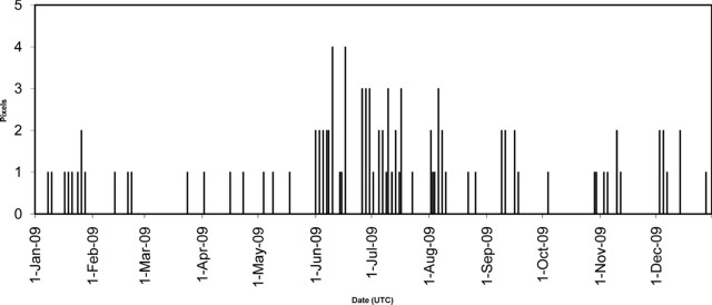 |
Figure 10. Maximum number of daily thermal alert pixels at Bagana as identified by the MODVOLC system during 2009. Data comes from MODIS instruments on both Aqua and Terra satellites; the total shown is the maximum pixels per satellite per pass on a given day (UTC). Courtesy of Hawai'i Institute of Geophysics and Planetology (HIGP) Thermal Alerts System. |
Activity continued at a low level during February 2009 with white vapor emissions from the summit. Occasional loud booming noises were heard between 6 and 13 February. Collapses from the edge of an active lava flow resulted in glowing lava fragments moving down the SW flank that were visible at night on 7 February.
During April both the Main Crater and the Northwest Vent released moderate volumes of white vapor. The emissions from Northwest Vent ceased on 14 April. A single moderately loud booming noise was heard on 23 April from the Main Crater. Intermittent ash plumes extending in various directions were reported by the Darwin VAAC on 26 April, on 2 and 4 May, and again on 2 and 27 June.
July 2009 emissions from the summit crater consisted of white vapor. Single loud booming noises were heard on 15, 16, and 20 July. An ash plume reported by the Darwin VAAC extended 100 km NW on 19 July, and RVO noted dense gray ash clouds on 20, 26, and 30 July. A weak glow was visible on most nights during the month. The lava flow was reported active only on 1 July, when collapses from the leading edge resulted in rapid movement of glowing lava fragments on the SW flank.
During August the Darwin VAAC reported ash plumes on the 10th and 19th. RVO noted that the summit was obscured by atmospheric clouds throughout the first week of September. After that it was clear on most days until the end of October. Activity consisted of dense white emissions, except for 9, 10, and 16 September when small amounts of light gray ash were released. Occasional weak glow was observed on the 9th, but moderately bright glow was seen during 16, 19, 21, and 26 September. More ash plumes were seen in satellite imagery during 12-13 and 17-19 September.
Glow was observed on 3 October, which seems to have been associated with the dislodging of lava fragments from the active flow. Discrete booming noises were heard on 2, 4, and 9 October. The Darwin VAAC reported ash plumes on 9 and 15 October, and 12 November.
Geological Summary. Bagana volcano, in a remote portion of central Bougainville Island, is frequently active. This massive symmetrical cone was largely constructed by an accumulation of viscous andesitic lava flows. The entire edifice could have been constructed in about 300 years at its present rate of lava production. Eruptive activity is characterized by non-explosive effusion of viscous lava that maintains a small lava dome in the summit crater, although occasional explosive activity produces pyroclastic flows. Lava flows with tongue-shaped lobes up to 50 m thick and prominent levees descend the flanks on all sides.
Information Contacts: Rabaul Volcano Observatory (RVO), PO Box 386, Rabaul, Papua New Guinea; Darwin Volcanic Ash Advisory Centre (VAAC), Bureau of Meteorology, Northern Territory Regional Office, PO Box 40050, Casuarina, NT 0811, Australia (URL: http://www.bom.gov.au/info/vaac/); Hawai'i Institute of Geophysics and Planetology (HIGP) Thermal Alerts System, School of Ocean and Earth Science and Technology (SOEST), Univ. of Hawai'i, 2525 Correa Road, Honolulu, HI 96822, USA (URL: http://modis.higp.hawaii.edu/).