Report on Batur (Indonesia) — November 2009
Bulletin of the Global Volcanism Network, vol. 34, no. 11 (November 2009)
Managing Editor: Richard Wunderman.
Batur (Indonesia) September 2009 seismic increase after over 8 years of quiet
Please cite this report as:
Global Volcanism Program, 2009. Report on Batur (Indonesia) (Wunderman, R., ed.). Bulletin of the Global Volcanism Network, 34:11. Smithsonian Institution. https://doi.org/10.5479/si.GVP.BGVN200911-264010
Batur
Indonesia
8.2403°S, 115.3775°E; summit elev. 1711 m
All times are local (unless otherwise noted)
The Center of Volcanology and Geological Hazard Mitigation (CVGHM) reported that seismicity at Batur (figure 3) increased from September 2009 to 7 November 2009, and the number of earthquakes increased significantly on 8 November (table 3). During this period, sulfurous plumes were ejected from the craters. The Alert Level was raised to 2 (on a scale of 1-4). This seismic activity was the first noted at Batur since 2001, when a series of mild earthquakes occurred (BGVN 26:09).
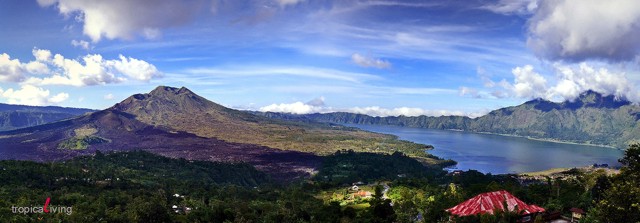 |
Figure 3. Panorama of Batur caldera showing the ~ 7-km-long lake in the SE part of the caldera along with the cental topographic high composed of intracaldera cones. Copyrighted photo courtesy of "tropicaLiving" taken on 9 April 2008. |
Table 3. Number of different types of earthquakes registered at Batur between September 2009 and 8 November 2009. *Through 1830 local time on 8 November. Data from CVGHM.
| Date | Deep volcanic | Shallow volcanic | Low-frequency |
| Sep 2009 | 21 | 11 | 13 |
| Oct 2009 | 28 | 20 | 15 |
| 01 Nov-07 Nov 2009 | 12 | 7 | 7 |
| 88 Nov 2009* | 5 | 53 | -- |
Geological Summary. The historically active Batur is located at the center of two concentric calderas NW of Agung volcano. The outer 10 x 13.5 km caldera was formed during eruption of the Bali (or Ubud) Ignimbrite about 29,300 years ago and now contains a caldera lake on its SE side, opposite the Gunung Abang cone, the topographic high of the complex. The inner 6.4 x 9.4 km caldera was formed about 20,150 years ago during eruption of the Gunungkawi Ignimbrite. The SE wall of the inner caldera lies beneath Lake Batur; Batur cone has been constructed within the inner caldera to a height above the outer caldera rim. The Batur stratovolcano has produced vents over much of the inner caldera, but a NE-SW fissure system has localized the Batur I, II, and III craters along the summit ridge. Recorded eruptions have been characterized by mild-to-moderate explosive activity sometimes accompanied by lava emission. Basaltic lava flows from both summit and flank vents have reached the caldera floor and the shores of Lake Batur in historical time.
Information Contacts: Center of Volcanology and Geological Hazard Mitigation (CVGHM), Jalan Diponegoro 57, Bandung 40122, Indonesia (URL: http://vsi.esdm.go.id/); tropicaLiving (URL: http://www.flickr.com/photos/tropicaliving/).