Report on Mayon (Philippines) — December 2009

Bulletin of the Global Volcanism Network, vol. 34, no. 12 (December 2009)
Managing Editor: Richard Wunderman.
Mayon (Philippines) December 2009 eruption causes evacuation of more than 47,000 people
Please cite this report as:
Global Volcanism Program, 2009. Report on Mayon (Philippines) (Wunderman, R., ed.). Bulletin of the Global Volcanism Network, 34:12. Smithsonian Institution. https://doi.org/10.5479/si.GVP.BGVN200912-273030
Mayon
Philippines
13.257°N, 123.685°E; summit elev. 2462 m
All times are local (unless otherwise noted)
After erupting in September and November 2009 (BGVN 34:10), monitoring of Mayon by the Philippine Institute of Volcanology and Seismology (PHIVOLCS) continued. Renewed eruptions began on 14 December 2009 with ash columns reaching as high as 1,000 m above the summit, incandescent materials rolling downslope from the crater, and a lava flow descending SE from the summit (table 11). More than 47,000 people were ordered to evacuate for nearly three weeks (figure 16), requiring them to abandon homes and farms (figure 17). International news attention was acute, highlighting evacuations, the volcano's grandeur, and glow over substantial areas in long-exposure night photos.
Table 11. Daily summaries of observations reported at Mayon, including seismicity, SO2 emission rates, and other observations (including Alert Levels) during 14 December 2009-12 January 2010. Numbers of events represent counts from the seismic monitoring network over a 24-hour period prior to the stated reporting date/time (except as noted). Rockfall events are related to the detatchment of fresh lava fragments at the volcano's upper slopes. Ash explosions and other observation are based on actual sightings. SO2 emission rates, measured by FLYSPEC, are for the day before the reporting date. Courtesy of PHIVOLCS.
| Report Date (local time) | Volcanic earthquakes and rockfalls | Ash explosions | SO2 flux (t/d) | Observations |
| 14 Dec 2009 (2000) | VE: 23(0800-1600) | 6 (3 minutes at 0704) | 535 | Ash columns (gray to brown) to 1 km above summit, drifting WSW and WNW; incandescent materials rolling downslope ~3 km towards Bonga, Buyuan, Mabinit channels. Alert Level raised to 3. |
| 15 Dec 2009 (0800) | VE: 83 | -- | 757 | Incandescent lava fragments from summit crater rolling downslope ~3 km. |
| 16 Dec 2009 (0800) | VE: 78 | -- | 750 | Lava front (~700-800 m from summit) and incandescent fragments ~3-4 km along Bonga gully. |
| 18 Dec 2009 (0700) | VE: 248 | 7 | 1,065 | Dark gray to dark brown ash columns up to 1 km above summit, drifting SW; crater glow. |
| 19 Dec 2009 (0700) | VE: 197 | 15 | 2,034 | 18 volcanic earthquakes; white to grayish ash columns up to 2 km above summit, drifting SW; steam dirty white to light brown; crater glow, continuous rolling downslope of incandescent materials from crater. |
| 20 Dec 2009 (0700) | VE: 222 | -- | 7,024 | Dirty white to gray ash columns to 500 m above summit, drifting SW; crater glow, continuous rolling downslope of incandescent materials; lava flow ~4.5 km along Bonga-Buyuan gully; Alert Level raised to 4. |
| 21 Dec 2009 (0700) | VE: 1,942 | many | 6,089 | Intensified crater glow and rolling incandescent fragments from crater; lava flows along Bonga-Buyuan (to ~5 km from crater), Miisi, Lidong gullies; lava fountains rose ~200 m. |
| 22 Dec 2009 (0700) | VE: 1,266 | reported | 6,529 | Lava flows along Bonga-Buyuan (to ~5 km from crater), Miisi, Lidong gullies. |
| 23 Dec 2009 (0700) | VE: 1,051 | 66 | 6,737 | Ash columns (gray to light brown) to 1 km above summit, drifting SW; lava continuously flowed along Bonga-Buyuan, Miisi, Lidong gullies. |
| 24 Dec 2009 (0700) | VE: 815 | 21 | 5,737 | Ash columns to 1.5 km above summit; lava fountains reached 500 m; lava continuously flowed along Bonga-Buyuan, Miisi, Lidong gullies. |
| 25 Dec 2009 (0700) | VE: 871 RF: 98 | 96 | 2,738 | Ash columns (gray to light brown) up to 2 km above summit; three rockfall events generated pyroclastic flows that moved down ~2 km from crater. |
| 26 Dec 2009 (0700) | VE: 406 RF: 142 | 33 | 8,993 | Ash columns (dirty white to brownish) up to 1 km; lava and rolling incandescent fragments along Bonga-Buyuan, Miisi, Lidong gullies. |
| 27 Dec 2009 (0700) | VE: 44 RF: 297 | 9 | 2,304 | Ash columns (dirty white to brown) with lava fragments up to 800-1,000 m above summit; flowing lava and rolling incandescent lava fragments; edifice remained inflated. |
| 28 Dec 2009 (0700) | VE: 44 RF: 137 | 7 | 4,329 | Ash columns (dirty white to light gray) with lava fragments up to 2 km, drifting SW; lava flows along Bonga-Buyuan, Miisi, Lidong gullies; rolling incandescent fragments. |
| 29 Dec 2009 (0700) | VE: 38 RF: 171 | 9 | 3,416 | Ash columns (dirty white to brown) to 2 km, drifting W and SW; lava flowed along Bonga-Buyuan (to 5.8 km), Miisi, Lidong gullies; rolling incandescent fragments. |
| 30 Dec 2009 (0700) | VE: 16 RF: 150 | 1 | 4,397 | Dirty white ash column ~100 m, drifted NW; lava flowed along Bonga-Buyuan (to 5.9 km from summit), Miisi, Lidong gullies; volcanic edifice remained inflated in NE sector. |
| 31 Dec 2009 (0800) | VE: 60 RF: 267 | -- | 1,158 | Lava extrusion and rolling incandescent fragments along Bongo gully; white steam drifted WSW; volcanic edifice remained inflated in NE sector. |
| 01 Jan 2010 (0700) | VE: 28 RF: 91 | 0 | 1,255 | White steam drifted WSW; flowing lava and rolling incandescent lava fragments. |
| 02 Jan 2010 (0800) | VE: 13 RF: 68 | -- | 2,621 | White steam; Alert Level lowered to 3. |
| 03 Jan 2010 (0700) | VE: 9 RF: 30 | -- | 2,094 | -- |
| 04 Jan 2010 (0700) | VE: 7 RF: 33 | -- | -- | -- |
| 05 Jan 2010 (0700) | VE: 3 RF: 21 | -- | -- | -- |
| 06 Jan 2010 (0700) | VE: 4 RF: 21 | -- | 1,914 | White steam; pale glow from crater at night. |
| 07 Jan 2010 (0700) | VE: 20 RF: 20 | -- | 672 | White steam from summit crater. |
| 08 Jan 2010 (0700) | VE: 5 RF: 29 | -- | 1,077 | -- |
| 09 Jan 2010 (0700) | VE: 5 RF: 20 | -- | 1,345 | Glow from crater at night. |
| 10 Jan 2010 (0700) | VE: 8 RF: 12 | -- | 759 | White steam from summit crater; pale glow from crater at night. |
| 11 Jan 2010 (0700) | VE: 4 RF: 18 | -- | -- | White steam from summit crater, reaching 300-500 m above crater rim, drifting WSW; pale glow from crater at night. |
| 12 Jan 2010 (0700) | VE: 6 RF: 17 | -- | 820 | White steam from summit crater; pale glow from crater at night; ground deformation at Buang and Lidong level lines showed deflation compared to 2 December 2009 survey. |
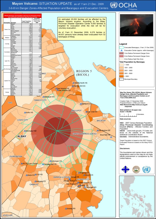 |
Figure 16. A Mayon map variously showing volcanic hazard (3-, 6-, and 8-km radius danger zones), evacuation centers, Albay Province census data (shaded areas defined on legend), and the actual evacuated population (44,637 people). The locations evacuated (table at upper left) were within the 6-km Permanent Danger Zone and SE Quadrant High-Risk Zone (7-8 km radial distance) and came from eight municipalities and their 32 subdivisions (barangays). The table shows both the targeted number of evacuees and the actual number as of 1100 on 21 December. Courtesy of the United Nations OCHA, 21 December 2009. |
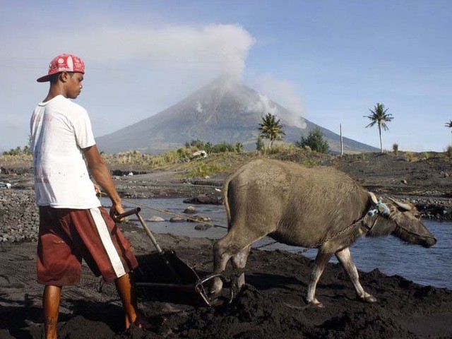 |
Figure 17. A farmer tills the soil while Mayon steams in the background. Many residents in threatened areas were reluctant to leave their homes and livestock. Date and photographer unknown. Courtesy of AFP. |
At the onset of the eruption, after a minor ash explosion at 0740 on 14 December, five more minor ash explosions occurred at the summit crater. These explosions produced brownish to grayish ash clouds which were blown by strong winds WSW and WNW. The explosions lasted for ~3 minutes and were registered on the seismograph as explosion earthquakes. Twenty-three volcanic earthquakes were also recorded from 0800 to 1600. During the morning of 14 December the sulfur dioxide (SO2) emission rate measured by FLYSPEC [a miniature, light-weight ultraviolet correlation spectrophotometer (Horton and others, 2006)] was 757 metric tons/day (t/d). At 1800, incandescent materials originating from the summit crater were seen rolling downslope SE ~3 km in the direction of Bonga, Buyuan, and Mabinit channels.
On 14 December 2009 PHIVOLCS raised the hazard status to Alert Level 3 (meaning that magma is close to the crater and a hazardous explosive eruption is possible). The alert was again raised, to Level 4 (meaning a hazardous explosive eruption is possible within days), on 20 December. After decreased activity the Alert was lowered to Level 3 on 2 January 2010.
Satellite observations and measurements. Figure 18 shows a satellite image of Mayon captured on 15 December 2009. NASA's Jesse Allen noted that "A small plume of ash and steam is blowing west from the summit. Dark-colored lava or debris flows from previous eruptions streak the flanks of the mountain. A ravine on the southeast slope is occupied by a particularly prominent lava or debris flow."
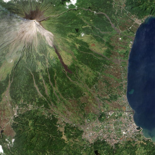 |
Figure 18. A natural-color image of Mayon taken 15 December 2009 (N to the top; for approximate scale, the distance from the summit to the coast is ~10 km). Image acquired by the Advanced Land Imager on NASA's Earth Observing-1 (EO-1) satellite. Courtesy of NASA. |
MODIS/MODVOLC satellite thermal alerts were measured nearly daily during 14-31 December 2009; alerts were absent after 31 December 2009 and at least as late as 12 January 2010. It is noted that during 3 passes of the MODIS satellite (on 24 December at 1715 UTC, 25 December at 1330 UTC, and 28 December at 1400 UTC), 11-pixel alerts occurred each pass that gave some idea of the area covered by the thermal anomaly. Prior to this period, alerts were measured only during an eruption of Mayon from 15 July-25 September 2006 (BGVN 31:07, 31:08, 32:05, and 34:02).
Evacuation. The alert status rose from Level 3 to 4 (on a scale of 1-5) on 20 December (table 11). According to a news article by Sophia Dedace at GMANews.TV on 14 January 2010, between 14 December and 2 January, the threatening eruption prompted the provincial government to evacuate more than 47,000 residents located within Mayon danger zones.
Reference. Horton, K.A., Williams-Jones, G., Garbeil, H., Elias, T., Sutton, A.J., Mouginis-Mark, P., Porter, J.N., and Clegg, S., 2006, Real-time measurement of volcanic SO2 emissions: validation of a new UV correlation spectrometer (FLYSPEC): Bull. Volc., v. 68, no. 4, p. 323-327 (doi:10.1007/s00445-005-0014-9).
Geological Summary. Symmetrical Mayon, which rises above the Albay Gulf NW of Legazpi City, is the most active volcano of the Philippines. The steep upper slopes are capped by a small summit crater. Recorded eruptions since 1616 CE range from Strombolian to basaltic Plinian, with cyclical activity beginning with basaltic eruptions, followed by longer periods of andesitic lava flows. Eruptions occur predominately from the central conduit and have also produced lava flows that travel far down the flanks. Pyroclastic density currents and mudflows have commonly swept down many of the approximately 40 ravines that radiate from the summit and have often damaged populated lowland areas. A violent eruption in 1814 killed more than 1,200 people and devastated several towns.
Information Contacts: Philippine Institute of Volcanology and Seismology (PHIVOLCS), Department of Science and Technology, University of the Philippines Campus, Diliman, Quezon City, Philippines (URL: http://www.phivolcs.dost.gov.ph/); Philippine Daily Inquirer (URL: http://www.inquirer.net/); Vox Bikol (URL: http://www.voxbikol.com/); Philippine Information Agency (URL: http://pia.gov.ph/); GMANews.TV, 6/F GMA Network Center, EDSA corner Timog Avenue, Diliman, Quezon City, 1101, PHILIPPINES (URL: http://www.gmanews.tv/index.html); Jesse Allen, NASA (URL: https://www.nasa.gov/), and MODIS/MODVOLC Thermal Alerts, Hawai'i Institute of Geophysics and Planetology (HIGP) Thermal Alerts System, School of Ocean and Earth Science and Technology (SOEST), Univ. of Hawai'i, 2525 Correa Road, Honolulu, HI 96822, USA (URL: http://modis.higp.hawaii.edu/); Agence France Presse (URL: http://www.afp.com/).