Report on Cleveland (United States) — December 2009
Bulletin of the Global Volcanism Network, vol. 34, no. 12 (December 2009)
Managing Editor: Richard Wunderman.
Cleveland (United States) At least three eruptions during 2009, with a possible fourth on 12 December
Please cite this report as:
Global Volcanism Program, 2009. Report on Cleveland (United States) (Wunderman, R., ed.). Bulletin of the Global Volcanism Network, 34:12. Smithsonian Institution. https://doi.org/10.5479/si.GVP.BGVN200912-311240
Cleveland
United States
52.825°N, 169.944°W; summit elev. 1730 m
All times are local (unless otherwise noted)
Cleveland, an Aleutian Islands volcano situated almost 1,500 km S of the E margin of the Bering strait, had multiple short-duration ash-bearing explosive eruptions in 2009. The first of these documented eruptions took place on 2 January 2009 (BGVN 33:11). The next two documented ash-bearing eruptions occurred on 25 June and 2 October 2009 (BGVN 34:10). As stated in those previous issues, thermal anomalies were common in satellite data as reported by the Alaskan Volcano Observatory (AVO).
Previously not reported was a possible fourth 2009 eruption, which took place on 12 December. It seemingly generated a diffuse ash plume, an event detected a few days later in satellite imagery (figure 7). AVO had also lowered the hazard status on 12 December to "Unassigned," a level that results from the lack of a nearby seismic receiver and the consequent inability to define background seismicity. As of late January 2010, further activity at Cleveland was absent and no further reports were issued.
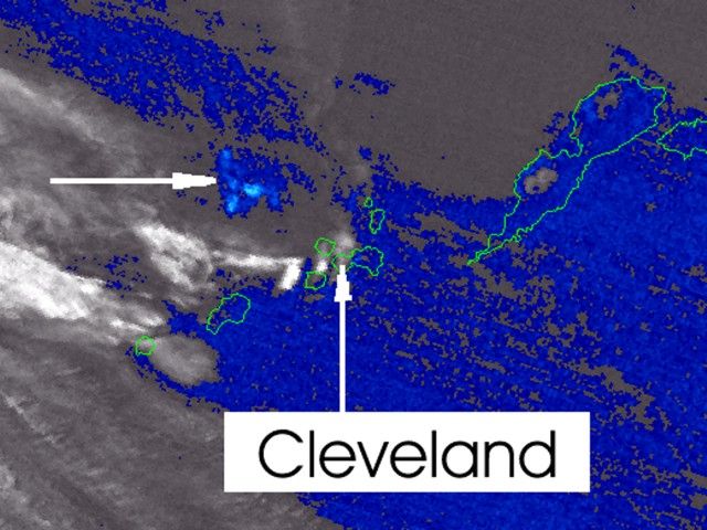 |
Figure 7. A MODIS satellite image of Cleveland volcano and vicinity captured at 2237 UTC on 12 December 2009 (brightness temperature difference from Channel 31 minus Channel 32). The plume (at tip of horizontal arrow) was judged as likely due to an eruption but this was not certain. N is towards the top and for approximate scale, the adjacent (Nikolski) island outlined to the E is ~100 km long (for other maps, see BGVN 33:07 and 26:01). Courtesy of John Dehn, AVO (arrows added). |
John Dehn of AVO provided more details regarding the discovery and interpretation of the 12 December plume (figure 7). It was initially detected by David J. Beberwyk at the Air Force Weather Agency (AFWA). The information was passed to AVO and distributed to staff on 14 December. After looking at the imagery, they announced in log entries on 15 December that they had possibly missed the faint signal in their daily reporting. Dehn was "pretty confident that this [was] real but the signal is comparable to weather systems."
Dehn went on to note that "Cleveland is known for these small events, and whether we catch them is up to the fortuitousness of a satellite pass and good weather. No further activity was reported, though [AVO's] Rick Wessels noted that a MODIS image from a few hours later shows possible dark deposits on the NW side of the summit. The summit of the volcano has typically had dark deposits on the snow in recent years as we've seen on the webcam, satellite imagery and observer reports so this [was] not conclusive."
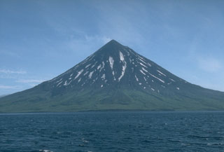
Geological Summary. The beautifully symmetrical Mount Cleveland stratovolcano is situated at the western end of the uninhabited Chuginadak Island. It lies SE across Carlisle Pass strait from Carlisle volcano and NE across Chuginadak Pass strait from Herbert volcano. Joined to the rest of Chuginadak Island by a low isthmus, Cleveland is the highest of the Islands of the Four Mountains group and is one of the most active of the Aleutian Islands. The native name, Chuginadak, refers to the Aleut goddess of fire, who was thought to reside on the volcano. Numerous large lava flows descend the steep-sided flanks. It is possible that some 18th-to-19th century eruptions attributed to Carlisle should be ascribed to Cleveland (Miller et al., 1998). In 1944 it produced the only known fatality from an Aleutian eruption. Recent eruptions have been characterized by short-lived explosive ash emissions, at times accompanied by lava fountaining and lava flows down the flanks.
Information Contacts: Alaska Volcano Observatory (AVO), a cooperative program of the U.S. Geological Survey, 4200 University Drive, Anchorage, AK 99508-4667, USA; Geophysical Institute, University of Alaska, PO Box 757320, Fairbanks, AK 99775-7320, USA; and Alaska Division of Geological & Geophysical Surveys, 794 University Ave., Suite 200, Fairbanks, AK 99709, USA (URL: http://www.avo.alaska.edu/).