Report on Erta Ale (Ethiopia) — January 2010
Bulletin of the Global Volcanism Network, vol. 35, no. 1 (January 2010)
Managing Editor: Richard Wunderman.
Erta Ale (Ethiopia) February 2010 visit reveals little change in South pit crater's lava lake since 2002
Please cite this report as:
Global Volcanism Program, 2010. Report on Erta Ale (Ethiopia) (Wunderman, R., ed.). Bulletin of the Global Volcanism Network, 35:1. Smithsonian Institution. https://doi.org/10.5479/si.GVP.BGVN201001-221080
Erta Ale
Ethiopia
13.601°N, 40.666°E; summit elev. 585 m
All times are local (unless otherwise noted)
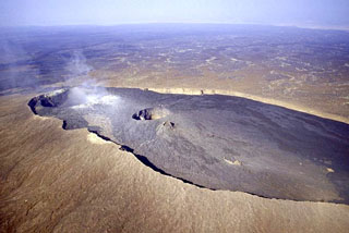
Christoph Weber sent a report about his 8-11 February 2010 visit to Erta Ale. We last reported on Erta Ale after a visit by Weber in February 2009 (BGVN 34:07). The volcano is famous for molten lava lakes.
Activity at the S pit crater was comparable to that noted in December 2002 (figure 25, also see BGVN 28:04). The elliptical pit crater measured ~ 180 m E-W and ~ 140 m N-S. The upper platform (terrace T) inside the crater was, on 10 February 2010, covered by a lava flow, and the lava lake surface was ~ 20 m below the W rim (figure 26). On 9 February the 65-m-wide active lake in the W half of the crater rose and overflowed the lower ring terraces. Fountaining at the lava lake took place most of the time during the observations (figure 27), occasionally higher than the pit crater walls. Fresh lava spatters were found at the S pit crater's W edge. A sample was taken out of the lava lake.
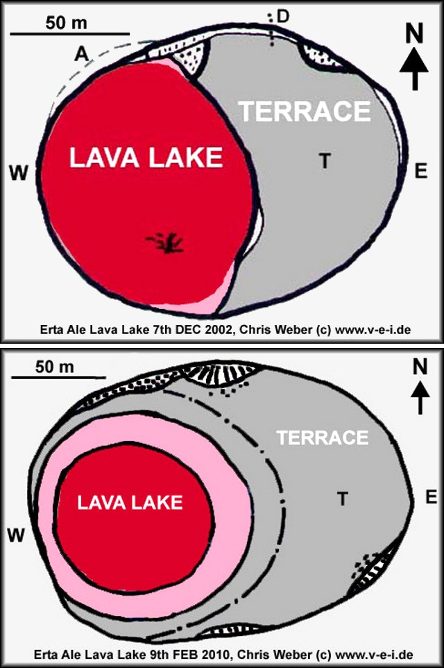 |
Figure 25. Sketch maps of the southern Erta Ale pit crater on 7 December 2002 and 9 February 2010. In 2002 the elliptical pit crater was ~ 160 m E-W and 130 m N-S. The lava lake (taking up ~ 50% of the crater) from E to W was ~ 100 m in diameter. In 2010 the crater was ~ 180 x 140 m. Courtesy of C. Weber. |
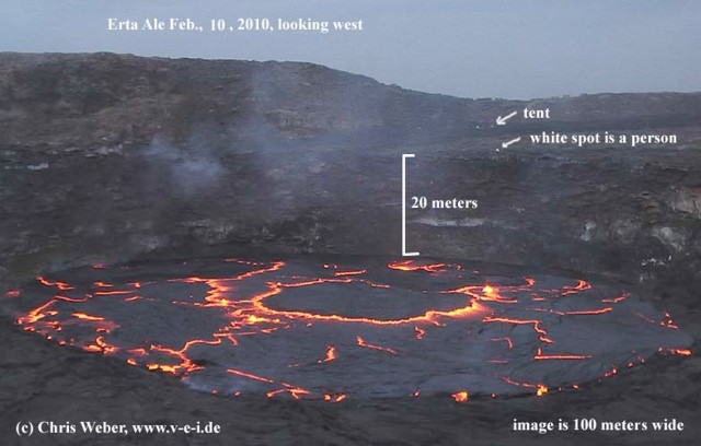 |
Figure 26. Photo looking W towards the southern Erta Ale pit crater taken 10 February 2010. Courtesy of C. Weber. |
 |
Figure 27. Fountaining of the Erte Ale lava lake in the southern pit crater on 9 February 2010. Courtesy of C. Weber. |
Geological Summary. The Erta Ale basaltic shield volcano in Ethiopia has a 50-km-wide edifice that rises more than 600 m from below sea level in the Danakil depression. The volcano includes a 0.7 x 1.6 km summit crater hosting steep-sided pit craters. Another larger 1.8 x 3.1 km wide depression elongated parallel to the trend of the Erta Ale range is located SE of the summit and is bounded by curvilinear fault scarps on the SE side. Basaltic lava flows from these fissures have poured into the caldera and locally overflowed its rim. The summit caldera usually also holds at least one long-term lava lake that has been active since at least 1967, and possibly since 1906. Recent fissure eruptions have occurred on the N flank.
Information Contacts: Christoph Weber, Volcano Expeditions International (VEI), Muehlweg 11, 74199 Untergruppenbach, Germany (URL: http://www.v-e-i.de/).