Report on Piton de la Fournaise (France) — March 2010

Bulletin of the Global Volcanism Network, vol. 35, no. 3 (March 2010)
Managing Editor: Richard Wunderman.
Piton de la Fournaise (France) Seismicity and eruptions January 2009 and November 2009-January 2010
Please cite this report as:
Global Volcanism Program, 2010. Report on Piton de la Fournaise (France) (Wunderman, R., ed.). Bulletin of the Global Volcanism Network, 35:3. Smithsonian Institution. https://doi.org/10.5479/si.GVP.BGVN201003-233020
Piton de la Fournaise
France
21.244°S, 55.708°E; summit elev. 2632 m
All times are local (unless otherwise noted)
Eruptions from Piton de la Fournaise resumed in September 2008 after more than 16 months of quiet (BGVN 34:02). Eruptive episodes inside Dolomeiu crater, as reported by the Observatoire Volcanologique du Piton de la Fournaise (OVPDLF), took during 21 September-2 October and on 28 November 2008, with a third that began on 15 December and continued into January 2009. This report presents observations from January 2009 through January 2010.
Eruptions during 21 September 2008-4 February 2009. Eruptive phases in September, November, and December 2008 were previously described (BGVN 34:02). OVPDLF reported that the episode that began on 14 December 2008 ended on 4 February 2009. During that eruption two vents were active; lava flowed to the bottom of Dolomieu crater through lava tubes and caused the crust over the pooled area to rise. Some incandescence was noted at night and at dawn. Eruption tremor was irregular until 1 January, when it suddenly stopped. Tremor gradually rose over the next few days, but to a relatively low level, where it remained steady until slowly dropping again in early February (figure 79). Lava flows from this eruption covered an area of approximately 420 x 220 m, with a thickness of 75 m (figure 80).
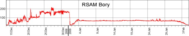 |
Figure 79. Tremor at Piton de la Fournaise, 14 December 2008-5 February 2009. Courtesy of OVPDLF. |
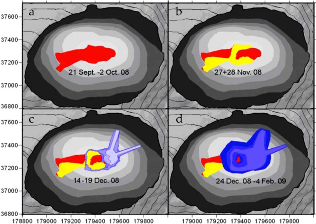 |
Figure 80. Cumulative lava flows in Dolomieu crater at Piton de la Fournaise during the September 2008-February 2009 eruption. Flows covered 420 x 220 m to a depth of 75 m. Courtesy of OVPDLF. |
Activity during October 2009-January 2010. The OVPDLF reported three eruptions from the summit region at the Dolomieu crater's W wall adjacent to Bory crater between November 2009 and January 2010. The flows traveled to the E down the steep cliff toward the crater floor. These eruptions began on 5 November 2009, lasting about two days; on 14 December 2009, lasting 6 hours; and on 2 January 2010, lasting 10 days.
During 5-13 October 2009, OVPDLF reported increased seismicity (figure 81). Seismicity from 14 to 17 October indicated deformation on the N side of, and rockfalls within, the Dolomieu crater. On 18 October another seismic crisis was noted along with deformation on the N and S sides of the Dolomieu crater. Aerial observations on 19 October revealed a small new fumarole in the crater. Unspecified changes in the chemical composition of the gases were also noted. On 20 October rockfalls occured in greater number and longer duration than in previous days.
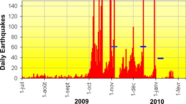 |
Figure 81. A graph showing the number of volcano-tectonic earthquakes/day registered between 1 July 2009 and 26 January 2010 at Piton de la Fournaise. Horizontal bars indicate eruptions. Courtesy OVPDLF. |
On 4 November 2009 a magnitude 3 earthquake at 0604 was felt by some residents of the southern part of the island. Such a magnitude is uncommon at this volcano. Seismologists at the Observatory located the earthquake at 750 m below sea level, under the southwestern edge of the Dolomieu crater. Later that day, 167 earthquakes of lesser magnitude followed. The focal depths rose to ~ 1 km above sea level with epicenters below the summit.
OVPDLF reported that 30 minutes after an intense seismic event on 5 November, a tremor signal characteristic of the beginning of an eruption occurred, and a vent opened inside the southern part of the Dolomieu crater. Within another 30 minutes, a fissure on the upper SE flank propagated E, and a second fissure opened on the E flank.
Lava fountains ~ 20 m high and flows were emitted from both fissures. The glowing lava was visible from the edge of the Enclos Fouqué and from the road in the Grand Brulé. Beginning around 1500, there was a gradual decrease in the intensity of the eruption. At 0645 on 6 November, a reconnaissance was conducted by a helicopter supplied by the National Gendarmerie, which confirmed that two fissures were open in the S side, S and E of the Dolomieu summit crater. Each emitted a lava flow descending to ~ 1,970 m elevation. As of 0730 that day, the lava ceased flowing, with a gradual decrease in the intensity of the eruption tremor.
At 1730 on 14 December a seismic event preceded a rise in summit deformation (8 cm horizontal). Eruptive tremor began at 1830, and an eruption began at 1845. A system of sub-parallel fissures along the summit of Dolomieu crater fed lava flows on the S slope of the volcano, inside the Enclos Fouqué. A second fissure system opened on the E flank of the Dolomieu summit crater at 2025, and lava flows advanced down the eastern slope. This eruption ended at 0040 after a gradual decrease in magma supply. On 15 December, a visible degassing in the S and SE fissures was associated with low-intensity eruptive tremor. All of the lava flows were confined to high portions of the S and SE slopes.
Fissure-fed fountaining sent lava flows down the S flank on 14 December 2009. Another seismic event on 29 December was characterized by numerous earthquakes up to M 3 in the area W and NW of Dolomieu crater at depths of 1.1-2.2 km below the summit. Deformation was also detected. OVPDLF reported decreased seismicity and fewer landslides within Dolomieu crater on 30 and 31 December.
On 2 January 2010 a fissure eruption near the top of the W crater rim (figure 82) was preceded by a seismic event and another 3 cm of horizontal deformation. Lava fountains rose a few tens of meters high and sent lava flows into Dolomieu crater, and ash and gas plumes rose above Piton de la Fournaise. Large landslides also occurred in Bory crater (W). During 2-3 January, seismicity and the number of landslides decreased. A series of ash plumes was noted through 12 January.
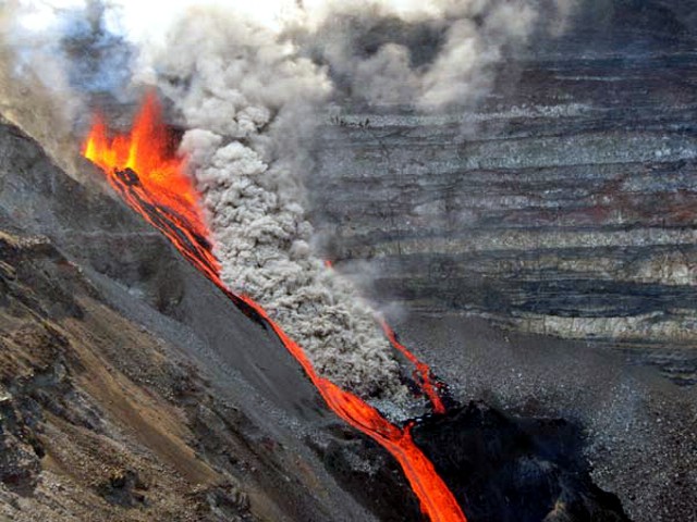 |
Figure 82. Dolomieu crater on 2 January from its W rim showing lava flows and fountains. The dense gray plume was attributed to collapse along the steep crater wall. Courtesy of OVPDLF. |
As of 4 January, the lava flows covered about 80% of the crater floor. Lava fountaining was still visible during 5-7 January and continued to erupt from a vent along a fissure high on the SW Dolomieu crater wall. The vent produced lava fountains and flows that pooled in the bottom of the crater. On 7 January the vent closed, but the previously erupted lava continued to flow for the next few days (figure 83). Seismicity decreased on 12 January and only minor gas emissions persisted. Figure 82 shows the lava flow along the axis where extensive glowing flows were visible. Some flows around this time were fed by lava tubes.
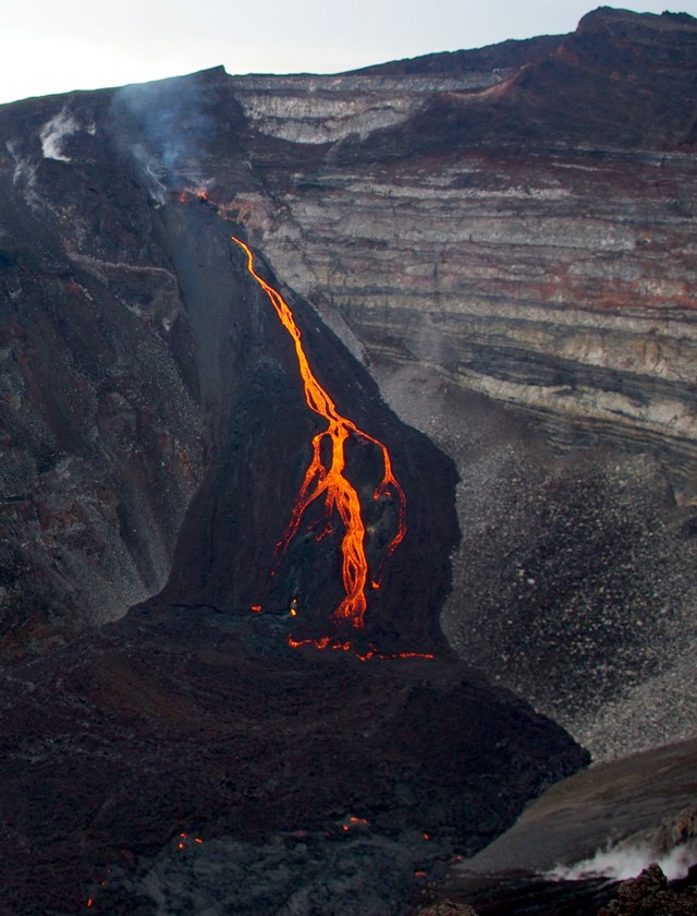 |
Figure 83. A photo taken on the morning of 7 January 2010 of the lava vent flows from the W wall adjacent to Bory crater at Piton de la Fournaise. Courtesy of Undervol, OVPDLF. |
Geological Summary. Piton de la Fournaise is a massive basaltic shield volcano on the French island of Réunion in the western Indian Ocean. Much of its more than 530,000-year history overlapped with eruptions of the deeply dissected Piton des Neiges shield volcano to the NW. Three scarps formed at about 250,000, 65,000, and less than 5,000 years ago by progressive eastward slumping, leaving caldera-sized embayments open to the E and SE. Numerous pyroclastic cones are present on the floor of the scarps and their outer flanks. Most recorded eruptions have originated from the summit and flanks of Dolomieu, a 400-m-high lava shield that has grown within the youngest scarp, which is about 9 km wide and about 13 km from the western wall to the ocean on the E side. More than 150 eruptions, most of which have produced fluid basaltic lava flows, have occurred since the 17th century. Only six eruptions, in 1708, 1774, 1776, 1800, 1977, and 1986, have originated from fissures outside the scarps.
Information Contacts: Laurent Michon and Patrick Bachélery, Laboratoire GéoSciences Réunion, Institut de Physique du Globe de Paris, Université de La Réunion, CNRS, UMR 7154-Géologie des Systèmes Volcaniques, La Réunion, France; Guillaume Levieux, Thomas Staudacher, and Valérie Ferrazzini, Observatoire Volcanologique du Piton de la Fournaise (OVPDLF), Institut de Physique du Globe de Paris, 14 route nationale 3, 27ème km, 97418 La Plaine des Cafres, La Réunion, France (URL: http://www.ipgp.fr/fr/ovpf/actualites-ovpf/).