Report on Egon (Indonesia) — May 2010
Bulletin of the Global Volcanism Network, vol. 35, no. 5 (May 2010)
Managing Editor: Richard Wunderman.
Egon (Indonesia) Volcanic earthquake swarms in late March and early April 2010
Please cite this report as:
Global Volcanism Program, 2010. Report on Egon (Indonesia) (Wunderman, R., ed.). Bulletin of the Global Volcanism Network, 35:5. Smithsonian Institution. https://doi.org/10.5479/si.GVP.BGVN201005-264160
Egon
Indonesia
8.676°S, 122.455°E; summit elev. 1661 m
All times are local (unless otherwise noted)
Following a phreatic eruption on 15 April 2008, Egon was relatively quiet for a year, prompting the Center of Volcanology and Geological Hazard Mitigation (CVGHM) to lower the Alert Level from 2 to 1 on 16 July 2009 (BGVN 34:10). This report notes seismicity and steaming between July 2009 and June 2010.
Egon (figure 1) apparently remained quiet until late March 2010, with an average of one or two daily volcanic earthquakes during January-March. Instruments then recorded a volcanic swarm, with as many as 122 events (amplitudes up to 12 mm, durations up to 45 seconds) during the last few days of March. A volcanic swarm also occurred during the week 31 March-6 April, with 26 events (amplitudes up to 4 mm, durations up to 72 seconds). Since 6 April 2010, small steam plumes rose 10 m above the crater and drifted W.
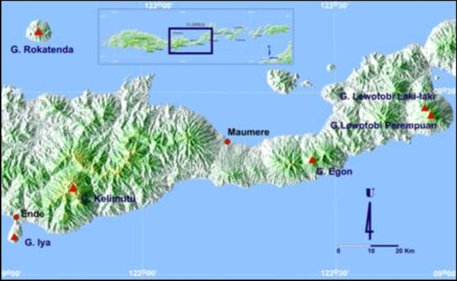 |
Figure 1. A shaded-relief map showing the location of Egon on central Flores Island (upper box) and a more detailed view of the elongate island and some active volcanoes (solid trianges). Courtesy of CVGHM. |
Egon is monitored from the village of Nangatobong, near the island's N coast ~ 6 km NNW of the summit.During the last year and as recent as mid-2010, MODVOLC thermal alerts had been absent.
Geological Summary. Gunung Egon, also known as Namang, sits within the narrow section of eastern Flores Island. The barren, sparsely vegetated summit region has a 350-m-wide, 200-m-deep crater that sometimes contains a lake. Other small crater lakes occur on the flanks. A lava dome forms the southern summit. Solfataric activity occurs on the crater wall and rim and on the upper S flank. Reports of eruptive activity prior to explosive eruptions beginning in 2004 are unconfirmed. Emissions were often observed above the summit during 1888-1892. Strong emissions in 1907 reported by Sapper (1917) was considered by the Catalog of Active Volcanoes of the World (Neumann van Padang, 1951) to be an historical eruption, but Kemmerling (1929) noted that this was likely confused with an eruption on the same date and time from Lewotobi Lakilaki.
Information Contacts: Center of Volcanology and Geological Hazard Mitigation (CVGHM), Saut Simatupang, 57, Bandung 40122, Indonesia (URL: http://vsi.esdm.go.id/); Hawai'i Institute of Geophysics and Planetology (HIGP) Thermal Alerts System, School of Ocean and Earth Science and Technology (SOEST), Univ. of Hawai'i, 2525 Correa Road, Honolulu, HI 96822, USA (URL: http://modis.higp.hawaii.edu/).