Report on Ibu (Indonesia) — May 2010

Bulletin of the Global Volcanism Network, vol. 35, no. 5 (May 2010)
Managing Editor: Richard Wunderman.
Ibu (Indonesia) Dome growth and small explosions continue in 2010
Please cite this report as:
Global Volcanism Program, 2010. Report on Ibu (Indonesia) (Wunderman, R., ed.). Bulletin of the Global Volcanism Network, 35:5. Smithsonian Institution. https://doi.org/10.5479/si.GVP.BGVN201005-268030
Ibu
Indonesia
1.488°N, 127.63°E; summit elev. 1325 m
All times are local (unless otherwise noted)
Activity at Ibu (figure 3) has been frequent since December 1998; the current eruption began in April 2008. Thermal alerts (MODIS/MODVOLC) continued into June 2009, and incandescent ejections were seen in early August (BGVN 34:10).
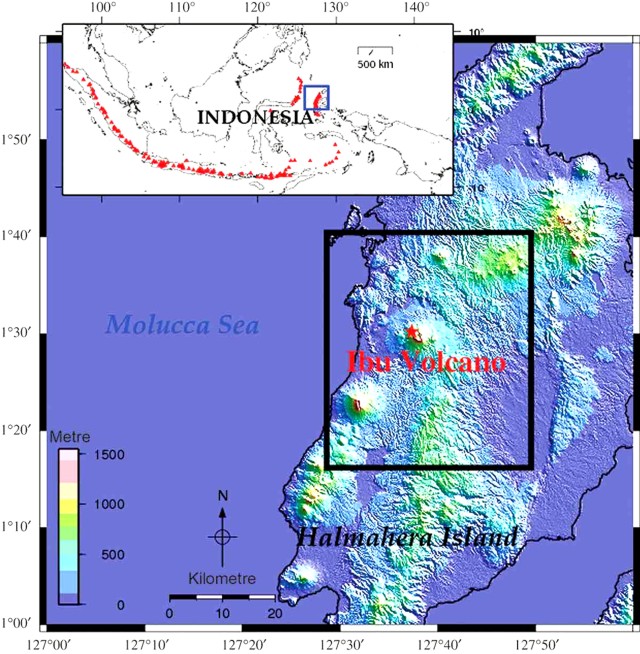 |
Figure 3. Location map of Ibu volcano on Halmahera Island. Insert map shows the locations of other active Indonesian volcanoes with triangles. Courtesy of Agustan and others (2010). |
Between July 2009 and June 2010, thermal alerts at Ibu were detected by MODVOLC on an average of about five or more days every month (normally one pixel per pass?at least one alert each 55 days during the 1-year period), about the same frequency as those measured during the first half of 2009 and far more frequent than that for the 4-year period October 2004-October 2008 (BGVN 33:09). Ground observations reported below in August-September 2009 and January 2010 confirm continued doem growth.
The Center of Volcanology and Geological Hazard Mitigation (CVGHM) reported that white and gray plumes rose 300-400 m above the crater rim during 15 July-4 August 2009 and that earthquakes became more frequent during 27 July-4 August 2009. Lava flows were seen on 2 August. Later that day, a thunderous sound was followed by incandescence at the summit. On 3 August, incandescent material was ejected about 20 m above the crater. The lava dome had reached a height sufficient to be seen from Duono Village, about 5 km NW.
Martin Rietze and Alain de Toffoli took some photographs of Ibu during a 31 August-7 September 2009 visit (figures 4-7), posted on the website of Th. Boeckel. The travelers noted that during the last 10 years the crater has been filled with a lava dome. The volcano has several vents that discharge ash and gas, along with Strombolian ejections. Only two vents were active during the visit.
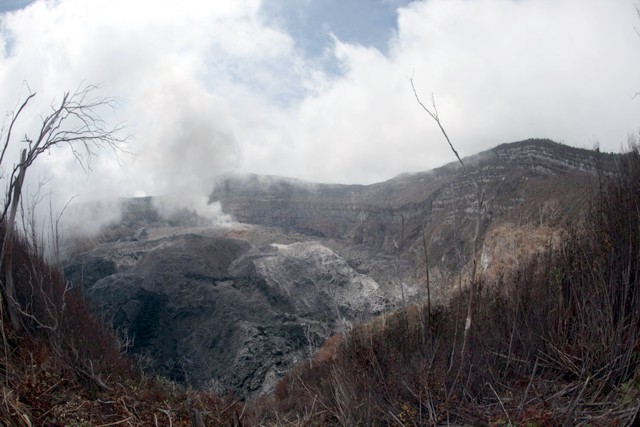 |
Figure 4. Photo of the edge of the Ibu crater, taken during 25 August-8 September 2009. The vegetation near the rim was partially charred, and lava from the dome caused small bush fires. Photo taken from the W rim looking toward the E rim. Courtesy of Alain de Toffoli and M. Rietze. |
 |
Figure 5. Gas and ash emissions from the growing dome at Ibu, taken during 25 August-8 September 2009. Photo taken from the W rim looking E. Courtesy of Alain de Toffoli and M. Rietze. |
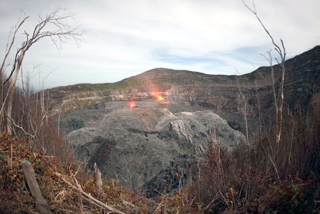 |
Figure 6. Two active vents in Ibu's crater, taken during 25 August-8 September 2009. Photo taken from the W rim looking E. Courtesy of Alain de Toffoli and M. Rietze. |
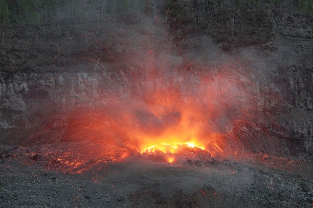 |
Figure 7. Dome growth in Ibu's crater with Strombolian ejections, taken during 25 August-8 September 2009. Photo taken from the W rim looking E. Courtesy of Alain de Toffoli and M. Rietze. |
Arnold Binas posted some photos that demonstrated rapid dome growth (figure 8). Before 1998, the crater was vegetated down to the bottom. The dome was distinctly lower in 2007 (BGVN 34:05). Binas commented that "After a period of no steam emissions at all, [the dome vent] would start steaming slightly to announce it's next eruption. After being done emitting rocks and ash, it would steam vigorously for a while before quieting down again." Binas was also told that material had started to go through a breach in the N side of the crater.
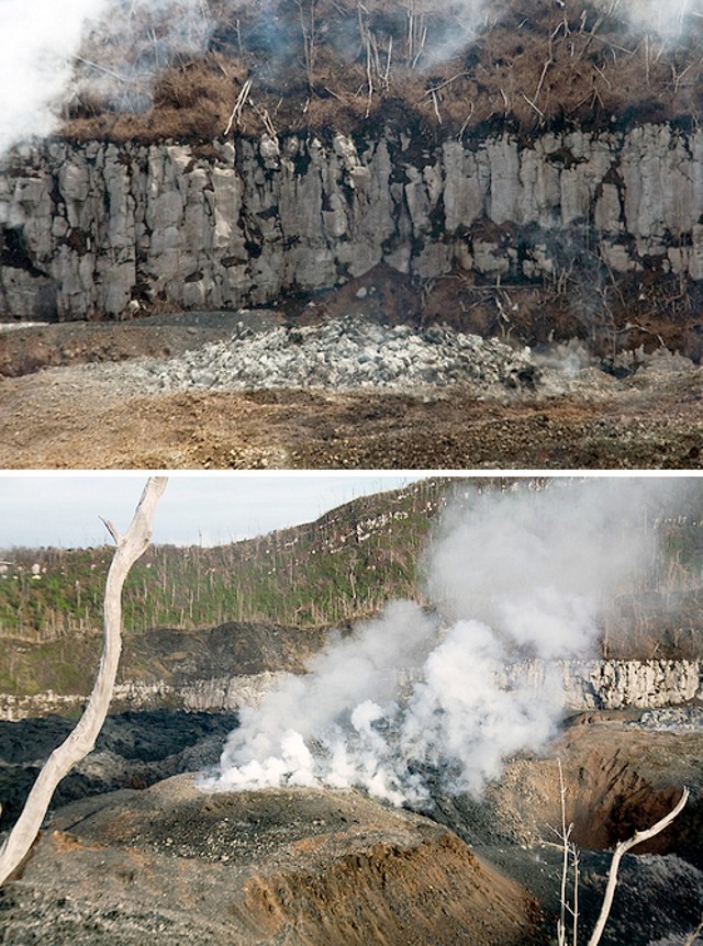 |
Figure 8. Growth in a single day at Ibu's dome from one of the two vents erupting around 21 January 2010. The top photo was taken during a moment of quiet, and is the older image. Both photos taken from the W rim looking E. Courtesy of Arnold Binas. |
A recent article by Agustan and others (2010) used radar to measure ground deformation related to volcanic activity on Ibu. Specifically, they used longer wavelength (L-band) differential interferometry to identify an inflation-deflation region, especially in the crater area before the March-April 2008 eruption (BGVN 33:09).
Reference. Agustan, Kimata, F., Abidin, H.Z., and Pamitro, Y.E., 2010, Measuring ground deformation of the tropical volcano, Ibu, using ALOS-PALSAR data, Remote Sensing Letters, v. 1, issue 1, p. 37-44, DOI: 1080/01431160903246717.
Geological Summary. The truncated summit of Gunung Ibu stratovolcano along the NW coast of Halmahera Island has large nested summit craters. The inner crater, 1 km wide and 400 m deep, has contained several small crater lakes. The 1.2-km-wide outer crater is breached on the N, creating a steep-walled valley. A large cone grew ENE of the summit, and a smaller one to the WSW has fed a lava flow down the W flank. A group of maars is located below the N and W flanks. The first observed and recorded eruption was a small explosion from the summit crater in 1911. Eruptive activity began again in December 1998, producing a lava dome that eventually covered much of the floor of the inner summit crater along with ongoing explosive ash emissions.
Information Contacts: Center of Volcanology and Geological Hazard Mitigation (CVGHM), Saut Simatupang, 57, Bandung 40122, Indonesia (URL: http://vsi.esdm.go.id/); Hawai'i Institute of Geophysics and Planetology (HIGP) Thermal Alerts System, School of Ocean and Earth Science and Technology (SOEST), Univ. of Hawai'i, 2525 Correa Road, Honolulu, HI 96822, USA (URL: http://modis.higp.hawaii.edu/); Martin Rietze (URL: http://www.mrietze.com/info.htm); Arnold Binas, Toronto, Canada (URL: http://www.flickr.com/photos/hshdude/).