Report on South Sarigan Seamount (United States) — May 2010
Bulletin of the Global Volcanism Network, vol. 35, no. 5 (May 2010)
Managing Editor: Richard Wunderman.
South Sarigan Seamount (United States) Sudden, short-lived, explosive eruption from submarine vent
Please cite this report as:
Global Volcanism Program, 2010. Report on South Sarigan Seamount (United States) (Wunderman, R., ed.). Bulletin of the Global Volcanism Network, 35:5. Smithsonian Institution. https://doi.org/10.5479/si.GVP.BGVN201005-284193
South Sarigan Seamount
United States
16.58°N, 145.78°E; summit elev. -184 m
All times are local (unless otherwise noted)
According to a weekly USGS/CNMI Emergency Management Office (EMO) update on 4 June 2010, an explosive eruption from a submarine vent S of Sarigan Island occurred during 28-29 May 2010. The most energetic phase of the eruption, at 2147 on 29 May, lasted about 10 minutes based on seismic records from nearby Sarigan and Anatahan islands. The eruption sent an ash and gas cloud perhaps as high as 12.2 km altitude. Precursors included two moderate earthquakes and many smaller shocks; an earthquake of ~ M 4.8 accompanied the eruption. The plume drifted S, eventually passing over Guam (350 km SSW), but no fallout was reported there or on Saipan (165 km S).
Evidence of submarine volcanic activity was first observed late on 28 May during aerial observations by Juan Camacho, an EMO technician, who noted an elongate patch of discolored ocean water and possible light-colored floating debris about 8 km S of Sarigan Island. Alaska Volcano Observatory seismologists noted tremor on nearby seismic stations about the same time. Satellite image analysis by the National Weather Service in Guam indicated that the area of disturbance had grown significantly in size prior to the 29 May explosion. Within hours after the eruption, seismic activity began to decline, and after 31 May only a few scattered events were recorded.
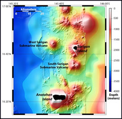
The vent's exact location and depth remained uncertain. According to the USGS, the most likely source is the summit area of the South Sarigan seamount ~ 11 km S of Sarigan Island (figure 1). The summit of the conical structure lies at depths less than ~ 500 m below the surface.
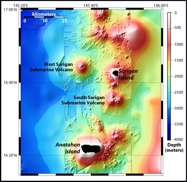 |
Figure 1. Location map showing the volcanic islands of Sarigan and Anatahan, as well as the South and West Sarigan volcanic seamounts. Modified from Embley and Chadwick (2003). |
A U.S. Fish and Wildlife Service research crew camped on Sarigan Island reported many felt earthquakes prior to the eruption. An explosion that sounded like thunder accompanied the event. They also heard increasing ocean wave activity during the night. Subsequently, a minor ashfall occurred.
The NOAA West Coast and Alaska Tsunami Warning Center reported that a 5-cm-high tsunami related to this event may have been recorded on a tide gauge in Saipan. According to a news article in the Saipan Tribune, the U.S. Fish and Wildlife evacuated 16 people, mostly scientists, from nearby islands, including eight people from Sarigan.
The USGS reported no evidence of volcanism after the 29 May eruption. Seismicity recorded by the nearest seismometer, on Sarigan Island, had returned to background levels. Nothing unusual was observed in satellite data.
Reference. Embley, B., and Chadwick, B., 2003, MR1 sonar provides new view of sea floor around Mariana Islands: NOAA Ocean Explorer, Submarine Ring of Fire 2003, 17 February 2003 (http://oceanexplorer.noaa.gov/explorations/03fire/logs/feb17/feb17.html).
Geological Summary. South Sarigan seamount, rising to within about 184 m of the ocean surface 12 km S of Sarigan Island, was the site of a short explosive submarine eruption in May 2010 that produced a plume of ash and steam to 12 km altitude. Sidescan sonar imagery taken in 2003 shows an irregular summit with multiple peaks, including a possibly young cone at about 350 m depth, and flank morphology suggests it is a frequently active volcano.
Information Contacts: Emergency Management Office of the Commonwealth of the Northern Mariana Islands (EMO-CNMI) and USGS Hawaii Volcano Observatory, PO Box 100007, Saipan, MP 96950, USA (URL: http://www.cnmihsem.gov.mp/ and https://volcanoes.usgs.gov/nmi/activity/); NOAA Ocean Explorer, National Oceanic and Atmospheric Administration, U.S. Department of Commerce (URL: http://oceanexplorer.noaa.gov/explorations/03fire/logs/feb17/feb17.html).