Report on Yasur (Vanuatu) — June 2010

Bulletin of the Global Volcanism Network, vol. 35, no. 6 (June 2010)
Managing Editor: Richard Wunderman.
Yasur (Vanuatu) Increased activity during the first half of 2010; continued eruptions since 2004
Please cite this report as:
Global Volcanism Program, 2010. Report on Yasur (Vanuatu) (Wunderman, R., ed.). Bulletin of the Global Volcanism Network, 35:6. Smithsonian Institution. https://doi.org/10.5479/si.GVP.BGVN201006-257100
Yasur
Vanuatu
19.532°S, 169.447°E; summit elev. 361 m
All times are local (unless otherwise noted)
Yasur has a record of at least several hundred years of near-constant eruptions from several vents. A period of increased activity in June 2004 (BGVN 29:07) included Strombolian behavior, low intensity explosions with lava bombs, dense ash plumes, and elevated SO2 levels. Located on Tanna Island (figure 39), this volcano is a major tourist attraction due to an access road to an overlook point (figure 40). Regular activity has continued since mid-2004 through mid-2010. MODVOLC alerts based on infrared imagery detected by satellite have occurred in every month since the previous report in 2004.
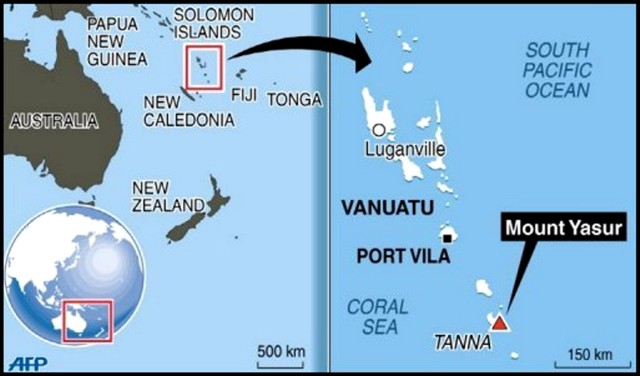 |
Figure 39. Maps indicating the locations of the nation of Vanuatu, Tanna Island, and Yasur volcano. Courtesy of Agence France-Presse. |
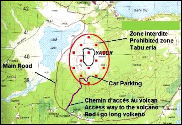 |
Figure 40. Web map of Yasur volcano in July 2010 showing the prohibited zone, the parking lot and other features. Courtesy of Vanuatu Geohazards Observatory (VGO). |
Although scientific reports have not been available, visitors to the volcano often post photographs on internet sites. For example, a quick review of Flickr images showed Strombolian ejections from multiple vents, and small ash explosions, that were taken in November 2005, May, September, and December 2006, January and September 2007, May, June, August, and September 2008. Similar activity was documented during March, May, June, and July 2009. An aerial photograph taken on 12 June 2009 showed a mostly white plume rising just above the summit (figure 41).
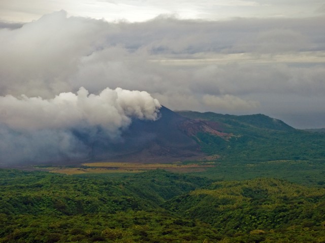 |
Figure 41. Photograph showing a plume from Yasur being blown downwind on 12 June 2009. The plume appears mostly white, with some possible ash. The day is overcast with darker rain clouds overhead. Courtesy of PhillipC (Creative Commons license). |
During January 2010 activity began to increase. A report from the Wellington Volcanic Ash Advisory Centre (VAAC) noted that on 11 January 2009 a plume had risen to an altitude of 4 km and drifted SE. Volcanic ash was not identifiable from satellite data. On 21 January, OMI satellite images indicated a significant increase in sulfur dioxide gas emissions (at least 2,000 metric tons/day).
According to the Vanuatu Geohazards Observatory (VGO), during the first week of March 2010 bombs were ejected. Observations on 8 March and analyses of seismic data both indicated increased emissions at all three vents. According to VGO, Yasur maintained its high activity during April and most of May 2010, with strong degassing and ash emissions from all three active vents. Ash fell on most parts of the island. Fresh volcanic bombs fell around the crater rim, and a few reached the ash plain and the parking area. A photo showed an elongate, ~ 1.5-m-long bomb that fell on 23 April lying on the ash plain. Explosions could be heard and viewed from nearby villages. OMI satellite data did not disclose elevated SO2 levels on 9 May 2010.
Activity increased again in late May; according to VGO, activity included moderate-to-large eruptions with strong explosions, ejected bombs that fell on the visitor viewing area, and significant ashfall in nearby villages. Visitors were not allowed to approach within about 500 m of the volcano. According to the Wellington VAAC, ash plumes rose to an altitude of 1.8 km every day between 29 May and 10 June 2010. Volcanic ash was not identifiable from satellite data except for 30 and 31 May. According to a news article, the plume on 1 June spread over 340 km2, canceling or delaying some flights in and out of New Caledonia (~ 430 km WSW).
In early June, activity decreased. Explosions became less frequent, but Strombolian activity continued with occasional ejections of lava bombs.
Heightened activity recurred in early July 2010. The VGO noted strong degassing and ash emissions from all the three active vents. Ashfall primarily occurred over the western portion of the island and fresh volcanic bombs fell around the crater rim. Some explosions could be heard and viewed from nearby villages. Visitor photos showed continuing Strombolian activity at the vents on 26 July and 7 August 2010.
Geological Summary. Yasur has exhibited essentially continuous Strombolian and Vulcanian activity at least since Captain Cook observed ash eruptions in 1774. This style of activity may have continued for the past 800 years. Located at the SE tip of Tanna Island in Vanuatu, this pyroclastic cone has a nearly circular, 400-m-wide summit crater. The active cone is largely contained within the small Yenkahe caldera, and is the youngest of a group of Holocene volcanic centers constructed over the down-dropped NE flank of the Pleistocene Tukosmeru volcano. The Yenkahe horst is located within the Siwi ring fracture, a 4-km-wide open feature associated with eruption of the andesitic Siwi pyroclastic sequence. Active tectonism along the Yenkahe horst accompanying eruptions has raised Port Resolution harbor more than 20 m during the past century.
Information Contacts: Vanuatu Geohazards Observatory, Geo-Hazard Section, Department of Geology, Mines and Water Resources, PMB 01, Port Vila, Vanuatu (URL: http://www.vmgd.gov.vu/vmgd/); Wellington Volcanic Ash Advisory Centre (VAAC), Meteorological Service of New Zealand Ltd (MetService), PO Box 722, Wellington, New Zealand (URL: http://www.metservice.com/vaac/, http://vaac.metservice.com/); Hawai'i Institute of Geophysics and Planetology (HIGP) Thermal Alerts System, School of Ocean and Earth Science and Technology (SOEST), Univ. of Hawai'i, 2525 Correa Road, Honolulu, HI 96822, USA (URL: http://modis.higp.hawaii.edu/); Flickr.com (Photographer: PhillipC, http://www.flickr.com/photos/flissphil/); Agence France-Presse (URL: http://www.afp.com/); Radio New Zealand International (URL: http://www.rnzi.com/).