Report on NW Rota-1 (United States) — July 2010
Bulletin of the Global Volcanism Network, vol. 35, no. 7 (July 2010)
Managing Editor: Richard Wunderman.
NW Rota-1 (United States) Continued eruptive activity during March 2010 visit
Please cite this report as:
Global Volcanism Program, 2010. Report on NW Rota-1 (United States) (Wunderman, R., ed.). Bulletin of the Global Volcanism Network, 35:7. Smithsonian Institution. https://doi.org/10.5479/si.GVP.BGVN201007-284211
NW Rota-1
United States
14.601°N, 144.775°E; summit elev. -517 m
All times are local (unless otherwise noted)
William Chadwick of the U.S. National Oceanographic and Atmospheric Agency (NOAA) sent us a draft abstract of a research paper (Chadwick and others, 2010a) concerning recent observations on the volcano named NW Rota-1 in the Mariana Islands (figure 7). The abstract was submitted to the American Geophysical Union (AGU) in 2010 for presentation at a future meeting. Chadwick noted that NW Rota-1 appears to have been continuously active since first visited by NOAA scientists in 2003 (BGVN 29:03), and definitely between February 2008 and March 2010 while it was monitored with a continuously recording moored hydrophone (BGVN 33:02 and 34:06). A detailed report of the 16-30 March 2010 expedition appears at the VENTS Program website (Chadwick and others, 2010b).
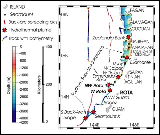 |
Figure 7. Broad-scale map showing part of the Northern Mariana Islands and vicinity (an area roughly midway between the main island of New Guinea on the S, and Tokyo, Japan on the N). The islands shown include Guam, Rota, Saipan, and others. The map emphasizes the location of the active submarine volcano NW Rota-1 and the currently quiet submarine caldera West Rota. After Embley and others, 2004; courtesy of the American Geophysical Union. |
Chadwick and others (2010a and 2010b) described the March 2010 expedition aboard the research vessel RV Kilo Moana and deploying the remotely operated vehicle (ROV) Jason. The expedition found the submarine volcano was still erupting more or less continuously, as has been observed since 2004. In addition, the expedition discovered that a major zone of submarine mass wasting (a "seaslide" ? hereafter, slide, figure 8). The slide had occurred since the last visit in April 2009 and the available on-site hydrophone record suggested it could have taken place around 14 August 2009 amid a 3-day eruptive episode. The ROV Jason dive observations revealed the responses of the volcano's magmatic and hydrothermal systems to such a collapse, as well as how the resident chemosynthetic biological community has responded to the event.
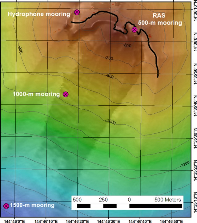 |
Figure 8. At NW Rota-1, the approximate trace of the headscarp (bold line) for a large submarine slide discovered when visited in March 2010. Only one of the four hydrophones were found, the one located farthest N. The others were presumably destroyed during the slide, which sent material to the SW from the headscarp area. Note the reentrant near the center of the mapped headscarp. This zone is where the high-temperature vents were found (see next figure). "RAS 500-m mooring" refers to a remote access sampler that took samples at timed intervals at a hydrothermal vent. That device was lost due to the slide. Taken from Chadwick and others (2010b). |
The morphological changes from the slide were quantified by comparing multibeam bathymetric surveys between 2009 and 2010. Compared to the former summit ridge, the slide's headscarp in 2010 stood ~ 100 m farther N and in this upslope region depths changed by up to 90 m. The slide excavated material from the upper S slope to a distance of 3.5 km downslope, and deposited material 2-8 km from the summit down to at least a depth of 2,800 m on the flank.
The area and volume of slide deposits (positive depth changes) were 7.1 x 10⁶ m2 (~ 7 km2) and 5.3 x 10⁷ m3, respectively, and the maximum thickness was +42 m. The area and volume of material removed by the slide (negative depth changes) were 2.2 x 10⁶ m2 and -4.1 x 10⁷ m3, respectively. The changes in morphology near the summit show that the slide primarily removed loose volcaniclastic deposits that had accumulated near the active eruptive vent, exposing an underlying stock-like core of resistant intrusive rocks and massive lavas at the summit.
In preliminary investigations, scientists found no evidence for a local tsunami generated by the slide. For example, a scan of mid-August tide-gage data on the W side of Guam (Aprons Harbor) did not show compelling evidence for a tsunami.
Jason dives found that most of the hydrothermal vent sites visited in 2009 had been wiped out, but a few survived, and new ones had formed. The lava cone that had grown at Brimstone vent last year was completely gone in March 2010. Brimstone vent was ~ 25 m deeper than last year when its depth was ~ 555 m, but about in the same location. Its hydrothermal was comparatively quiet compared to last year. However, the 2010 expedition found at least four other (deeper) eruptive or hydrothermal vents adjacent to Brimstone in an E-W line (figure 9). The eruptive activity was variable, with individual vents turning on and off daily or even hourly. Some eruptions were documented (eg., figure 10) and vent areas were sampled.
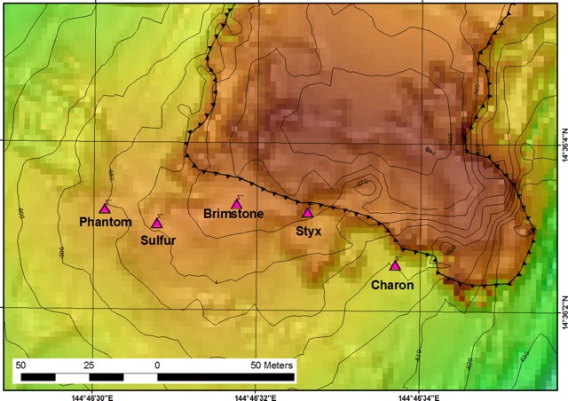 |
Figure 9. High-temperature vents seen in 2010. Bold decorated line indicates the approximate location of the slide's headscarp, along which material to the S was translated to the SW, thus potentially affecting these vents. To facilitate navigation and aid in quantifying changes, the 2009 crew left occasional survey markers on the seafloor in this region. When dived on in 2010, the slide had removed 10 of these markers, venting had damaged or destroyed two markers, and three remained intact. Taken from Chadwick and others (2010b). |
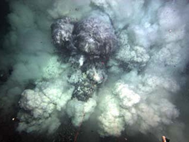 |
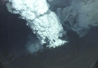
Figure 10. During the 2010 expedition, ROV Jason captured this eruption at Styx vent (depth, ~ 560 m). Original caption was "Large eruption at Styx Vent with tephra, gas bubbles, and extensive plume [27 March 2010 at 0428, on dive J-494]." Logs from around this time described several eruption plumes; observations also included submarine plumes with bifurcating cells. Taken from Chadwick and others (2010b). |
During March 2010, there were at least five vents displaying eruptive or high-temperature behavior (or both, including Phantom, Sulfur, Brimstone, Styx, and Charon) along a 200-m-long line (figure 9). The biological community at NW Rota-1 previously included two species of shrimp in about equal numbers. However, after the slide, the Alvinocaris shrimp species was almost gone, whereas the Opaepele loihi shrimp were present in the thousands.
A hydrophone mooring deployed ~ 150 m W of the summit survived and recorded the sounds of eruptive activity since February 2009. In addition, one monitoring instrument was moved 1 km downslope and buried by the slide, and two others were destroyed. The surviving hydrophone provides critical data on the time of the slide. The loss of the other recorders gave scientists a more limited view of the volcano's behavior, but the scale of the slide was also much larger than they thought possible and is perhaps the largest submarine slide yet monitored at close range.
The report noted "the moored hydrophone that we recovered[, which] had been recording since February 2009, shows that the landslide probably occurred on 14 August 2009, apparently in the middle of an intense eruptive episode that lasted more than 3 full days." The associated acoustical signals were the largest during the two-year period of monitoring. After months of continuous, short duration (~ 1 minute) explosions, the slide seemingly occurred within a 5-6 hour period on 14 August. The signals suggested that an intense, continuous eruption triggered the slide. Inspection also revealed impact to the surviving hydrophone's mooring.
References. Chadwick, Jr., W.W., Dziak, R.P., Embley, R.W., Tunnicliffe, V., Sherrin, J., Cashman, K.V., and Deardorff, N., 2010a, Submarine landslide triggered by eruption recorded by in-situ hydrophone at NW Rota-1 submarine volcano, Mariana Arc: draft abstract submitted to American Geophysical Union.
Chadwick, W., Wehmeyer, B., Heintz, M., and Bobbitt, A., 2010b, NW Rota-1 2010 cruise report: R/V Kilo Moana, cruise KM-1005, March 16-30, 2010, Guam-Guam (JASON Dives J2-486 to J2-495): NOAA Vents Program, 293 p. (URL: http://www.pmel.noaa.gov/vents/marianas/NWRota-2010-CruiseReport.pdf).
Embley, R.W., Baker, E.T., Chadwick, Jr., W.W., Lupton, J.E., Resing, J.A., Massoth, G.J., and Nakamura, K., 2004, Explorations of Mariana Arc volcanoes reveal new hydrothermal systems: EOS-Transactions of the American Geophysical Union, v. 85, no. 4, p. 37 and 40.
Geological Summary. A submarine volcano detected during a 2003 NOAA bathymetric survey of the Mariana Island arc was found to be hydrothermally active and named NW Rota-1. The basaltic to basaltic andesite seamount rises to within 517 m of the ocean surface SW of Esmeralda Bank, 64 km NW of Rota Island and ~100 km N of Guam. When Northwest Rota-1 was revisited in 2004, a minor submarine eruption from a vent named Brimstone Pit on the upper south flank about 40 m below the summit intermittently ejected a plume several hundred meters high containing ash, rock particles, and molten sulfur droplets that adhered to the surface of the remotely operated submersible vehicle. The active vent was funnel-shaped, about 20 m wide and 12 m deep. Prominent structural lineaments about a kilometer apart cut across the summit of the edifice and down the NE and SW flanks.
Information Contacts: William W. Chadwick, Oregon State University and NOAA Vents Program, Newport, Oregon; 2115 SE OSU Drive, Newport, OR 97365 USA (URL: http://nwrota2009.blogspot.com/).