Report on Chachadake [Tiatia] (Japan - administered by Russia) — July 2010
Bulletin of the Global Volcanism Network, vol. 35, no. 7 (July 2010)
Managing Editor: Richard Wunderman.
Chachadake [Tiatia] (Japan - administered by Russia) Thermal anomalies detected during February-June 2010
Please cite this report as:
Global Volcanism Program, 2010. Report on Chachadake [Tiatia] (Japan - administered by Russia) (Wunderman, R., ed.). Bulletin of the Global Volcanism Network, 35:7. Smithsonian Institution. https://doi.org/10.5479/si.GVP.BGVN201007-290030
Chachadake [Tiatia]
Japan - administered by Russia
44.353°N, 146.252°E; summit elev. 1822 m
All times are local (unless otherwise noted)
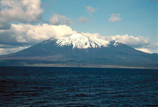
No eruptive or thermal activity is known on Tiatia between 1988 and the beginning of 2010, but thermal anomalies began in February 2010. During its last activity, in 1988, Tiatia displayed steaming in many parts of the crater (SEAN 13:11). The volcano, whose alternate names include Tyatya and Chacha-dake, sits near the NE margin of Kunashir Island (figures 1-3).
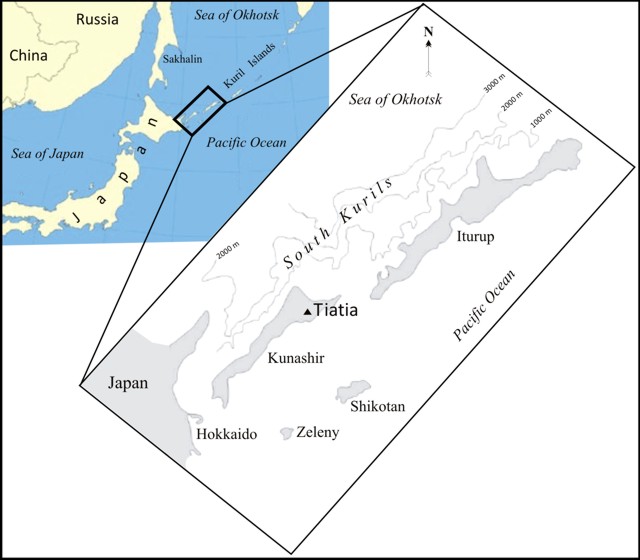 |
Figure 1. A map showing the location of Tiatia volcano very near the southern end of the Kurile island chain. For scale, NE-trending Kunashir Island is 123 km long. Tiatia and the city of Sapporo (on the NW side of Hokkaido Island, Japan) are ~ 600 km apart. |
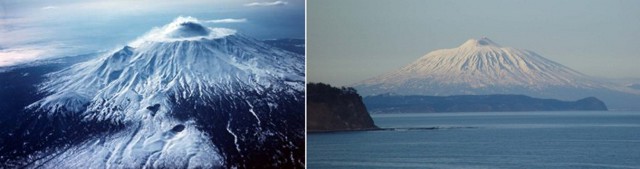 |
Figure 2. Two aerial views of Tiatia disclose its striking morphology. (left) View in 1973 showing the symmetrical caldera rim, which encircles an axially symmetrical inner cone with a broken top; scoria cones lie on the SE slope (mid- to foreground). (right) Viewed from the S in 2008 on a clear day. Courtesy of volcanologist Anatoly Khrenov (1973 photo) and blogger Udachnik (2008 photo). |
 |
Figure 3. An ASTER image of Tiatia taken on 29 June 2006 shows considerable snow surrounding the crater and down the caldera's flanks. Where visible, the slopes generally appear densely vegetated, except for the crater, some upslope areas, and around minor cones on the lower right and upper center. N is towards the top; the summit caldera is ~ 2 km in diameter. Courtesy of Aster Volcano Archive. |
According to the Sakhalin Volcanic Eruption Response Team (SVERT), thermal anomalies were detected during 2010 by satellite on 9 February, 31 May, 10 June, 19 June, and 25 June. Tiatia lacks a local seismic instrument and satellites are the primary tool used for monitoring. The satellites used in detecting these anomalies was not identified. MODVOLC thermal alerts were absent, a circumstance that could be explained by their reasonably high threshold in order to minimize the mis-identification of thermal activity.
Geological Summary. The symmetrical Chachadake, also known as Tiatia, is on the SE side of northern Kunashir Island in the southern Kuriles. The active cone rises above the rim of a filled 2.1 x 2.4 km summit caldera with erosionally furrowed flanks. The central cone, mostly formed by basaltic to basaltic andesite Strombolian eruptions, rises 400 m above the floor of the caldera and contains a 400 x 250 m wide crater with two explosion vents separated by a linear septum. Fresh lava flows cover much of the SW caldera floor and have overflowed the rim, extending to the foot of the older edifice, which formed during the late Pleistocene or early Holocene. A 500-m-wide crater about 2 km down the SE flank from the caldera rim is surrounded by an unvegetated area of volcanic deposits. The first recorded eruption was in 1812, and a major explosive eruption with lava flows in 1973 originated from vents on the central cone.
Information Contacts: Sakhalin Volcanic Eruption Response Team (SVERT), Alexander Rybin, IMGG FEB RAS, Yuzhno-Sakhalinsk (URL: http://www.imgg.ru/); The ASTER Volcano Archive (AVA), NASA Jet Propulsion Lab, California Institute of Technology (URL: http://ava.jpl.nasa.gov/volcano.asp); Hawai'i Institute of Geophysics and Planetology (HIGP) Thermal Alerts System, School of Ocean and Earth Science and Technology (SOEST), Univ. of Hawai'i, 2525 Correa Road, Honolulu, HI 96822, USA (URL: http://modis.higp.hawaii.edu/); Udachnik (URL: http://dirty.ru/comments/245960).