Report on Arenal (Costa Rica) — July 2010

Bulletin of the Global Volcanism Network, vol. 35, no. 7 (July 2010)
Managing Editor: Richard Wunderman.
Arenal (Costa Rica) Ongoing lava flows and pyroclastic flows during August 2008-June 2010
Please cite this report as:
Global Volcanism Program, 2010. Report on Arenal (Costa Rica) (Wunderman, R., ed.). Bulletin of the Global Volcanism Network, 35:7. Smithsonian Institution. https://doi.org/10.5479/si.GVP.BGVN201007-345033
Arenal
Costa Rica
10.463°N, 84.703°W; summit elev. 1670 m
All times are local (unless otherwise noted)
Activity at Arenal during July 2008-14 September 2010 included ongoing eruptions emitting both lava flows and small pyroclastic flows. In the latter part of the reporting interval, scientists noted more rock collapses than eruptions containing pyroclasts.
Vigorous activity through mid-June 2008 consisted of explosive and effusive eruptions and pyroclastic flows down multiple flanks that reached up to 1 km long (BGVN 33:06). The pyroclastic flows left a tongue-like deposit with a central depression along its longitudinal axis. Ongoing eruptions at the active Crater C filled in that depression out to ~ 800 m from the crater rim.
Activity during July-August 2008. The Observatorio Vulcanologico Sismologica de Costa Rica-Universidad Nacional (OVSICORI-UNA) reported that during August 2008, activity originating from Arenal's Crater C consisted of gas emissions, sporadic Strombolian eruptions, and occasional avalanches from lava-flow fronts that traveled down the SW flanks. During July and August 2008 there were fewer explosions than previous months, although one substantial explosion took place on 24 July. These generally calmer conditions had persisted since 18 June 2008 (BGVN 33:06).
OVSICORI-UNA reported that during August 2008, acid rain and small amounts of ejected pyroclastic material affected the NE and SE flanks. Eruptions produced ash plumes that rose to ~ 2.2 km altitude. Small avalanches of volcanic material traveled down several ravines. Crater D experienced only fumarolic activity.
Activity during September 2008. An OVSICORI field report from 16 September 2008 documented morphological changes at Arenal during the previous several months, including burnt vegetation on the E and NE flanks, especially toward the summit (figure 105).
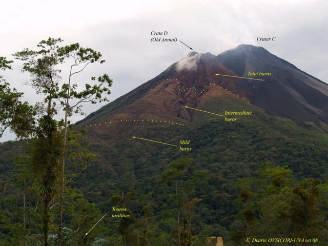 |
Figure 105. Areas of burnt vegetation as seen in September 2008 at Arenal, illustrating severe burns near the summit. A fine layer of dust covering the burnt vegetation that originated from minor pyroclastic flows on the W side. Courtesy E. Duarte, OVSICORI-UNA. |
Most notably on the SW flanks, the paths of pyroclastic flows from June 2008 had become increasingly covered by debris, including lava blocks and material from smaller pyroclastic flows, forming 800-m-long tongues of elevated, leveed deposits (figures 106-107).
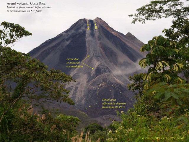 |
Figure 106. September 2008 photo of Arenal's prominent SW flank showing the effects of ongoing incandescent avalanches covering the June 2008 pyroclastic flows. The notch at the summit infilled and abundant material accumulated at 1,200 m elevation, where during 3 months levees grew. This photo shows a variety of features including the notch in the crater rim (A-B), a set of confining levees along the deposits margins, an area with significant new deposition since then (labeled), a mound-like terminal fan that had still accumulated more deposits as late as September 2008, and a distal area of the June 2006 pyroclastic flows. Courtesy of E. Duarte, OVSICORI-UNA. |
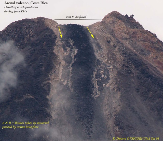 |
Figure 107. September 2008 view of Arenal's notch and upper gully partially filled by recent blocky material. Courtesy of E. Duarte, OVSICORI-UNA. |
A small longitudinal depression (or chute) originally bounded by levees along the June pyroclastic flows had largely been filled by September 2008. Observers noticed these levees in lava flows after 1971 and they have become more common in recent decades.
Material accumulated on either side of the levees, for example, near the lava flow's distal end. There a fan formed, spanning ~ 200 m wide and consisting of pulverized, previously incandescent material. About 800 m below the summit on the SW flank, the levee and gully ended at a barrier that halted movement of eroded material farther downslope. At the summit, the SW edge became blocked with accumulated material, causing some incandescent blocks to roll down the N side.
The SW flank avalanches funneled through the gully. This resulted in particles fractured and ground into finer grain sizes, generating columns of ash. During the visit, the team observed several avalanches containing large blocks that arrived at the lower part of the fan with temperatures between 800 and 1,000°C. The large blocks also seemingly cracked as the result of thermal shock, a process seen to be accelerated during a strong rainstorm.
Activity during January 2009-September 2010. Eruptive activity at Crater C during January 2009 through June 2010 was consistently low but, as before, included gas emissions, sporadic Strombolian eruptions, and occasional avalanches from lava-flow fronts that traveled down the W and SW flanks (also S and SE flanks during February 2010 to May 2010). Acid rain and small amounts of ejected pyroclastic material continued to damage vegetation on the NE and SE flanks (also E flank in January 2010 - September 2010). Eruptions produced ash plumes that rose to an altitude of about 2.2 km. Small avalanches of volcanic material traveled down several ravines, occasionally igniting vegetation. Lava flowed down the S and SW flank in mid-January 2010 through at least early June 2010, causing small avalanches and igniting vegetation. Crater D continued to show only fumarolic activity.
A 17 April 2009 news article reported that Arenal monitoring had increased on 1 April 2009 after the National Commission of Emergencies (CNE) and the National Seismic Network (RSN) detected increased seismicity there.
According to a 15 June 2009 news report, scientists from the University of Costa Rica (UCR) and the Instituto Costarricense de Electricidad (ICE) raised the volcanic alert of the Arenal Volcano in the N-central region of La Fortuna from 2b to 3 on a 4-level scale, based on an increase in phreatic eruptions since early March 2009.
A 17 June 2009 press release from OVSICORI-UNA reported a small, but loud, eruption on 16 June. The eruption caused an avalanche of the accumulated materials at the volcano's summit that traveled down the S and SW flanks. An ash plume subsequently drifted W, over Arenal Volcano National Park, where ~ 50 tourists were evacuated.
According to news articles, an eruption from Arenal on 24 May 2010 produced gas and ash emissions as well as multiple lava flows, again prompting the evacuation of the National Park.
Sulfur dioxide measuring system. Although portable spectrometers often measured sulfur dioxide (SO2) gas fluxes during 2001 and 2002 at ten's of metric tons per day, in recent years these fluxes sometimes amounted to hundreds of tons per day.
During February 2010, scientists installed two permanent SO2-gas-monitoring stations (figure 108). One station sits at an overlook in the National Park and the other at the Observatory Lodge (respectively, ~ 2 km W and 2.7 km S of the summit). The initial data processing was off-site but will ultimately take place at OVSICORI-UNA and Sweden's Chalmers University at Göteborg. The Chalmers staff also assisted in the field with the new installations. Figure 109 shows some key components of the instrumentation in a rugged carrying case.
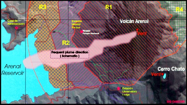 |
Figure 108. A map showing Arenal's permanent SO2 monitoring stations (stars), the administrative facility where telemetered gas data are received ("Casa de Administration"), the typical plume direction, and some other geographic details. N is towards the top; for scale, the N-S distance between grid lines is 2 km. Courtesy of OVSICORI-UNA. |
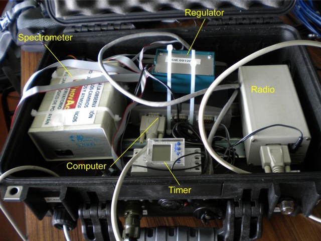 |
Figure 109. Some of the key components of the SO2 monitoring stations deployed at Arenal volcano (and Turrialba). These systems enable scientists to measure SO2 concentration-pathlengths, weather permitting, during daylight hours. When combined with wind-speed data, SO2 fluxes may be calculated. Courtesy of Eliecer Duarte, OVSICORI-UNA. |
The systems employ an upward-looking scanner, which sits outside the box, and sends signals to the spectrometer. Based on peaks at diagnostic wavelengths, the computer calculates the resulting SO2 concentration-pathlength. The measurements are initially transmitted by radio to a common point between the stations. There, internet linkages enable the measurements to proceeded to the Observatory.
The SO2 monitoring instrument's sampling rate can vary from 1 per second to 10 per second depending on the detection of a plume and its concentration-pathlength. The technique, which uses scattered sunlight, is only effective during daylight. It employs a 12-V battery recharged with a solar panel. During cloudy conditions, the instrument only collected 2-5 hours of good data per day. There was a combined total of six stations operating at Arenal and Turrialba. During the course of two years there were two monitoring stations vandalized. Despite these challenges, the systems have helped assess the scale of the degassing problem.
Satellite thermal alerts. Since 1 July 2008, MODVOLC satellite thermal alerts occurred 12 times during the rest of 2008. The bulk took place between 31 August and 25 October, only once in 2009 (two pixels on 24 December), and three times in 2010 through 15 September.
Geological Summary. Conical Volcán Arenal is the youngest stratovolcano in Costa Rica and one of its most active. The 1670-m-high andesitic volcano towers above the eastern shores of Lake Arenal, which has been enlarged by a hydroelectric project. Arenal lies along a volcanic chain that has migrated to the NW from the late-Pleistocene Los Perdidos lava domes through the Pleistocene-to-Holocene Chato volcano, which contains a 500-m-wide, lake-filled summit crater. The earliest known eruptions of Arenal took place about 7000 years ago, and it was active concurrently with Cerro Chato until the activity of Chato ended about 3500 years ago. Growth of Arenal has been characterized by periodic major explosive eruptions at several-hundred-year intervals and periods of lava effusion that armor the cone. An eruptive period that began with a major explosive eruption in 1968 ended in December 2010; continuous explosive activity accompanied by slow lava effusion and the occasional emission of pyroclastic flows characterized the eruption from vents at the summit and on the upper western flank.
Information Contacts: Observatorio Vulcanologico Sismologica de Costa Rica-Universidad Nacional (OVSICORI-UNA), Apartado 86-3000, Heredia, Costa Rica (URL: http://www.ovsicori.una.ac.cr/); Instituto Costarricense de Electricidad (ICE), Apartado 10032-1000, San José, Costa Rica; Chalmers University of Technology, Department of Earth and Space Science, Göteborg, Sweden; Agence France-Presse (URL: http://www.afp.com/afpcom/en/); Nacion.com, Apartado 10138-1000 San José, Costa Rica (URL: http://wvw.nacion.com/); Tico Times, Apartado 4632-1000, San José, Costa Rica (URL: http://www.ticotimes.net/).