Report on Avachinsky (Russia) — August 2010
Bulletin of the Global Volcanism Network, vol. 35, no. 8 (August 2010)
Managing Editor: Richard Wunderman.
Avachinsky (Russia) Shallow earthquakes in 2005; plume in 2008
Please cite this report as:
Global Volcanism Program, 2010. Report on Avachinsky (Russia) (Wunderman, R., ed.). Bulletin of the Global Volcanism Network, 35:8. Smithsonian Institution. https://doi.org/10.5479/si.GVP.BGVN201008-300100
Avachinsky
Russia
53.256°N, 158.836°E; summit elev. 2717 m
All times are local (unless otherwise noted)
This report discusses Avachinsky in 2001-2010. Following lava flows emitted in 1991 (BGVN 16:12), Avachinsky generated near-daily fumarolic plumes and generally low (background) seismicity (figure 3). The escaping gases contained sufficient sulfur to construct an area of sulfurous deposits at a prominent NW-trending crack on the SW rim of the summit crater. In 2001 a series of minor earthquakes were sometimes accompanied by gas-and-steam plumes (some with ash) (BGVN 26:11). Weak fumarolic activity and small mudflows also were observed.
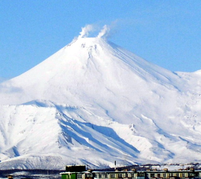 |
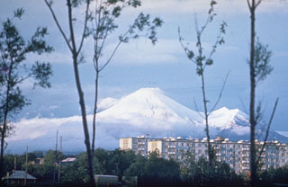
Figure 3. View of Avachinsky volcano from the W on 24 March 2004. From Droznin and others (2004?). |
By November 2001, seismic activity had declined to background levels where it apparently remained until 2005. On 8 November 2005, the Kamchatkan Volcanic Eruption Response Team (KVERT) reported that the number and energy of shallow earthquakes below Avachinsky had increased during the previous month. A weak thermal anomaly near the volcano's summit was visible on satellite imagery on 7 November. Seismicity increased significantly on 21 November, with very shallow earthquakes and several hybrid earthquakes. A weak thermal anomaly near the summit was visible on satellite imagery during 20-21 November.
During 2006 moderate fumarolic activity occurred, producing a steam plume about 700 m above crater. Seismicity was at background levels, with occasional weak seismic events at 500 m depth.
On 10 May 2008, a plume from Avachinsky rose to an altitude of 4.3 km and drifted S and E. KVERT did not detect ash by direct observation or on satellite imagery.
Cross-sectional view. A topographical profile of the volcano (figure 4) shows the inferred geothermal reservoir. The possible drill hole (dark line) and plant are only in proposal stages.
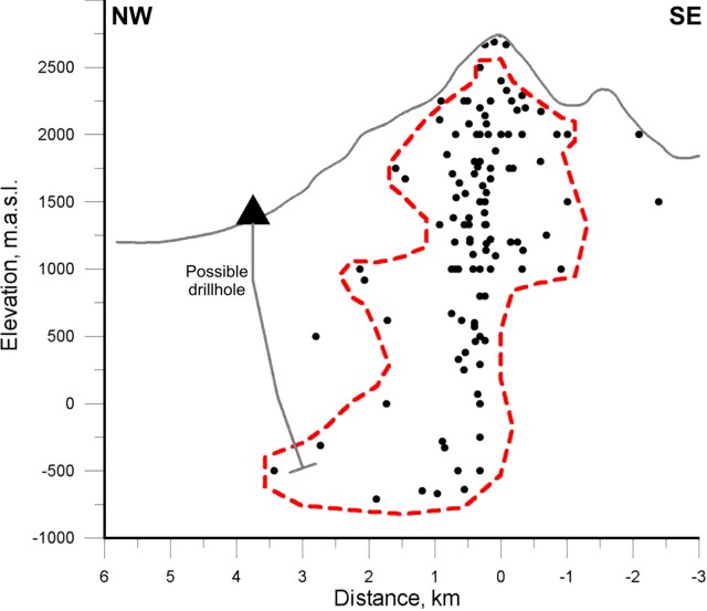 |
Figure 4. Inferred boundaries of geothermal reservoirs (dashed line) in vertical cross-sections of the Avachinsky volcano. Circles depict earthquake hypocenters associated with a steam eruption in 2001 (data from four stations, Kamchatka EMSD GS RAS). From Droznin and others (2004?). |
Droznin and others (2004?) note that "The heat discharge of the fumaroles may be estimated based on the geometrical characteristics of their clouds, taking into account local meteorological conditions.... The Avachinsky volcano fumaroles have been monitored since 2003 for the purpose of using the size of the fumaroles clouds to estimate the corresponding heat discharge. Its worth noting, that the real size of the thermo-clouds may be estimated only when there is 100% air saturation.
"The October 2001 eruption revealed an active steam-dominated reservoir below the lava plug of 1991. The swarm of the earthquakes hypocenters synchronized with the eruption 2001, showing the true geometrical size of the steam-dominated reservoir [figure 4]. This 1-km radius reservoir extends from the elevation of the lava plug at 2,750 m a.s.l. to -1,000 m a.s.l., where some north east trend shifting of the reservoir occurs. Similar earthquake distributions were detected in 2004."
Reference. Droznin, V.A., Dubrovskaya, I.K., Kiryukhin, A.V., Chernykh, E.V., Senyukov, S.L., and Ivanysko G.O., 2004(?), Avachinsky volcano geothermal reservoir based on fumaroles activity and seismological network data; (undated) Report of the Institute of Volcanology FEB RAS, Piip-9, Petropavlovsk-Kamchatsky, Russia, 683006.
Geological Summary. Avachinsky, one of Kamchatka's most active volcanoes, rises above Petropavlovsk, Kamchatka's largest city. It began to form during the middle or late Pleistocene, and is flanked to the SE by Kozelsky volcano, which has a large crater breached to the NE. A large collapse scarp open to the SW was created when a major debris avalanche about 30,000-40,000 years ago buried an area of about 500 km2 to the south, underlying the city of Petropavlovsk. Reconstruction of the volcano took place in two stages, the first of which began about 18,000 years before present (BP), and the second 7,000 years BP. Most eruptions have been explosive, with pyroclastic flows and hot lahars being directed primarily to the SW by the collapse scarp, although there have also been relatively short lava flows. The frequent historical eruptions have been similar in style and magnitude to previous Holocene eruptions.
Information Contacts: Kamchatka Volcanic Eruptions Response Team (KVERT), Far East Division, Russian Academy of Sciences, 9 Piip Blvd., Petropavlovsk-Kamchatsky, 683006, Russia (URL: http://www.kscnet.ru/ivs/); Tokyo Volcanic Ash Advisory Centre, Tokyo, Japan (URL: http://ds.data.jma.go.jp/svd/vaac/data/); Kamchatkan Experimental and Methodical Seismological Department (KEMSD), Geophysical service, Russian Academy of Science (URL: http://www.emsd.iks.ru/index-e.php).