Report on Montagu Island (United Kingdom) — September 2010
Bulletin of the Global Volcanism Network, vol. 35, no. 9 (September 2010)
Managing Editor: Richard Wunderman.
Montagu Island (United Kingdom) Quiet, with minor thermal anomalies, since September 2007
Please cite this report as:
Global Volcanism Program, 2010. Report on Montagu Island (United Kingdom) (Wunderman, R., ed.). Bulletin of the Global Volcanism Network, 35:9. Smithsonian Institution. https://doi.org/10.5479/si.GVP.BGVN201009-390081
Montagu Island
United Kingdom
58.445°S, 26.374°W; summit elev. 1370 m
All times are local (unless otherwise noted)
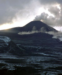
As of late October 2010, Montagu Island displayed only very localized and minor thermal anomalies of insufficient size to indicate an eruption. As previously reported, Montagu Island displayed frequent thermal anomalies, several lava flows, and a low-level ash plume in December 2006, but eruptions ceased after September 2007 (BGVN 33:03 and 33:07).
MODVOLC thermal anomalies have remained absent between September 2007 and 31 October 2010, and ASTER thermal images over the past few years lacked indication of eruptive activity. The most recent cloud-free ASTER image (figure 21) shows relatively small thermal anomalies on the 2005 flow field that Patrick believes likely represent fumaroles venting residual heat from the lava flow.
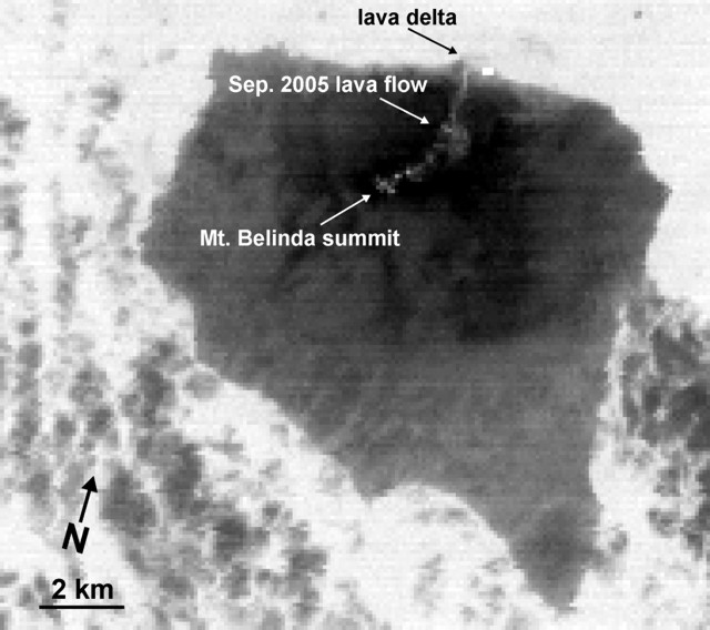 |
Figure 21. ASTER image of Montagu Island taken on 21 March 2010 showing the 2005 lava flow from Mt. Belinda. As of late October 2010, this was the most recent cloud-free ASTER image of Montagu Island (based on Aster band 14, 11-micron wavelength). Courtesy of Matt Patrick (USGS) and the ASTER project. |
According to Matt Patrick (USGS), several small (1-2 pixels in size) thermal anomalies are situated near the summit of Mt. Belinda on the proximal section of the 2005 flow. In addition, a larger (3 x 2 pixels) anomaly is at the E end of the delta formed in 2005 when lava entered the ocean. Patrick notes that this thermal anomaly on the delta has been present in ASTER images going back to 2008 and, as with the anomaly above, likely indicates residual heat escape.
Geological Summary. The largest of the South Sandwich Islands, Montagu consists of a massive shield volcano cut by a 6-km-wide ice-filled summit caldera. The summit of the 11 x 15 km island rises about 3,000 m from the sea floor between Bristol and Saunders Islands. Around 90% of the island is ice-covered; glaciers extending to the sea typically form vertical ice cliffs. The name Mount Belinda has been applied both to the high point at the southern end of the summit caldera and to the young central cone. Mount Oceanite, an isolated peak at the SE tip of the island, was the source of lava flows exposed at Mathias Point and Allen Point. There was no record of Holocene activity until MODIS satellite data, beginning in late 2001, revealed thermal anomalies consistent with lava lake activity. Apparent plumes and single anomalous pixels were observed intermittently on AVHRR images from March 1995 to February 1998, possibly indicating earlier volcanic activity.
Information Contacts: Matthew R. Patrick, Hawaiian Volcano Observatory (HVO), U.S. Geological Survey, PO Box 51, Hawai'i National Park, HI 96718, USA (URL: https://volcanoes.usgs.gov/observatories/hvo/); Hawai'i Institute of Geophysics and Planetology (HIGP) Thermal Alerts System, School of Ocean and Earth Science and Technology (SOEST), Univ. of Hawai'i, 2525 Correa Road, Honolulu, HI 96822, USA (URL: http://modis.higp.hawaii.edu/); ASTER (Advanced Spaceborne Thermal Emission and Reflection Radiometer), Earth Remote Sensing Data Analysis Center (ERSDAC) in Japan, and the Jet Propulsion Laboratory in the U.S. (URL: http://asterweb.jpl.nasa.gov/).