Report on Kirishimayama (Japan) — December 2010

Bulletin of the Global Volcanism Network, vol. 35, no. 12 (December 2010)
Managing Editor: Richard Wunderman.
Kirishimayama (Japan) Large eruption of Shinmoe-dake begins in January 2011
Please cite this report as:
Global Volcanism Program, 2010. Report on Kirishimayama (Japan) (Wunderman, R., ed.). Bulletin of the Global Volcanism Network, 35:12. Smithsonian Institution. https://doi.org/10.5479/si.GVP.BGVN201012-282090
Kirishimayama
Japan
31.934°N, 130.862°E; summit elev. 1700 m
All times are local (unless otherwise noted)
Setsuya Nakada (Volcano Research Center, University of Tokyo) reported that Subplinian and Vulcanian explosions occurred in the Kirishima Volcano Group in mid-January and at least as late as early February 2011. The event followed a year of inflation. The eruption occurred at Shinmoe-dake (Shinmoedake) volcano and included both airfall ash as well as the the birth and rapid growth of a lava dome. Small pyroclastic flows occurred, and over 1,000 residents evacuated.
After its 22 August 2008 eruption (BGVN 33:09), Shinmoe-dake went on to generate small phreatic explosions. These explosions took place on 15 November 2009 and 30 March, 11 April, and 27 May 2010.
Inflation preceded the 2011 eruption. the Geographical Survey Institute of Japan evaluated global positioning system (GPS) data for one year before the 2011 eruption. They found sufficient inflation to indicate the injection of 20 x 106 m3 of material.
According to the Japan Meteorological Agency (JMA), the eruption began, with a phreatomagmatic explosion from Shinmoe-dake on 19 January 2011. It produced a shock wave detected 12 km NE of the volcano, and an ash plume drifted SE. Ashfall up to 5 mm thick was reported in Miyakonojo (30 km SE) and in Nichinan City (60 km SE). Nakada reported that products of that explosion contained ~10% juvenile pumice.
Another explosion on 22 January 2011 ejected material 200 m above the vent. Based on reports from JMA and pilot observations, the Tokyo Volcanic Ash Advisory Center (VAAC) reported that ash plumes rose to altitudes of 1.8-2.1 km and drifted SE.
A third explosion began at 0731 on 26 January, and Subplinian explosions occurred at 1850 on 26 January, at 1541 on 27 January, and at 1247 on 28 January. Volcanic ash was emitted continuously until 30 January, when lava covered the crater floor.
The heights of the three major explosions during 26-28 January, confirmed with Doppler radar by JMA, were up to 8.5 km above the crater. Ashfall deposits were found ~17 cm thick at a distance of ~3 km SW of the crater, and ~8 cm thick at a distance of ~6 km from the crater.
Figures 11 and 12 are photos taken on 27 January amid the three major explosions of 26-28 January.
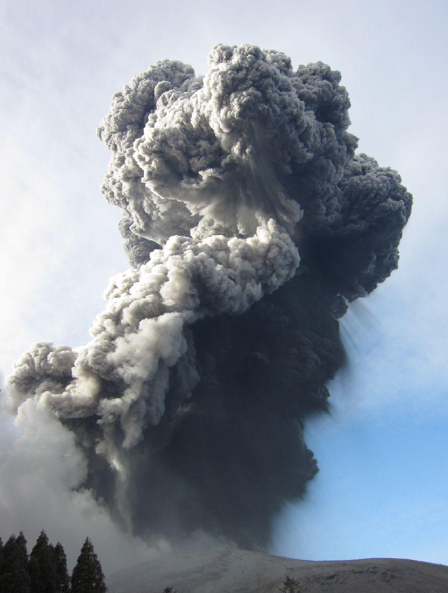 |
Figure 11. Eruption column generated by an explosion at 1541 on 27 January 2011 at Kirishima's Shinmoedake crater. Taken ~3 km SW of the crater by Setsuya Nakada. |
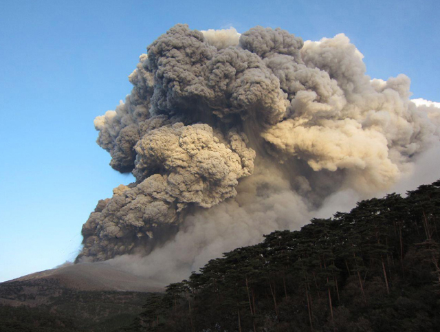 |
Figure 12. Continuously emitted Subplinean eruption cloud from Kirishima's Shinmoedake crater seen in the late afternoon of 27 January 2011. Taken from 3 km WSW of the crater by S. Nakada. |
According to the Earthquake Research Institute (ERI), the explosion on 26 January 2011 prompted JMA to raise the Alert Level to 3 (on a scale of 1-5). Lightning in the ash plume was visible in video footage that same day. Based on reports from JMA, analyses of satellite imagery, and pilot observations, the Tokyo VAAC reported that on 27 January ash plumes rose to altitudes of 1.8-2.1 km and drifted SE. According to news articles, tephra fell as far away as 8 km on 27 January and disrupted flights and train service. Some people in Miyazaki (55 km E from the volcano) voluntarily evacuated, and about 30 people in Takaharu (15 km E) spent the night in an evacuation center.
On 28 January, a small lava dome 200 m in diameter appeared on the crater floor near the vent (figure 13). In three days, it grew to ~600 m in diameter and attained a volume of more than 107 m3. ALOS satellite images disclosed that the dome grew to the point where it completely covered the active vent. Figure 14 shows the concentrically ringed and steaming lava dome on the crater floor as it appeared on 30 January.
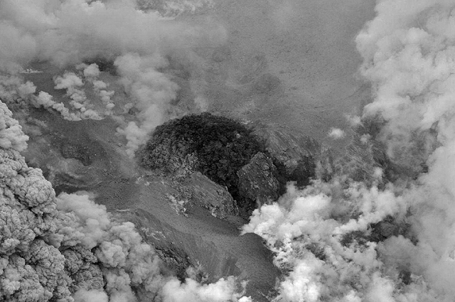 |
Figure 13. Lava dome within Kirishima's Shinmoe-dake crater, which appeared in the center of the crater floor, near the crater that produced Subplinian explosions (to the right in this photo). Taken by S. Nakada on 28 January 2011. |
During an overflight on 29 January 2011, scientists from the ERI observed freshly erupted dome material on the crater floor and saw that the crater lake was gone. Fresh pyroclastic flow deposits in the SW crater had runout distances of 500-600 m.
On the night of 31 January, 1,158 people who lived in the Takaharu Town, ~12 km W of the crater and subject to potential pyroclastic flows, were ordered to evacuate due to a possibility of a Plinian explosion. As of 5 February, 73 people who lived less than 8 km from the crater were still in the process of evacuating.
A Vulcanian explosion started on 1 February 2011, destroying part of the dome. Volcanic ash rose about 7 km above the crater, according to JMA. Large ballistics 0.7 m in diameter landed 3.2 km W of the crater. Authorities established a zone of limited access within 4 km the crater. During subsequent Vulcanian explosions, the dome stopped growing. Its morphology flattened, and it became covered with its own ejecta.
Strong steam emanated from the dome's center on 4 February (figure 14). That day, Japan's Prime Minister delivered an address on the eruption at a meeting of government officials. They outlined responses and approaches to the crisis, including expanding the hazard zone, evacuation routes, countermeasures to lahars, and the danger of pyroclastic flows.
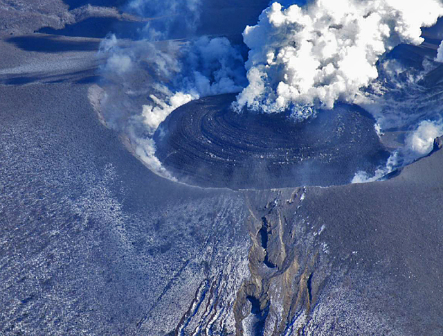 |
Figure 14. Westerly view of the lava dome growing in Kirishima's Shinmoe-dake crater on 31 January 2011. Courtesy of Tetsuo Kobayashi (Kagoshima University). |
Pumice from this eruption was composed of pyroxene-bearing andesite (57 to 62% SiO2), showing mingling of two magmas with different colors. The progress of this eruption seemed similar, Nakada noted, to the early stage of the volcano's 1716-1717 eruption. That eruption included a 3-month explosive phase, including five events with pyroclastic flows, for a total volume of erupted products amounting to 67 km3 DRE ('dense-rock equivalent,' the volume assuming no porosity, i.e., no bubbles). That eruption lasted for 1½ years (Imura and Kobayashi, 1991).
The eruption was studied from many perspectives, including satellite, seismic, magnetometer, GPS, tiltmeter, and infrasonic. Significant illustrations of data relating to the eruption have emerged, describing spatial distribution of plumes and deposits, geophysical, geochemical, petrographic, and other information only briefly covered here (ERI, 2011). Outstanding still and video images of the eruption appeared widely in the news and on the internet. No fatalities were cited in news reports accessed at press time in late February 2011.
References. ERI, 2011, Eruption of Shinmoe-dake (Kirishima volcano group), Japan, 2011; Earthquake Research Institute (ERI), Univ. of Tokyo (URL: outreach.eri.u-tokyo.ac.jp/eqvolc/201101_shinmoe/eng/).
Imura, R. and Kobayashi, T., 2001, Geological map of Kirishima Volcano (1:50,000), Geological Survey of Japan.
Imura, R. and Kobayashi, T., 1991. Eruptions of Shinmoedake Volcano, Kirishima Volcano Group, in the last 300 years, Bulletin of Volcanological Society of Japan, v. 36, pp.135-148 (in Japanese with abstract in English).
Geological Summary. Kirishimayama is a large group of more than 20 Quaternary volcanoes located north of Kagoshima Bay. The late-Pleistocene to Holocene dominantly andesitic group consists of stratovolcanoes, pyroclastic cones, maars, and underlying shield volcanoes located over an area of 20 x 30 km. The larger stratovolcanoes are scattered throughout the field, with the centrally located Karakunidake being the highest. Onamiike and Miike, the two largest maars, are located SW of Karakunidake and at its far eastern end, respectively. Holocene eruptions have been concentrated along an E-W line of vents from Miike to Ohachi, and at Shinmoedake to the NE. Frequent small-to-moderate explosive eruptions have been recorded since the 8th century.
Information Contacts: Setsuya Nakada, Volcano Research Center, Earthquake Research Institute (VRC-ERI), University of Tokyo, Yayoi 1-1-1, Bunkyo-ku, Tokyo 113, Japan (URL: http://www.eri.u-tokyo.ac.jp/topics/ASAMA2004/index-e.html); Tetsuo Kobayashi, Graduate School of Science and Engineering, Kagoshima University, Kagoshima, Japan 890-006; Japan Meteorological Agency (JMA), Otemachi, 1-3-4, Chiyoda-ku Tokyo 100-8122, Japan (URL: http://www.jma.go.jp/); Tokyo Volcanic Ash Advisory Center (VAAC), Tokyo, Japan (URL: http://ds.data.jma.go.jp/svd/vaac/data/).