Report on Rumble III (New Zealand) — February 2011
Bulletin of the Global Volcanism Network, vol. 36, no. 1 (February 2011)
Managing Editor: Richard Wunderman.
Rumble III (New Zealand) Eruption in 2009 linked to over 100 m of sea floor collapse
Please cite this report as:
Global Volcanism Program, 2011. Report on Rumble III (New Zealand) (Wunderman, R., ed.). Bulletin of the Global Volcanism Network, 36:1. Smithsonian Institution. https://doi.org/10.5479/si.GVP.BGVN201102-241130
Rumble III
New Zealand
35.745°S, 178.478°E; summit elev. -220 m
All times are local (unless otherwise noted)
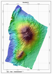
We reported in BGVN 34:07 that New Zealand scientists found evidence during a research cruise in 2009 of a recent large eruption at Rumble III, one of more than 30 big submarine volcanoes on the Kermadec Arc, NE of the Bay of Plenty on the N coast of New Zealand's North Island (figures 3 and 4). A newly available report of the 2009 cruise (Dodge, 2010) noted some new details, including the following: (1) since the last study of Rumble III volcano in 2007, significant volcanic activity had occurred; (2) the bathymetric profile of the seamount had changed since it was last mapped in 2007—the summit of Rumble III had collapsed and was ~100 m deeper, at 310 m, much of the 800-m-wide crater was filled by ash, and much of the W side of the volcano had slid down-slope; (3) volcanic flow deposits were documented in camera tows—lava boulders, hackley flow, truncated lobate or pillows, and talus were common; and (4) there was a massive abundance of ash, in particular draped across substrates in many areas, provided compelling evidence for a large eruption since 2007.
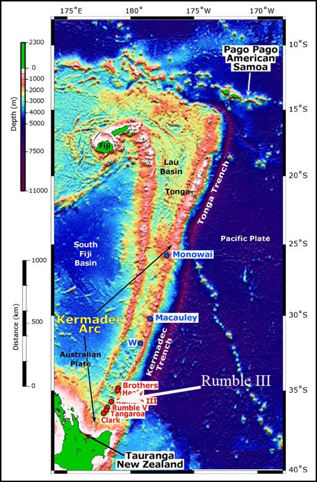 |
Figure 3. Southwest Pacific from Samoa (NE) to New Zealand (SW), showing the location of Rumble III and other submarine volcanoes along the southern Kermadec Arc. Rumble III volcano is located ~ 350 km NE of the Bay of Plenty, New Zealand, 200 km NE of Auckland, and is one of a number of submarine volcanoes that delineate the active arc front in this region. Bathymetry data were satellite-derived (for deep water) and acquired using an EM 300 multibeam echo sounder (along the arc and Lau Basin). Satellite-derived bathymetry from Sandwell and Smith (1997); EM300 bathymetry data courtesy of New Zealand National Institute of Water and Atmospheric Research (NIWA). Map courtesy of National Oceanic and Atmospheric Agency (NOAA) Ocean Explorer web site; from New Zealand American Submarine Ring of Fire 2005 expedition plan. |
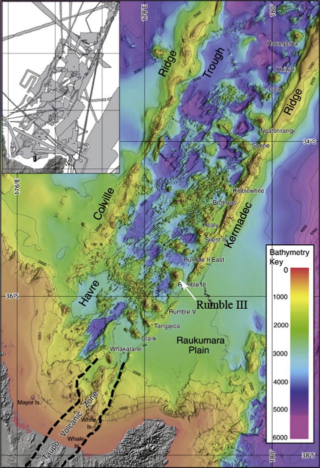 |
Figure 4. Bathymetric map of all available multibeam data as of 2009 for the Southern Havre Trough, between the Colville and Kermadec Ridges and N of the New Zealand's North Island. In the colored version of this figure, the bathymetry key (in meters) ranges from red at the surface to purple at depths of 5 to 6 km. The location of Rumble III submarine volcano is highlighted. The inset indicates the tracks and areas of individual surveys whose data comprise the map. Areas that are not covered use satellite data configured to fit the edges of multibeam data set. Courtesy of Wysoczanski and others (2010). |
A press release dated 17 August 2010 by the New Zealand National Institute of Water and Atmospheric Research (NIWA) noted that, during an oceanographic cruise aboard NIWA's research vessel R/V Tangaroa in May-June 2010, scientists confirmed that (a) the W flank of the volcano had collapsed ~100 m or more, (b) collapse of 90 m was observed at its highest (shallowest) point, and (c) as much as 120 m collapse occurred in some places. The release noted that the collapse was caused by an eruption some time in the last 2 years.
Glassy, black basaltic rock filled with vesicles was dredged from the volcano. Richard Wysoczanski (NIWA) noted that the samples are the youngest-known rocks from the Kermadec Arc region, created some time between the years 2007 and 2009. It is notable that andesite samples were previously collected from the flank of the submarine volcano by Brothers (1967). Rumble III was last mapped using multibeam technology in 2002.
NIWA principal scientist Geoffrey Lamarche said that the observation of significant pieces of sea floor moving hundreds of meters in height over a short timespan of 8 years give insight into short-time movements of the seabed. Research of the Kermadec Arc is directed in part by NIWA's survey of the area for massive sulphide deposits that sometimes develop over hydrothermal vents.
On 28 February 2011, NIWA and GNS Science announced an upcoming research cruise of about 3 weeks in 2011 to investigate mineral deposits and hydrothermal activity at five major submarine volcanoes in the Kermadec Arc (Clark, Healy, Brothers, Rumble II West, and Rumble III; see figure 4).
References. Brothers, R.N., 1967, Andesite from Rumble III Volcano, Kermadec Ridge, southwest Pacific, Bulletin of Volcanology, v. 31, no. 1, pp. 17-19.
Dodge, E., 2010, Catastrophic volcanic activity at Rumble III volcano based on EM300 bathymetry and direct sea floor imaging, Senior Thesis for Oceanography 444, University of Washington, School of Oceanography, Seattle, WA.
Smith, W. H. F., and Sandwell, D.T., 1997, Global seafloor topography from satellite altimetry and ship depth soundings, Science, v. 277, p. 1957-1962+.
Todd, E., Gill, J.B., Wysoczanski, R.J., Handler, M.R., Wright, I.C., Gamble, J.A., 2010, Sources of constructional cross-chain volcanism in the southern Havre Trough: New insights from HFSE and REE concentration and isotope systematics, Geochemistrry Geophysics Geosystems. v. 11, Q04009, 31 pp, DOI: 10.1029/2009GC002888.
Wysoczanski, R.J., Todd, E., Wright, I.C., Leybourne, M.I., Hergt, J.M., Adam, C., and Mackay, K., 2010, Backarc rifting, constructional volcanism and nascent disorganised spreading in the southern Havre Trough backarc rifts (SW Pacific), Journal of Volcanology and Geothermal Research, v. 190, issues 1-2, p. 39-57.
Geological Summary. Rumble III seamount, the largest of the Rumbles group of submarine volcanoes along the South Kermadec Ridge, rises 2,300 m from the seafloor to within about 200 m of the surface. Collapse of the edifice produced a scarp open to the west and a large debris-avalanche deposit. Fresh-looking andesitic rocks have been dredged from the summit and basaltic lava from its flanks. It has been the source of several submarine eruptions detected by hydrophone signals.
Information Contacts: Roger Matthews, North Shore City Council, 1 The Strand, Takapuna Private Bag 93500, Takapuna, North Shore City, New Zealand; Richard Wysoczanski, New Zealand National Institute of Water and Atmospheric Research (NIWA) (URL: https://www.niwa.co.nz/); Geoffrey Lamarche, NIWA (URL: https://www.niwa.co.nz/); GNS Science, Wairakei Research Centre, Private Bag 2000, Taupo 3352, New Zealand (URL: http://www.gns.cri.nz/); National Oceanic and Atmospheric Agency (NOAA) Ocean Explorer (URL: http://oceanexplorer.noaa.gov/gallery/gallery.html).