Report on Bagana (Papua New Guinea) — February 2011

Bulletin of the Global Volcanism Network, vol. 36, no. 1 (February 2011)
Managing Editor: Richard Wunderman.
Bagana (Papua New Guinea) Occasional ash plumes during 11 February-1 October 2010
Please cite this report as:
Global Volcanism Program, 2011. Report on Bagana (Papua New Guinea) (Wunderman, R., ed.). Bulletin of the Global Volcanism Network, 36:1. Smithsonian Institution. https://doi.org/10.5479/si.GVP.BGVN201102-255020
Bagana
Papua New Guinea
6.137°S, 155.196°E; summit elev. 1855 m
All times are local (unless otherwise noted)
This report discusses thermal anomalies and occasional ash plumes at Bagana during February into October 2010, with some satellite thermal data (MODVOLC) as late as early 2011. Our previous report (BGVN 35:02) also noted small lava flows, occasional ash plumes, and thermal anomalies from October 2009 through February 2010.
Historical records describe frequent eruptions since 1842. Bagana lacks instrumental monitoring and sits far from population centers. Many recent observations are remote-sensing based, although the Rabaul Volcano Observatory (RVO) produces reports with direct air- and ground-based observations. Bagana's flanks are covered with andesitic lava flows up to 50 m thick (Blake, 1968). The flows typically descend the mid-slope within the confines of tall lava levees, but emerge from the levees on the outer flanks to form sub-circular flow fields. Bagana's thick lava flows are visible [from the International Space Station] (figure 11).
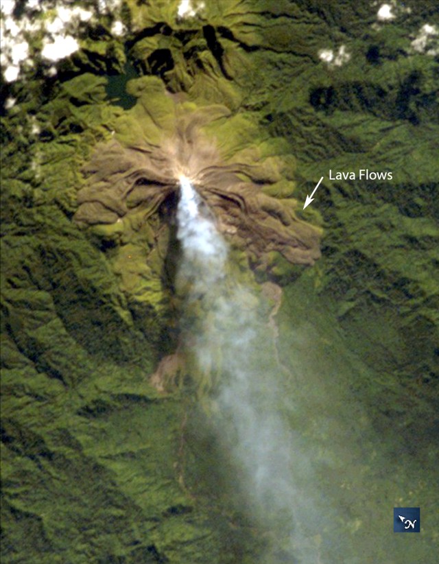 |
Figure 11. An International Space Station photo taken on 2 April 2007 showing a diffuse white vapor plume extending SSW from Bagana's summit. The volcano is known for ongoing activity and lava flows of noteworthy thickness (~50 m thick). The brown-to-olive colors of the volcano stand out amidst the green of tropical rain forest. Astronaut Photo ISS014-E-18844. Courtesy NASA. |
Activity. Between 10 February 2010 and 1 October 2010, the Darwin Volcanic Ash Advisory Center (VAAC) reported one or a few ash plumes per month from Bagana. Many rose to ~3 km and drifted from 20-205 km (table 5). According to RVO, ash plumes were seen on 5 February and night-time incandescence was seen on 2, 12, 13, and 19 February. White vapor was emitted during 1-21 February. Sulfur dioxide plumes drifted ENE during 11-20 February and NNW on 20 and 21 February. Consistent with the thick lava flows, MODVOLC detected well over 100 thermal anomalies at Bagana in the year ending 10 February 2011.
Table 5. Summary of ash plumes from Bagana reported during 1 February-October 2010. Courtesy of the Darwin Volcanic Ash Advisory Centre (VAAC).
| Date | Altitude (km) | Drift (distance and direction) |
| 11-15 Feb 2010 | 2.4 | 18-150 km E, NE |
| 19-20, 23, 25 and 27 Apr 2010 | 1.5-3 | 35-85 km S, SW, W, NW |
| 06, 10-12 May 2010 | 2.4-3 | 55-75 km W, SW, WSW |
| 25-28 May 2010 | 3 | 30-185 km NW, W, SW |
| 13-14 Jun 2010 | 3 | 75-205 km SW, W |
| 04 Jul 2010 | 2.4 | 75 km W |
| 10-11 Jul 2010 | 2.4 | 75-150 km SW |
| 13-15 Aug 2010 | 2.4 | 75 km SW, W |
| 01 Oct 2010 | 2.4 | 75 km NW |
Reference. Blake D H, 1968. Post Miocene volcanoes on Bougainville Island, Territory of Papua and New Guinea. Bull Volc, 32: 121-140
Geological Summary. Bagana volcano, in a remote portion of central Bougainville Island, is frequently active. This massive symmetrical cone was largely constructed by an accumulation of viscous andesitic lava flows. The entire edifice could have been constructed in about 300 years at its present rate of lava production. Eruptive activity is characterized by non-explosive effusion of viscous lava that maintains a small lava dome in the summit crater, although occasional explosive activity produces pyroclastic flows. Lava flows with tongue-shaped lobes up to 50 m thick and prominent levees descend the flanks on all sides.
Information Contacts: Darwin Volcanic Ash Advisory Centre (VAAC), Bureau of Meteorology, Northern Territory Regional Office, PO Box 40050, Casuarina, NT 0811, Australia (URL: http://www.bom.gov.au/info/vaac/); Rabaul Volcano Observatory (RVO), PO Box 386, Rabaul, Papua New Guinea; NASA Earth Observatory (URL: http://earthobservatory.nasa.gov/); Hawai'i Institute of Geophysics and Planetology (HIGP) MODVOLC Thermal Alerts System, School of Ocean and Earth Science and Technology (SOEST), Univ. of Hawai'i, 2525 Correa Road, Honolulu, HI 96822, USA (URL: http://modis.higp.hawaii.edu/); Image Science and Analysis Laboratory, NASA-Marshall Space Flight Center (URL: http://eol.jsc.nasa.gov).