Report on Taal (Philippines) — February 2011

Bulletin of the Global Volcanism Network, vol. 36, no. 1 (February 2011)
Managing Editor: Richard Wunderman.
Taal (Philippines) Intermittent non-eruptive unrest during 2008-2010
Please cite this report as:
Global Volcanism Program, 2011. Report on Taal (Philippines) (Wunderman, R., ed.). Bulletin of the Global Volcanism Network, 36:1. Smithsonian Institution. https://doi.org/10.5479/si.GVP.BGVN201102-273070
Taal
Philippines
14.0106°N, 120.9975°E; summit elev. 311 m
All times are local (unless otherwise noted)
As previously reported (BGVN 32:01), during the last four months of 2006 Taal displayed restlessness. This report discusses Taal seismicity, deformation, and hydrothermal behavior (steaming, and temperature changes in lake water at Main Crater) that occurred intermittently during 2008, 2010, and 2011.
Taal (also known as Talisay) is a lake-filled, 15 x 20 km caldera located on SW Luzon Island 65 km S of Manila (figure 9). The lake engulfs a large island with several thousand residents, Volcano Island, the place where all historical eruptions have vented (figures 10 and 11). Restlessness described herein was not confined to the area beneath the island.
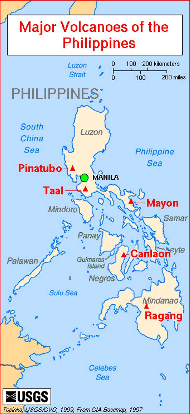 |
Figure 9. Index map of the Philippines showing Manila (the Capital) and several major volcanoes including Taal. Courtesy of Lyn Topinka (US Geological Survey). |
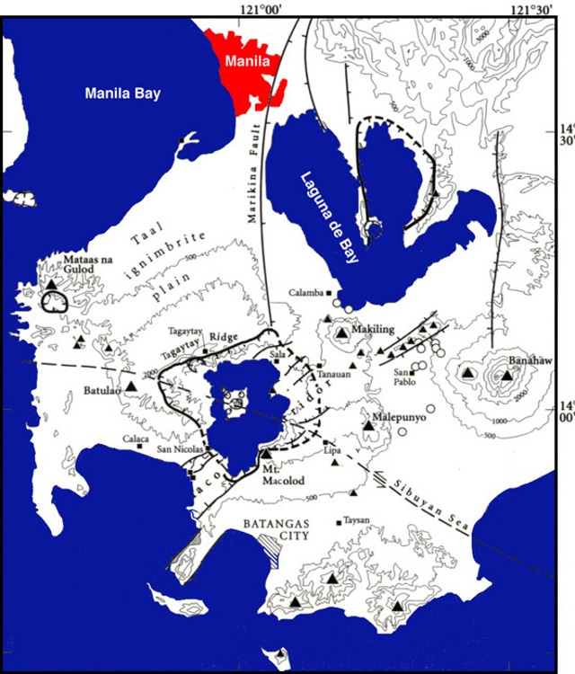 |
Figure 10. A map showing Taal caldera and surroundings. Notice that the caldera lies at the intersection of major faults and the topographic margin extends well beyond the caldera lake's margin. Courtesy of NASA Earth Observing System (EOS) Volcanology and their slide set compiled by Peter Mouginis-Mark (University of Hawaii). |
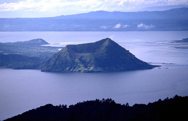 |
Figure 11. Photo of the Taal caldera lake and Volcano Island taken from the N in November 1999. Courtesy of NASA Earth Observing System (EOS) Volcanology and their slide set compiled by Peter Mouginis-Mark (University of Hawaii). |
The Philippine Institute of Volcanology and Seismology (PHIVOLCS) announced in August 2008 that seismic unrest continued. On 28 August 2008, ten volcanic earthquakes occurred, two of which were felt and heard as rumbling sounds by residents in the Pira-Piraso village on Volcano Island. The earthquakes were located NE of the island near the Daang Kastila area (below Taal caldera's N rim) at estimated depths of 0.6-0.8 km. Surface observations indicated no change in the main crater lake area. The Alert Level remained at 1 (scale is 0-5, with 0 referring to No Alert).
On 8 June 2010, PHIVOLCS raised the Alert Level for Taal to 2 because of changes in several monitored parameters that began in late April. Since 26 April, the number and magnitude of volcanic earthquakes had increased. Most signals were high-frequency earthquakes, but at least one, on 2 June, was low-frequency. Steam emissions from the N and NE sides of Main Crater occasionally intensified. Deformation data showed slight inflation since 2004; measurements taken at the SE side of Taal on 7 June showed further inflation by 3 mm.
In addition to increased seismicity, the temperature of the Main Crater Lake increased from 32°C on 11 May to 34°C on 24 May. According to PHIVOLCS, the ratios of Mg:Cl and SO4:Cl, as well as total dissolved solids in the lake, all increased. Temperature measurements of the main crater lake did not increase further, remaining between 33-34°C.
PHIVOLCS proposed that the high frequency earthquakes could be the result of active rock fracturing associated with magma intrusion beneath the volcano, and that the fractures could serve as passageways through which hot gases from the intruding magma could escape into the lake.
According to news reports (Xinhua, Philippine Daily Inquirer), the more than 5,000 residents living near Taal were advised to evacuate their homes voluntarily. On 10 June, the Philippine Coast Guard sent five teams of divers and rescue swimmers with rubber boats and medical teams to its forward command post to help evacuate, if necessary, these residents. A news report (Philippine Daily Inquirer), however, indicated that most residents refused to leave without an official order.
The number of earthquakes recorded daily gradually declined to background levels beginning the second week of July 2010. Hydrothermal activity in the N and NE sides of the main crater and Daang Kastila also decreased. Precise leveling measurements conducted during 13-21 July along the NE, SE, and SW flanks detected minimal inflation. On 2 August, PHIVOLCS lowered the Alert Level to 1.
According to PHIVOLCS, seismic activity increased during the first week of September 2010. From 1-27 September 2010, a total of 274 volcanic earthquakes, or an average of 10 events/day, was recorded. However, given that field surveys conducted at the Main Crater and at the 1965-1977 "New Eruption" site (SW edge of Main Crater) indicated no anomalous thermal or surface activity.
PHIVOLCS reported that a December 2010 deformation survey showed slight inflation compared to a September 2010 survey. Field observations on 10 and 18 January revealed no significant changes. Weak steaming from a thermal area inside the main crater was noted and the lake temperature, acidity, and color were normal. During 15-16 January 2011, ten volcanic earthquakes were detected, two of which were felt by residents of Pira-Piraso, on the N side of the island. On 17 January three volcanic earthquakes were detected and on 18 January only one was reported. Between 18-30 January, up to seven daily volcanic earthquakes were detected by the seismic network.
Field observations during 23-25 January 2011 revealed an increase in the number of steaming vents inside the main crater and a drop in the lake level there. The lake water temperature and pH values remained normal. Visual observations on 27 January showed weak steaming at a thermal area in the crater.
Geological Summary. Taal is one of the most active volcanoes in the Philippines and has produced some powerful eruptions. The 15 x 20 km Talisay (Taal) caldera is largely filled by Lake Taal, whose 267 km2 surface lies only 3 m above sea level. The maximum depth of the lake is 160 m, with several submerged eruptive centers. The 5-km-wide Volcano Island in north-central Lake Taal is the location of all observed eruptions. The island is composed of coalescing small stratovolcanoes, tuff rings, and scoria cones. Powerful pyroclastic flows and surges have caused many fatalities.
Information Contacts: Philippine Institute of Volcanology and Seismology (PHIVOLCS), University of the Philippines Campus, Diliman, Quezon City, Philippines (URL: http://www.phivolcs.dost.gov.ph).Pete Mouginis-Mark, Hawai'i Institute of Geophysics and Planetology (HIGP) Thermal Alerts System, School of Ocean and Earth Science and Technology (SOEST), Univ. of Hawai'i, 2525 Correa Road, Honolulu, HI 96822, USA (URL: http://eos.higp.hawaii.edu/ppages/pinatubo/8.taal/?); Xinhua (URL: http://www.xinhuanet.com/english2010); Philippine Daily Inquirer (URL: http://www.inquirer.net/).