Report on Arenal (Costa Rica) — April 2011

Bulletin of the Global Volcanism Network, vol. 36, no. 4 (April 2011)
Managing Editor: Richard Wunderman.
Edited by Julie A. Herrick.
Arenal (Costa Rica) Activity and seismicity decrease; new analysis of acid-rain
Please cite this report as:
Global Volcanism Program, 2011. Report on Arenal (Costa Rica) (Herrick, J.A., and Wunderman, R., eds.). Bulletin of the Global Volcanism Network, 36:4. Smithsonian Institution. https://doi.org/10.5479/si.GVP.BGVN201104-345033
Arenal
Costa Rica
10.463°N, 84.703°W; summit elev. 1670 m
All times are local (unless otherwise noted)
Our previous report about Arenal discussed ongoing sporadic eruptive behavior, preliminary information about the 24 May 2010 dome collapse, and the higher frequency of rockfalls through September 2010 (BGVN 35:07). Since October 2010, volcanic activity at Arenal appears to be decreasing. Events like the explosion on 24 July 2010, discussed below (see figure 110) have become rare. Reports from Costa Rica's Volcanological and Seismological Observatory and National University (OVSICORI-UNA) include direct observations of summit activity, seismic analysis, and acid-rain data and provide the basis for this report covering the 24 May, 2010 event in addition to activity from October 2010 to May 2011.
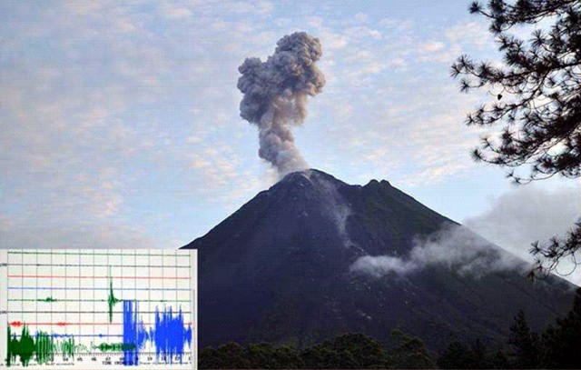 |
Figure 110. At 0538 on 24 July 2010 (local time) an ash explosion at Arenal was recorded seismically and its resulting cloud was photographed. In the lower left-hand corner is the seismic trace of the event, which began suddenly and saturated the record (seismic station VACR; OVSICORI-UNA). Courtesy of Phil Slosberg (OVSICORI-UNA). |
Incandescent avalanche of 24 May 2010. Sudden activity down Arenal's SW flank on 24 May 2010 produced long, incandescent avalanches and pyroclastic flows, forcing the National Park to evacuate visitors on this day. No injuries or damage to infrastructure had been reported during Arenal's activity in May 2010. Previous pyroclastic events had also caused evacuations in June 2009, June 2008, and September 2007.
Beginning at noon on 24 May, incandescent avalanches descended from the summit dome. They affected a sector that has been subject to avalanches in the last 3 years (see figure 111). A field investigation by OVSICORI on 31 May found that material fell from the summit down to 1,200 m elevation and accumulating in a toe 400 m x 80 m. The majority of blocks surpassed 2 m in diameter. Deposits from the dome collapse were still hot when they arrived at the forest that borders Río Agua Caliente. The OVSICORI-UNA field report of 31 May 2010 contains photos and additional details. Several sections of the river scarp show signs of being struck and eroded by direct impact of the incandescent blocks that arrived with high speed. The dome that supplied the block-and-ash flows became visibly deflated but activity culminated through the week with the formation of a new dome toward the E side of the summit. The formation and destruction of domes at the top of Crater C is very common. These domes reach ten's of meters in size and frequently collapse violently, especially when they are destabilized at the crater rim.
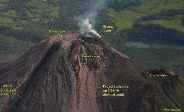 |
Figure 111. Changes in morphology at Arenal's Crater C are visible owing to the 24 May 2010 dome collapse. Located on the eastern side of the summit, the point of failure was attributed to the "Unstable area." Courtesy of E. Duarte (OVSICORI-UNA). |
Decreasing activity. The number of explosive events peaked in February 2010, became regular up to October, but since mid-October they have become sporadic. No lava flows or night-time incandescence was observed on the flanks. Gas emission continued at the active Crater C and fumarolic activity was continuous at Crater D, the pre-1968 summit crater.
Acid-rain affected Arenal's flanks and the NE, E, and SE flanks showed a loss of vegetation. These conditions plus the high amounts of rainfall aggravated erosion on the steep slopes; rockfalls and landslides continued to occur in these valleys: Calle de Arenas, Manolo, Guillermina, and Río Agua Caliente. OVSICORI-UNA released a report on acid-rain measurements that began on 9 April 2003 and ended on 30 November 2010; data from four stations showed generally decreasing acidity with time (figure 112). The trend steadily increased from pH ~4 to ~4.5 for all stations. Although irregular spikes are recorded, the low outliers were generally less acidic with time.
|
Figure 112. Variation of the pH (level of acidity) of rain-water collected from four stations on Arenal. Data points represent measurements from 9 April 2003 to 30 November 2010. Courtesy of OVSICORI-UNA. |
Waldo Taylor assessed seismic data from the local network. The 2010 mid-year ICE report discussed seismicity and the general trend shown in table 26. The large spike in seismic events from 2009 dropped off abruptly the following year.
Table 26. Earthquakes counted at Arenal during 2005-2010. Courtesy of ICE.
| Year | Number of earthquakes |
| 2005 | 3 |
| 2006 | 12 |
| 2007 | 15 |
| 2008 | 47 |
| 2009 | 239 |
| 2010 | 56 |
Gerardo J. Soto discussed Arenal seismicity. "In general terms, the average magnitude increased from 2.0 in 2006 to 2.3 in 2010. The biggest was M 4.1 in 1 November 2009. Mean [focal] depth deepened from 5.5 km in 2006 to about 2 km in 2010. Most of them were between 2 and 5 km deep in 2009-2010, and down to 9 km deep in 2010.
"The number of [respective] earthquakes from September through December 2010 decreased monthly [in the sequence] 24, 12, 9, 3. Epicenters shifted from SE to NW quadrangle of the volcano through time.
"We preliminarily interpret this as a possible withdrawal of magma below the volcano, [on the basis of] focal mechanisms."
Secondary hazards. With Arenal's decrease in explosive activity, no ash collection has been possible this year (2011). A network of seven stations exists for regular sampling. The most effusive event occurred in 1968 when roughly 2 x 10⁵ metric tons of ash fell on the flanks. Later, a hydroelectric project was completed in the 1970s and filled the basin below the volcano with 2.416 x 10⁶ m3 of water (the maximum storage capacity), forming Lake Arenal. From 1992 to 1997, the annual sediment load into the lake contained 1.4% remobilized material from Arenal.
Future activity at Arenal within the next 100 years may include large eruptions with the potential to produce 10 million metric tons of volcanic sediments; within the next 200 years an extreme event could contribute 107 metric tons of volcaniclastics to Lake Arenal (Soto, 1998). The distribution of volcaniclastic sediments is largely controlled by the Río Agua Caliente, a drainage connecting tributaries from Arenal's southern flank. Roughly every 2-5 years there are relatively large debris flows along this river. As recently as the first week of May 2011, intense flooding damaged a bridge by severely undermining the concrete abutments (G.J. Soto, personal communication).
Satellite thermal alerts. Since 15 September 2010 there have been no MODVOLC satellite thermal alerts through February 2011.
References. Soto, G.J., 1998, Cálculo de ceniza eyectada por el Volcán Arenal y ceniza caída en el embalse durante el período 1992-1997; Informe OSV.98.05.ICE, 18 pp. (in Spanish)
OVSICORI-UNA, 2010, Cambios Morfológicos y Avalanchas Incandescentes del 24 de Mayo en el Volcán Arenal. (in Spanish) (URL: http://www.ovsicori.una.ac.cr/vulcanologia/informeDeCampo/2010/InfcampAremayo10.pdf)
Geological Summary. Conical Volcán Arenal is the youngest stratovolcano in Costa Rica and one of its most active. The 1670-m-high andesitic volcano towers above the eastern shores of Lake Arenal, which has been enlarged by a hydroelectric project. Arenal lies along a volcanic chain that has migrated to the NW from the late-Pleistocene Los Perdidos lava domes through the Pleistocene-to-Holocene Chato volcano, which contains a 500-m-wide, lake-filled summit crater. The earliest known eruptions of Arenal took place about 7000 years ago, and it was active concurrently with Cerro Chato until the activity of Chato ended about 3500 years ago. Growth of Arenal has been characterized by periodic major explosive eruptions at several-hundred-year intervals and periods of lava effusion that armor the cone. An eruptive period that began with a major explosive eruption in 1968 ended in December 2010; continuous explosive activity accompanied by slow lava effusion and the occasional emission of pyroclastic flows characterized the eruption from vents at the summit and on the upper western flank.
Information Contacts: Phil Slosberg and Eliecer Duarte, Observatorio Vulcanologico Sismologica de Costa Rica-Universidad Nacional (OVSICORI-UNA), Apartado 86-3000, Heredia, Costa Rica (URL: http://www.ovsicori.una.ac.cr/); Gerardo J. Soto, Instituto Costarricense de Electricidad (ICE), Apartado 10032-1000, San José, Costa Rica; Waldo Taylor, Sismológico y Vulcanológico de Arenal y Miravalles (OSIVAM), Oficina de Sismología y Vulcanología (OSV), Instituto Costarricense de Electricidad (ICE), Apartado 10032-1000, San José, Costa Rica.