Report on Irazu (Costa Rica) — April 2011

Bulletin of the Global Volcanism Network, vol. 36, no. 4 (April 2011)
Managing Editor: Richard Wunderman.
Edited by Julie A. Herrick.
Irazu (Costa Rica) Crater lake dries and regional acid-rain report
Please cite this report as:
Global Volcanism Program, 2011. Report on Irazu (Costa Rica) (Herrick, J.A., and Wunderman, R., eds.). Bulletin of the Global Volcanism Network, 36:4. Smithsonian Institution. https://doi.org/10.5479/si.GVP.BGVN201104-345060
Irazu
Costa Rica
9.979°N, 83.852°W; summit elev. 3436 m
All times are local (unless otherwise noted)
In April 2010 the lake within Irazú's crater dwindled to only a few centimeters depth and from May to August the lake was dry enough to allow plants to grow up to 10 cm high. Water began to accumulate in September 2010 but disappeared again during the following month. Since November 2010 water returned to the crater and as late as April 2011, a shallow turquoise-blue lake was maintained. Continuous monitoring of acid rain on Irazú's flanks reflected contributions from Turrialba. Often called Irazú's "twin volcano," Turrialba is less than 10 km to the ENE and during the past 4 years it has caused a region-wide increase in acid rain. Covering January 2004 through September 2007, the last Bulletin report on Irazú (BGVN 32:11) highlighted decreasing lake levels, fumarolic changes, and minor mass wasting on the crater walls during January 2004 to March 2007 (see table 8 for a summary of lake changes).
Table 8. Changing lake conditions based on observations of Irazú's crater. Double asterisks indicate times when the lake disappeared; "--" fills cells where no data is available; lake levels are reported qualitatively except for the 7 October to 12 March 2010 time interval when absolute values were measured. This summary is based on ICE data and OVSICORI Monthly Reports.
| Date | Lake level | Temp. °C | Water color | Notes |
| ** Apr 1990 | Empty | -- | -- | -- |
| 1991-1994 | Stable | -- | green | Infrequent Bubbles |
| 08 Dec 1994 | ~VEI 2 explosion from the NW outer flank fumarole~ | -- | -- | -- |
| 1994-1996 | Stable | -- | green | Bubbles |
| May 2000 | Decreasing | 18 | yellow-green | Bubbles |
| Jan 2001 | ~30 | -- | green | Bubbles |
| 08 Feb 2003 | Stable | 15 | reddish | Rockslide into lake |
| Jan-Dec 2004 | Stable | -- | green | Convection cells at edges |
| Jan-Nov 2005 | Stable | -- | green | Convection cells in center |
| Mar-Dec 2006 | Stable | -- | increasingly yellow-green | Convection cells in various locations |
| Mar-Sep 2007 | Decreasing | 145 | light-green | Convection cells at edges and center; bubbles |
| 20 Sep 2007-Mar 2008 | Decreasing | 17 | -- | Bubbles |
| 05 Mar 2008-07 Oct 2009 | Decreasing | 14 | dark green | Bubbles |
| 07 Oct 2009-12 Mar 2010 | 1.4 m | 16 | dark-to-light green | -- |
| Apr 2010 | Only few cm | -- | -- | -- |
| ** May-Aug 2010 | Empty | -- | -- | Plants on crater floor |
| Sep 2010 | Re-forming | -- | -- | -- |
| ** Oct 2010 | Empty | -- | -- | -- |
| Nov 2010-Jan 2011 | Forming | -- | turquoise | -- |
| Feb-Apr 2011 | Few meters | -- | turquoise-to-blue | -- |
On 22 July 2010 a team of investigators from Observatorio Vulcanologico Sismologica de Costa Rica-Universidad Nacional (OVSICORI-UNA) descended to the dry crater floor. They documented changes in vegetation, fumaroles, and clay deposition on the crater floor. Photos taken during prior trips provided comparisons with previous conditions (figure 14). Rockfalls and minor mass wasting had been occurring regularly and the long runout of debris across the crater floor was visible during this investigation. Most of the debris fell from the E and SW walls. On the NE side of the dry crater a rocky area emitted low temperature (24°C) sulfur-smelling gases from three aligned vents. Higher temperatures (86°C) were measured from fumaroles on the N side of the crater but they appeared to be releasing gas with less energy than observed in the past years when bubbles were visible within the lake. Another interesting finding was a waterfall on the inside of the crater on the SW wall; this small waterfall did not have sufficient volume to pool on the crater floor and instead soaked directly into the surrounding clay.
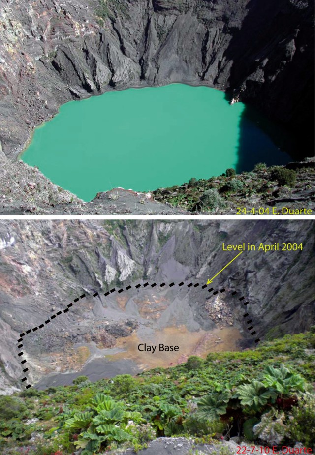 |
Figure 14. Views taken from Irazú's S rim. (top) The crater on 24 April 2004 contained a turquoise lake. (bottom) A repeat photo taken on 22 July 2010 shows the lake had disappeared; the former lake level and the clay base on the crater floor are marked. Since November 2010 water had accumulated and as of April 2011, was several meters deep. Courtesy of Eliecer Duarte, OVSICORI-UNA. |
The water level in Irazú's crater has been variable throughout time; the Bulletin recorded a dry crater during February 1977 and June 1987 (SEAN 12:07), and April 1990 (BGVN 15:04). Factors highlighted during the IAVCEI CVL-7 ("Commission of Volcanic Lakes" Costa Rica, 10-19 March 2010) included complex connections with Turrialba, seasonal effects, infiltration within the crater, and the role of mass wasting. The mechanism for the recent disappearance of the lake is still under investigation by OVSICORI-UNA and ICE investigators (Guillermo Alvarado, personal communication).
Erosion. Mass wasting had been an ongoing process for at least 10 years. Material is primarily shed from the E and SW walls and the lake contained islands of black and red material formed from the debris. In February 2003 a major rockslide into the lake caused the water color to change from green to shades of red. An analysis of seismicity during that month showed no correlation to these slope failures (BGVN 28:12). Cracks along the NW rim formed and widened since December 2007; these cracks caused blocks up to 3 x 20 m to fall from the rim in March 2008.
Local gas measurements. Since the large phreatic explosion in December 1994 (BGVN 19:12), the NW fumarole has been releasing low gas emissions regularly. Different temperature measurements recorded since June 2010 ranged between 90°C to 86°C. To monitor changes in sulfur dioxide output from Irazú, a network of three stations collected rain samples from sites along the volcano's flanks.
The pH data from September 2004 through July 2010 were plotted in the OVSICORI-UNA July 2010 monthly report. The results correlate pH changes to much larger degassing events occurring at Turrialba, a neighboring volcano that began major degassing in 2007. Only the "Borde Sur" station was sampling continuously but the other two stations reflected similar trends in acidity. Despite irregular fluctuations, a decreasing pH trend began in 2007. The lowest point of the trend was measured by "Borde Este" at approximately pH 3.25. Where there "Pacayas" station data began, the trend appeared to have stabilized between pH 3.25 and 4.75.
References. D. Rouwet, R.A. Mora-Amador, C.J. Ramírez-Umaña, G. González, Seepage of "aggressive" fluids reduce volcano flank stability: the Irazú and Turrialba case, Costa Rica, Abstract, CVL 7 Workshop Costa Rica, IAVCEI-Commission of Volcanic Lakes, March 2010.
Geological Summary. The massive Irazú volcano in Costa Rica, immediately E of the capital city of San José, covers an area of 500 km2 and is vegetated to within a few hundred meters of its broad summit crater complex. At least 10 satellitic cones are located on its S flank. No lava effusion is known since the eruption of the Cervantes lava flows from S-flank vents about 14,000 years ago, and all known Holocene eruptions have been explosive. The focus of eruptions at the summit crater complex has migrated to the W towards the main crater, which contains a small lake. The first well-documented eruption occurred in 1723, and frequent explosive eruptions have occurred since. Ashfall from the last major eruption during 1963-65 caused significant disruption to San José and surrounding areas. Phreatic activity reported in 1994 may have been a landslide event from the fumarolic area on the NW summit (Fallas et al., 2018).
Information Contacts: E. Duarte, Observatorio Vulcanologico Sismologica de Costa Rica-Universidad Nacional (OVSICORI-UNA), Apartado 86-3000, Heredia, Costa Rica (URL: http://www.ovsicori.una.ac.cr/); G. Alvarado and G.J. Soto, Oficina de Sismologia y Vulcanologia del Arenal y Miravalles (OSIVAM), Instituto Costarricense de Electricidad (ICE), Apartado 10032-1000, San Jose, Costa Rica.