Report on Gaua (Vanuatu) — May 2011
Bulletin of the Global Volcanism Network, vol. 36, no. 5 (May 2011)
Managing Editor: Richard Wunderman.
Gaua (Vanuatu) Drops in both tremor and caustic effects on vegetation after mid-2010
Please cite this report as:
Global Volcanism Program, 2011. Report on Gaua (Vanuatu) (Wunderman, R., ed.). Bulletin of the Global Volcanism Network, 36:5. Smithsonian Institution. https://doi.org/10.5479/si.GVP.BGVN201105-257020
Gaua
Vanuatu
14.281°S, 167.514°E; summit elev. 729 m
All times are local (unless otherwise noted)
The Vanuatu Geohazards Observatory (VGO) report of December 2010 noted seismicity activity and gas emissions during the period from September 2010 through 21 December 2010. This follows the more substantial emissions reported through 19 June 2010. The Ambrym report figure in BGVN 36:05 showing a 2 August 2010 satellite image of the region, includes a plume from Gaua visible for at least 80 km.
The geologic map of Vanuatu (figure 19), formerly called the New Hebrides islands, is centered ~2,200 km N off the New Zealand coast and ~2,100 km NE off the coast of Australia (figure 19). Gaua is sometimes referred to as residing on the island of Santa Maria. This island is also sometimes labeled Gaua, and volcano's topographic high is sometimes called Mont-Geret. The map locates the archepelago's major islands, volcanoes, igneous and metamorphic rocks. Most of the Pliocene and Quaternary islands have been formed by volcanic growth, with uplift in a few cases. Those islands containing older Tertiary rocks resulted from differential elevation of fault bounded blocks (Mitchel and Warden, 1971). Map revised from one on the VGO web site.
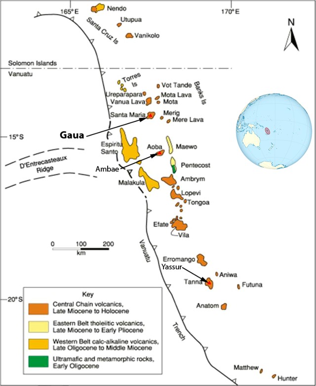 |
Figure 19. Geologic map of Vanuatu. Gaua island is labeled with its alternate name, Santa Maria (Gaua volcano is also called Mont-Geret). The volcano Ambae is situated on Aoba island; the volcano Ambrym, on Ambrym island; and the volcano Yasur, on Tanna island. The key shows basic igneous and metamorphic rock units. Those islands containing older Tertiary rocks have resulted from differential elevation of fault bounded blocks (Mitchel and Warden, 1971). Map revised from one on the VGO web site. |
Based on VGO information, the Wellington VAAC reported that on 7 and 16-19 June 2010 an ash plume from Gaua rose to an altitude of ~3 km. On 19 June the plume drifted more than 90 km W but later plume dispersal and emissions were obscured on satellite imagery.
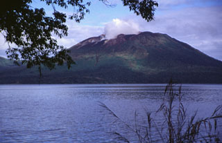
Late 2010 observations on Gaua indicated renewed growth of the vegetation near the volcano's vent and on the island's leeward W side. That area had suffered damage during April-May 2010 due to gas emissions (BGVN 35:05). These observations suggested diminished emissions from the volcano.
Since September 2010, seismic monitoring showed decreasing numbers of counts of volcano-related earthquakes (figure 20). The Alert Level of Gaua volcano was lowered to Level 1 in December 2010. No satellite thermal alerts were measured by MODVOLC during 6 April 2010 through late July 2011.
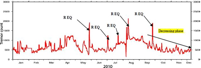 |
Figure 20. Gaua volcanic tremor counts recorded for the year 2010. REG adjacent to large pulse traces identify regional earthquakes and/or earthquakes close to Gaua unrelated to volcanic activity. Our previous report (BGVN 35:05) presented a similar plot through 22 April 2010. Courtesy of VGO. |
Reference. Mitchel, AH and Warden, AJ, 1971, Geological evolution of the New Hebrides island arc, Journal of Geological Soc. of London, October 1971, 127, p. 501-529 (DOI: 10.1144/gsjgs.127.5.0501)
Geological Summary. The roughly 20-km-diameter Gaua Island, also known as Santa Maria, consists of a basaltic-to-andesitic stratovolcano with an 6 x 9 km summit caldera. Small vents near the caldera rim fed Pleistocene lava flows that reached the coast on several sides of the island; littoral cones were formed where these lava flows reached the ocean. Quiet collapse that formed the roughly 700-m-deep caldera was followed by extensive ash eruptions. The active Mount Garet (or Garat) cone in the SW part of the caldera has three pit craters across the summit area. Construction of Garet and other small cinder cones has left a crescent-shaped lake. The onset of eruptive activity from a vent high on the SE flank in 1962 ended a long period of dormancy.
Information Contacts: Vanuatu Geohazards Observatory (VGO), Department of Geology, Mines and Water Resources (DGMWR), Vanuatu (URL: http://www.vmgd.gov.vu/vmgd/); MODIS/MODVOLC thermal alerts satellite system, Hawai'i Institute of Geophysics and Planetology (HIGP) Thermal Alerts System, School of Ocean and Earth Science and Technology (SOEST), Univ. of Hawai'i, 2525 Correa Road, Honolulu, HI 96822, USA (URL: http://modis.higp.hawaii.edu/).