Report on Ambae (Vanuatu) — May 2011

Bulletin of the Global Volcanism Network, vol. 36, no. 5 (May 2011)
Managing Editor: Richard Wunderman.
Ambae (Vanuatu) Increased degassing starting December 2009
Please cite this report as:
Global Volcanism Program, 2011. Report on Ambae (Vanuatu) (Wunderman, R., ed.). Bulletin of the Global Volcanism Network, 36:5. Smithsonian Institution. https://doi.org/10.5479/si.GVP.BGVN201105-257030
Ambae
Vanuatu
15.389°S, 167.835°E; summit elev. 1496 m
All times are local (unless otherwise noted)
Our last Bulletin report (BGVN 31:12) on Aoba (Ambae) described the destruction of vegetation by acidic gas emissions and the breach of the islet lake during 2006. This report discusses comparative quiescence into late 2009 when degassing escalated (substantial gas plumes were seen) and the hazard status rose. The volcano has remained quiet into mid-2011.
The Vanuatu region lies ~2,200 km N off the New Zealand coast and ~2,100 km NE off the coast of Australia (figure 31). A 1999 census suggested ~9,400 people resided on Ambae. Cronin and others (2004) describe the residents as "dispersed amongst more than 276 small extended family settlements and villages (Wallez 2000). Settlements are mostly restricted to the lower island slopes within 4 km of the coast. The highest population densities occur at the NE and SE ends of the island."
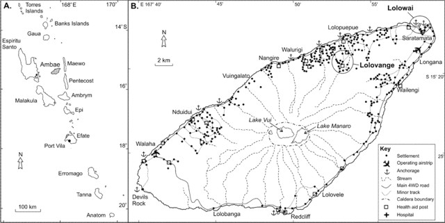 |
Figure 31. (A) Major islands of the Republic of Vanuatu. (B) Aoba (Ambae) Island, showing locations of settlements, main stream channels and roads. Cronin and others (2004) discuss the communities of Lolovange and Lolowai (ellipses). Taken from Cronin and others (2004) after work by Wallez (2000). |
The Vanuatu Geohazards Observatory (VGO) noted increases in activity from Aoba (Ambae) starting in December 2009.This began when local villagers near the volcano reported seeing a plume over the island. In December 2009 the Vanuatu Volcanic Alert Level (VVAL) was raised to Level 1. The scale ranges from 0 to 4: 0 represents normal low-level activity and 4 represents a large eruption and island wide danger. The reported source of activity is a recent cone located in the crater lake, Voui (BGVN 30:11 and 30:12).
The VGO went on to note that "An expatriate pilot based on Gaua, also witnessed a plume on Ambae on Tuesday 6th April on his way back to Gaua from Santo. Aerial pictures that were taken by two Geohazards staff on 11 April 2010 also confirmed gas emissions that were more concentrated than normal... [which] reaffirms the [Ozone Monitoring Instrument or OMI] satellite image of gas emissions above. Another observation made on Ambae is the presence of sulphur-hydromagmatic activity on the SE part of the second crater of Ambae enclosing Manaro Lakua indicated by what seemed like two fumarolic zones.... There was also some discoloration of the water in Manaro Lakua near the 'fumaroles' with some areas near the shore [colored] brown, and some areas [colored] pale blue—a sign of the incorporation of sulphur dioxide. It was also reported that while flying above the area, strong sulphur dioxide gas could be smelt even at 5,000 feet [~1.5 km altitude] on 11 April."
The VGO also noted that the OMI satellite pictures depicted fluctuating gas emissions during this period. The image for 11 April 2010 indicated elevated SO2 and gave the integrated concentration-pathlength as 15 kilotons. On this day, VGO had noted SO2 fluxes over 3,000 tons/day.
References. Cronin, SJ, Gaylord, DR, Charley, D., Alloway, BV, Wallez, S, and Esau, JW, 2004, Participatory methods of incorporating scientific with traditional knowledge for volcanic hazard management on Ambae Island, Vanuatu, Bulletin of Volcanology, v. 66, pp.652-668, Springer-Verlag.
Wallez S, 2000, Socio-economic survey of the impact of the volcanic hazards for Ambae Island: geo-hazards mitigation program section. Department of Geology, Mines and Water Resources, Port Vila, Vanuatu. p 39.
Geological Summary. The island of Ambae, also known as Aoba, is a massive 2,500 km3 basaltic shield that is the most voluminous volcano of the New Hebrides archipelago. A pronounced NE-SW-trending rift zone with numerous scoria cones gives the 16 x 38 km island an elongated form. A broad pyroclastic cone containing three crater lakes (Manaro Ngoru, Voui, and Manaro Lakua) is located at the summit within the youngest of at least two nested calderas, the largest of which is 6 km in diameter. That large central edifice is also called Manaro Voui or Lombenben volcano. Post-caldera explosive eruptions formed the summit craters about 360 years ago. A tuff cone was constructed within Lake Voui (or Vui) about 60 years later. The latest known flank eruption, about 300 years ago, destroyed the population of the Nduindui area near the western coast.
Information Contacts: Vanuatu Geohazards Observatory (VGO) (URL: http://www.vmgd.gov.vu/vmgd/); Ozone Monitoring Instrument (OMI), Sulfur Dioxide Group), Joint Center for Earth Systems Technology, University of Maryland Baltimore County (UMBC), 1000 Hilltop Circle, Baltimore, MD 21250, USA (URL: https://so2.gsfc.nasa.gov/).