Report on Yasur (Vanuatu) — May 2011

Bulletin of the Global Volcanism Network, vol. 36, no. 5 (May 2011)
Managing Editor: Richard Wunderman.
Yasur (Vanuatu) Explosion induced ash falls, strong degassing during late May-early June 2011
Please cite this report as:
Global Volcanism Program, 2011. Report on Yasur (Vanuatu) (Wunderman, R., ed.). Bulletin of the Global Volcanism Network, 36:5. Smithsonian Institution. https://doi.org/10.5479/si.GVP.BGVN201105-257100
Yasur
Vanuatu
19.532°S, 169.447°E; summit elev. 361 m
All times are local (unless otherwise noted)
On 12 May 2011, Yasur's crater (figure 42), which has undergone near-continuous eruption for over 200 (possibly 800) years, emitted persistent strong explosions that could be heard and felt by nearby residents. Satellite images (OMI and MODIS) and seismic data collected from the volcano's monitoring station also confirmed strong degassing and stronger than typical explosive activity since the beginning of May 2011. The volcano sits on Tanna Island in the island nation called the Republic of Vanuatu (formerly New Hebrides; ~2,200 km N off of New Zealand's coast and ~2,100 km NE off of Australia's coast). As seen on the map in the Gaua report in this issue (BGVN 36:05), Tanna island lies near the S end of the Republic. Figure 42 presents information about Vanuatu's tectonic setting and Yasur volcano's location and shape.
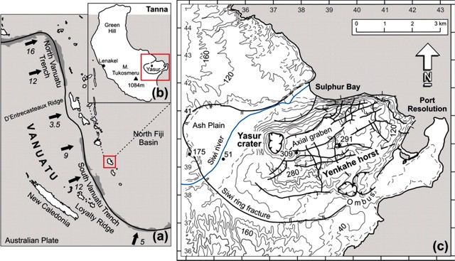 |
Figure 42. (a) Map showing the Vanuatu arc in the SW Pacific, the position of the 6-7 km deep Vanuatu trench, convergence rates (indicated by arrows in cm/yr), and the location of Tanna volcanic island, which rises from a 1-km-deep plateau (redrawn from Pelletier and others, 1998 and Calmant and others, 2003). (b) Schematic map of Tanna island with the locations of the main volcanic centers (redrawn from Carney and MacFarlane, 1979). In its long dimension (N-S), Tanna island stretches ~40 km; its width is ~19 km. (c) Map of southeastern Tanna showing the Yasur crater and Yenkahe horst, bounded by the Siwi ring fracture (redrawn from Nairn and others, 1988 and Allen, 2005). From Métrich and others (2011). |
An assessment conducted by the Vanuatu Geohazards Observatory (VGO) during 30 May-3 June 2011 found Yasur's crater in a state of high activity with strong explosions and bomb emissions from all of the three active vents. Fresh volcanic bombs fell around the crater rim, and some reached ~500 m S to the parking area, landing there about once per minute. Residents heard and viewed explosions from their villages.
Observations and assessments made by VGO during 11-12 June 2011 indicated a decrease in eruptive vigor and a return to more typical conditions. Explosions became both slightly weaker and less frequent. Constant Strombolian activity with occasional ejections of lava bombs still occured around the volcano.
On 7-8 July 2011 the VGO reported that Yasur volcano was at a high level of activity with strong degassing and ash emissions from all three active vents. The ash falls were mostly over the W part of the island. Fresh volcanic bombs had fallen around the crater rim. Some explosions could be heard and viewed from the villages, a pattern locals had noticed since the beginning of the year.
Hazard terminology and levels. The operative hazards scale for Yasur spans from 0 to 4, with larger values indicating greater hazards. It is called the VVAL (Vanuatu Volcano Alert Level).
Level 2 is defined as "Moderate eruptions, danger close to the volcano vent, within parts of Volcanic Hazards Map Red Zone" (see map in BGVN 35:04).
Level 3 is defined as "Large eruption, danger in specific areas within parts of Volcanic Hazards Map Red and Yellow Zones."
In the early phases of the upsurge in vigor, the VVAL for Yasur remained at Level 2 with the note that the risk area for volcanic projectiles remained in areas near the volcano crater and vicinity.
Associated with the assessed late-May to early June behavior, the VVAL stepped up to Level 3. A zone surrounding the summit became strictly prohibited (see visitor's map, BGVN 35:04).
Associated with the 11-12 June 2011 observations of decreasing vigor, the VVAL dropped to Level 2.
Background. Métrich and others (2011) point out that Siwi caldera is a volcanic complex containing both persistent eruptive activity of basaltic-trachyandesite composition (Yasur volcano) and rapid block resurgence (Yenkahe horst). They note that available data suggested that Yasur volcano releases, on average, over 134 x 103 tons/day of H2O and 680 tons/day of SO2. Measurements also indicated other gas fluxes: 840 tons/day of CO2, 165 tons/day of HCl, and 23 tons/day of HF.
References. Allen, S.R., 2005, Complex spatter- and pumice-rich pyroclastic deposits from an andesitic caldera forming eruption: The Siwi pyroclastic sequence, Tanna, Vanuatu, Bulletin of Volcanology, v. 67, pp. 27-41.
Calmant, S., Pelletier, B., Lebellegard, P., Bevis, M., Taylor, F.W., and Phillips, D.A., 2003, New insights on the tectonics along the New Hebrides subduction zone based on GPS results, Journal of Geophysical Research, v. 108, no. B6, pp. 2319-2339.
Carnay, JN., and MacFarlane, A, 1979, Geology of Tanna, Aneityum, Futuna and Aniva, New Hebrides Geological Survey Report 1979, pp. 5-29.
Métrich, N., Allard, P., Aiuppa, A., Bani, P., Bertagnini, A., Shinohara, H., Parello, F., Di Muro, A., Garaebiti, E., Belhadj, O., and Massare, D., 2011, Magma and Volatile Supply to Post-collapse Volcanism and Block Resurgence in Siwi Caldera (Tanna Island, Vanuatu Arc), Journal of Petrology, v. 52, no. 6, pp. 1077-1105; DOI: 10.1093/petrology/egr019.
Nairn, I.A., Scott, B.J., and Giggenbach, W.F., Yasur volcanic investigations, Vanuatu September 1988, New Zealand Geological Survey Report 1988, pp.1-74.
Pelletier, B., Calmant, S., and Pillet, R., 1998, Current tectonic of the Tonga-New Hebrides region, Earth and Planetary Science Letters, v. 164, pp. 263-276.
Geological Summary. Yasur has exhibited essentially continuous Strombolian and Vulcanian activity at least since Captain Cook observed ash eruptions in 1774. This style of activity may have continued for the past 800 years. Located at the SE tip of Tanna Island in Vanuatu, this pyroclastic cone has a nearly circular, 400-m-wide summit crater. The active cone is largely contained within the small Yenkahe caldera, and is the youngest of a group of Holocene volcanic centers constructed over the down-dropped NE flank of the Pleistocene Tukosmeru volcano. The Yenkahe horst is located within the Siwi ring fracture, a 4-km-wide open feature associated with eruption of the andesitic Siwi pyroclastic sequence. Active tectonism along the Yenkahe horst accompanying eruptions has raised Port Resolution harbor more than 20 m during the past century.
Information Contacts: Vanuatu Geohazards Observatory, Department of Geology, Mines and Water Resources of Vanuatu (URL: http://www.geohazards.gov.vu); NASA Earth Observatory (URL: http://earthobservatory.nasa.gov/); MODIS/MODVOLC Thermal Alerts System, Hawai'i Institute of Geophysics and Planetology (HIGP), School of Ocean and Earth Science and Technology (SOEST), Univ. of Hawai'i, 2525 Correa Road, Honolulu, HI 96822, USA (URL: http://modis.higp.hawaii.edu/); Wellington Volcanic Ash Advisory Centre (VAAC), Meteorological Service of New Zealand Ltd (MetService), PO Box 722, Wellington, New Zealand (URL: http://www.metservice.com/vaac/, http://vaac.metservice.com/).