Report on Erta Ale (Ethiopia) — June 2011
Bulletin of the Global Volcanism Network, vol. 36, no. 6 (June 2011)
Managing Editor: Richard Wunderman.
Erta Ale (Ethiopia) Observers watch dynamic lava lake during November 2010
Please cite this report as:
Global Volcanism Program, 2011. Report on Erta Ale (Ethiopia) (Wunderman, R., ed.). Bulletin of the Global Volcanism Network, 36:6. Smithsonian Institution. https://doi.org/10.5479/si.GVP.BGVN201106-221080
Erta Ale
Ethiopia
13.601°N, 40.666°E; summit elev. 585 m
All times are local (unless otherwise noted)
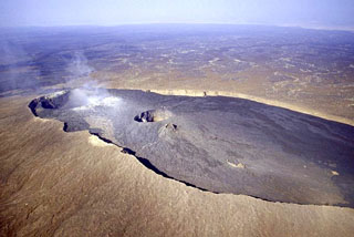
Erta Ale contains two lava lakes within its caldera. During the last three years, several expeditions have visited the volcano to examine changes (BGVN 33:06, 34:07, and 35:01). This report synthesizes the reports of two teams that visited Erta Ale during November 2010. Both teams noted that the lava lake within the southern crater has risen, nearly filling the entire crater and overflowing onto the caldera floor.
Southern Crater activity. Afar Rift Consortium (ARC) scientists visited Erta Ale during 21-23 November 2010 (figures 28 and 29). Tom Pfeiffer (Volcano Discovery) and Micheal Dalton-Smith visited Erta Ale during 25-28 November 2010. The lava lake had risen above previously formed terraces (see BGVN 35:01 for information on terraces). Both teams noted that the lava lake had risen ~40 m, nearly filling the S crater and breaching its W rim, spilling lava flows onto the larger caldera floor. The still-hot overflows traveled distances of 50-100 m on the caldera floor, and one recent long flow (estimated to be from November 24th given its temperature) had almost reached the W caldera walls.
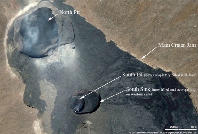 |
Figure 28. Satellite image of the Erte Ale caldera showing the two crater pits. Courtesy of Google Earth, with labels by Afar Rift Consortium in reference to their 21-23 November 2010 visit (Field and Keir, 2010). |
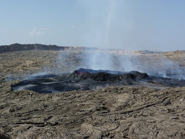 |
Figure 29. Photograph of the Erte Ale showing the lava lake with an elevated rim, taken 22 November 2010. Person in bottom left of photo for scale. Photo by L. Field (Afar Rift Consortium). Taken from Field and Keir (2010). |
The ARC team noted Strombolian activity from the lava lake in the southern pit crater (figure 30).Throughout their visit, the ARC team saw extensive amounts of Pele's Hair and clouds rich in hydrogen-sulfide gas. Fountaining was reported by Pfeiffer to reach heights of 30-70 m. Degassing fountains kept the whole lava-lake surface violently boiling for a large portion of the latter team's visit.
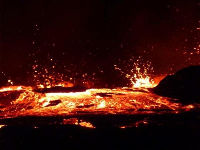 |
Figure 30. Photograph of the first lava to breach the rim of Erta Ale's S crater and then to enter the main caldera. Taken 21 November 2010 by L. Field (from Field and Keir, 2010). |
The still-active lake was circular, ~40 m in diameter (about half to two-thirds its size in 2008 and 2009). The lava lake was reported to be encompassed by a bounding ring of chilled material that was ~ 4 m high on the S side. The morphology of the ring wall constantly changed as more lava overflowed, with parts collapsing and rebuilding.
From the night of the 22 November 2010 until the ARC team left on 23 November, the team observed a periodic rise and decline of the lava lake level.
According to Pfeiffer the lava level rose and fell by about 2-4 m about every 30 minutes. During the 25-28 November observations intense eruptive phases were observed. Lava overflowed about 12 times and fed new flows that topped older flows. During 25-28 November, the overall average level of the lake's surface rose an estimated 3-5 m.
Northern Crater activity. The ARC noted that during 21-23 November the northern crater pit was relatively quiet. They observed a small amount of incandescence during the night of 21 November (figure 31). During the day, they noted a new cone about 1 m high and lava flows of limited extent.
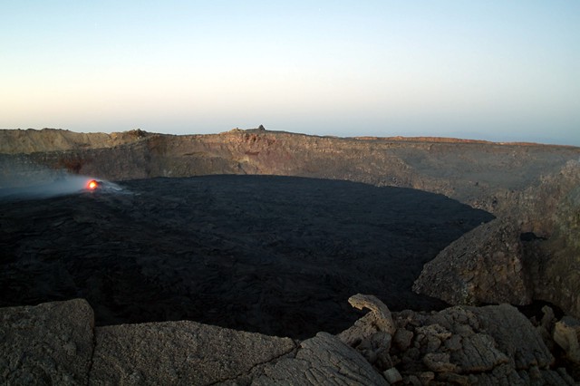 |
Figure 31. Photograph taken in January 2011 of an Erta Ale hornito with an incandescent vent in the N crater. Photo taken by M. Fulle. |
According to the Volcano Discovery team, the deeper N crater had not changed much since their previous visit in February 2008 (BGVN 33:06). During their 2010 visit they saw a 7-10 m high hornito, in the N crater's center, with a glowing vent that sometimes spattered lava. According to Dalton-Smith, flaming gas was seen during the day and on 25 November, an extremely bright glow was seen at night. Upon the team's arrival at the volcano, a large fresh flow had recently surged from the hornito and covered most of the N crater floor.
Location and tectonics. Erta Ale is located in the Afar rift, a region that shows signs of undergoing a continent to ocean transition. The Afar rift is located between the Nubian and the Somalian plates. There is reason to believe that the mantle below the Afar rift region has an above average temperature (Bastow and Keir, 2011). The Afar Rift Consortium also noted that recent fissure eruptions occurred on Erta Ale's N flank.
References. Field, L, and Keir, D. 2010, Observations from the Erta Ale eruption 21st Nov-23rd Nov 2010. Afar Rift Consortium (ARC) (URL: http://www.see.leeds.ac.uk/afar/new-afar/home-page-assets/Observations_from_Erta_Ale.pdf). Additional information about the work of the ARC can be found at URL: http://www.see.leeds.ac.uk/afar/.
Fulle, M, 2011, Stromboli Online (URL: http://www.swisseduc.ch/stromboli/perm/erta/lake-2011-en.html).
Bastow, ID, and Keir, D, 2011, The protracted development of the continent-ocean transition in Afar, Letters, Nature Geoscience, DOI: 10.1038/NGEO1095 published online on March 11, 2011.
Keir, D, Pagli, C, Bastow, ID, Ayele, A., 2011, The magma-assisted removal of Arabia in Afar: Evidence from dike injection in the Ethiopian rift captured using InSAR and seismicity, Tectonics, v. 30, TC2008, DOI: 10.1029/2010TC002785, published 22 March 2011.
Geological Summary. The Erta Ale basaltic shield volcano in Ethiopia has a 50-km-wide edifice that rises more than 600 m from below sea level in the Danakil depression. The volcano includes a 0.7 x 1.6 km summit crater hosting steep-sided pit craters. Another larger 1.8 x 3.1 km wide depression elongated parallel to the trend of the Erta Ale range is located SE of the summit and is bounded by curvilinear fault scarps on the SE side. Basaltic lava flows from these fissures have poured into the caldera and locally overflowed its rim. The summit caldera usually also holds at least one long-term lava lake that has been active since at least 1967, and possibly since 1906. Recent fissure eruptions have occurred on the N flank.
Information Contacts: Afar Rift Consortium (URL: http://www.see.leeds.ac.uk/afar/); Tom Pfeiffer, Volcano Discovery (URL: http://www.VolcanoDiscovery.com/); Michael-Dalton-Smith, Digital Crossing Productions (URL: http://www.digitalcrossing.ca/); Marco Fulle, Osservatorio Astronomico, Trieste, Italy (URL: http://www.ts.astro.it/) and atStromboli Online (URL: http://www.swisseduc.ch/stromboli/perm/erta/lake-2011-en.html).