Report on Batur (Indonesia) — June 2011
Bulletin of the Global Volcanism Network, vol. 36, no. 6 (June 2011)
Managing Editor: Richard Wunderman.
Batur (Indonesia) Thousands of dead fish floating in caldera lake during June 2011
Please cite this report as:
Global Volcanism Program, 2011. Report on Batur (Indonesia) (Wunderman, R., ed.). Bulletin of the Global Volcanism Network, 36:6. Smithsonian Institution. https://doi.org/10.5479/si.GVP.BGVN201106-264010
Batur
Indonesia
8.2403°S, 115.3775°E; summit elev. 1711 m
All times are local (unless otherwise noted)
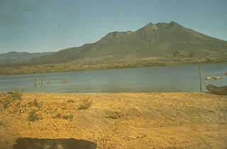
Batur stratovolcano sits at the E end of the island of Bali amid nested calderas (figure 4) and rises 686 m above the surface of an intra-caldera lake of the same name (Sutawidjaja, 2009). The entire complex remained non-eruptive through at least mid-2011 as it has for at least a decade (since a moderate eruption in 1974 and a series of smaller eruptions in the 1990s ceasing in about 2000). Local authorities reported that, following some variable seismicity during 2009-2010, starting 19 June 2011 residents smelled sulfurous gas and saw many dead fish floating on the lake's surface. The kill took place in the volcano's caldera lake but in the absence of visible eruptive activity and without anomalous geophysical perturbations.
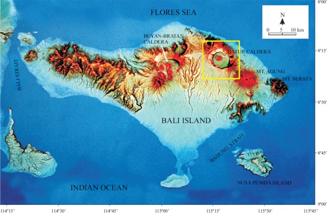 |
Figure 4. Physiographic map of the island of Bali highlighting Batur caldera. The topographic high in the N-central caldera is Batur stratovolcano (summit elevation, 1,717 m). The lake (not delineated) lies along the caldera's SE side. Taken from Sutawidjaja (2009). |
Our previous report on Batur (BGVN 34:11) had noted increased seismicity from September to 7 November 2009. Since that report, the Center of Volcanology and Geological Hazard Mitigation (CVGHM) has reported that seismicity from Batur decreased from 1 June to 17 November 2010 and fumarolic plumes rose from the crater. On 19 November the Alert level was lowered to Normal, or 1.
Investigation of thousands of dead fish. CVGHM scientists visited Lake Batur (figure 5) to learn more about the incident. They learned that residents of lakeside villages first observed lake water discoloration and acrid (like sulfur) odors on the morning of 19 June 2011. A greenish-white discoloration first emerged in spots, but these spots soon connected and spread. The residents had seen a slick on the water surface spread from the E-central lake shore towards the S (from Toya Bungkah to Buahan, figure 6). In conjunction with these changes in color, thousands of dead fish were found at the surface of the lake (figure 7).
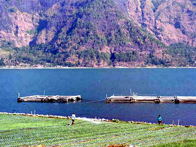 |
Figure 5. Photo of Lake Batur with two farmers for scale. The tops of fish cages (kerambah) can be seen in the lake water. Note steep caldera wall in background. Photo taken from allvoices.com. (Photographer unknown and other details undisclosed.) |
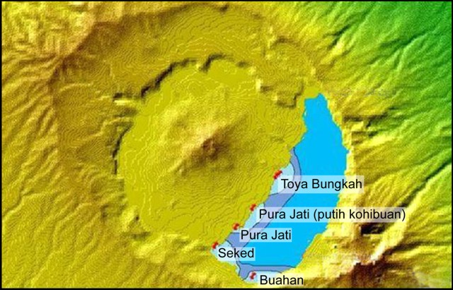 |
Figure 6. Map showing location of Lake Batur, with the locations of the greenish-white water seen near the coast (shaded). The lake is 7.7 km in the long dimension and has a surface area of 16 km2. Courtesy of CVGHM. |
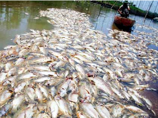 |
Figure 7. Photo of dead fish floating on the surface of Lake Batur associated with the fish kill of 2011. Thousands of fish died, many near the village of Toya Bungkah. Undated photo taken from indosurflife.com. |
The translated report contained this important passage. "According to information from a resident (Made Yuni, age 59), the change in color of the lake water, consisting of patches of whitish green, is a yearly event, although [typically] small in scale and not causing the death of fish. The change in color of the lake water occurs during the change of seasons (i.e. the transition), between the wet and dry parts of the year when there is a stiff wind from the S. The incident of the lake water changing color and the death of the fish on 19 June 2011 occurred about two weeks into the dry season. The death of fish in Batur on the present scale happened before, in 1995."
Scientists conducted an examination during 21-22 June 2011. They also had pre-event temperature and pH for multiple sites on the lake going back at least several months. At the time of the visit, all residual odors had dispersed. Results of ambient gas measurements showed no traces of anomalous carbon monoxide, carbon dioxide, methane, or hydrogen sulfide. The lake temperature was found to be 15°C, which is considered normal. pH levels in the lake were found to be constant with other measurements taken in normal times as well. No increase in volcanic earthquakes were reported before or after the fish kill (the pattern of earthquakes was constant at typical background, 1 event/day). The colors seen were attributed to both warm water welling up (springs at Toya Bungkah) but also at places where such springs are absent.
On 20 June the water by the village of Seked returned to its normal color. Late in 21 June the water by the other villages involved returned to its normal color. Scientists found neither dead weeds or algae nor gas bubbles associated with the fish kill.
Scientists from CVGHM found no evidence to conclude the fish kill was volcanically triggered nor did they mention it portending eruptive activity. Rather, the scientists noted the comparatively high diurnal-temperature difference during the onset of the dry season. As a result of these temperature differences, the lake water developed currents, which carried mud from the lake bottom to the surface. This was thought to correspond to the observed odors ('muddy smells') and color changes on the lake surface. In a broad sense, the currents and mud were thought to upset the lake's ecological balance in a manner toxic to the fish.
Residents were advised to not consume dead fish from the incident, but fish that had survived were still considered fit for human consumption. Many inhabitants around Lake Batur are fisherman by trade and it is estimated that the fish kill resulted in losses up to billions of Rupiah (1 billion Rupiah currently equivalent to ~120,000 US Dollars). The water of Lake Batur is also irrigated into surrounding farms. There is no official documentation on whether or not the recent events at Lake Batur have affected the neighboring agriculture.
Reference. Sutawidjaja, I.S., 2009, Ignimbrite Analyses of Batur Caldera, Bali, based on 14C dating, Jurnal Geologi Indonesia, Vol. 4 No. 3, September 2009: 189-202 [http://www.bgl.esdm.go.id/dmdocuments/jurnal20090304.pdf].
Geological Summary. The historically active Batur is located at the center of two concentric calderas NW of Agung volcano. The outer 10 x 13.5 km caldera was formed during eruption of the Bali (or Ubud) Ignimbrite about 29,300 years ago and now contains a caldera lake on its SE side, opposite the Gunung Abang cone, the topographic high of the complex. The inner 6.4 x 9.4 km caldera was formed about 20,150 years ago during eruption of the Gunungkawi Ignimbrite. The SE wall of the inner caldera lies beneath Lake Batur; Batur cone has been constructed within the inner caldera to a height above the outer caldera rim. The Batur stratovolcano has produced vents over much of the inner caldera, but a NE-SW fissure system has localized the Batur I, II, and III craters along the summit ridge. Recorded eruptions have been characterized by mild-to-moderate explosive activity sometimes accompanied by lava emission. Basaltic lava flows from both summit and flank vents have reached the caldera floor and the shores of Lake Batur in historical time.
Information Contacts: Center of Volcanology and Geological Hazard Mitigation (CVGHM), Jalan Diponegoro 57, Bandung 40122, Indonesia (URL: http://www.vsi.esdm.go.id/); Bali Discovery Tours, Komplek Pertokoan Sanur Raya No. 27 Jl. By Pass Ngurah Rai,Sanur, Bali, Indonesia (URL: http://www.balidiscovery.com)