Report on Lokon-Empung (Indonesia) — June 2011
Bulletin of the Global Volcanism Network, vol. 36, no. 6 (June 2011)
Managing Editor: Richard Wunderman.
Lokon-Empung (Indonesia) July 2011 ash plumes spur 4,000 to 6,000 to evacuate
Please cite this report as:
Global Volcanism Program, 2011. Report on Lokon-Empung (Indonesia) (Wunderman, R., ed.). Bulletin of the Global Volcanism Network, 36:6. Smithsonian Institution. https://doi.org/10.5479/si.GVP.BGVN201106-266100
Lokon-Empung
Indonesia
1.3644°N, 124.7992°E; summit elev. 1580 m
All times are local (unless otherwise noted)
This report discusses Lokon-Empung during February to mid-July 2011. There were occasional modest ash-bearing eruptions and elevated seismicity through June. Stronger ash plumes during July spurred evacuations. Our previous report noted unrest during 2007 through March 2008 (BGVN 33:02). According to the Center of Volcanology and Geological Hazard Mitigation (CVGHM), since February 2008 through the reporting period, seismic activity was characterized by daily volcanic earthquakes and occasional phreatic eruptions when rainfall was high.
According to CVGHM and news articles, on 22 February 2011, a phreatic eruption discharged from Tompaluan crater (figures 4 and 5). The eruption was possibly triggered by high rainfall. It produced an ash plume that rose 400 m above the crater rim and drifted SE.
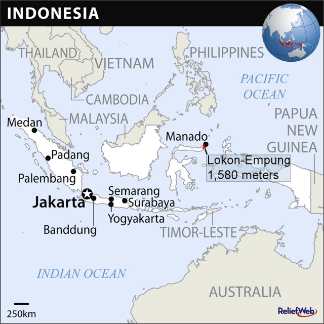 |
Figure 4. An index map and globe showing Indonesia and some neighboring countries. Note the location of Sulawesi island (Indonesia) and Lokon-Empung volcano. Courtesy of Relief Web. |
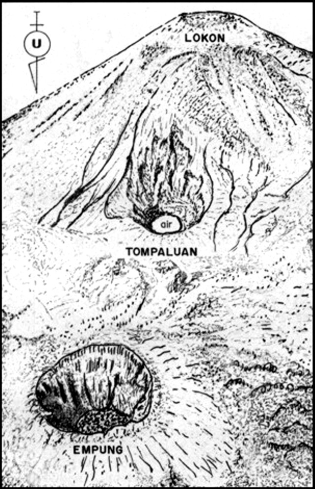 |
Figure 5. A 1982 sketch map looking from the N at the three main craters at Lokon-Empung. Note the middle crater (Tompaluan) is the one from which the current eruption is venting. The word "air" in the bottom of the crater means water in Indonesian; it refers to the shallow lake that periodically appears on the crater floor. Courtesy of the Volcanological Survey of Indonesia. |
CVGHM reported that, during 1-25 June 2011, white plumes rose 50-200 m above Tompaluan crater. On 26 June, a phreatic eruption ejected material that both fell around the crater and produced a gray plume that rose 400 m above the crater rim and drifted N. Seismicity increased the next day and white plumes rose 50-200 m above the crater. The Alert Level was raised to 3; prohibiting visitors and residents entering within a 3-km radius of the crater.
According to CVGHM, during 28 June-9 July 2011 white plumes rose 50-400 m above Tompaluan crater and gray ash plumes rose 100-500 m above the crater. An ash eruption on 10 July 2011 produced white-to-gray plumes that rose 200-400 m above the crater. Fluctuations in the sulfur dioxide gas emission rate were noted during 30 June-10 July. Based on gas flux, seismicity, visual observations, and hazard assessment, CVGHM raised the Alert Level to 4. On 11 July, the Darwin Volcanic Ash Advisory Centre (VAAC) reported that ash plumes detected in satellite imagery rose to an altitude of 1.5 km and drifted NW. According to news articles, close to 1,000 residents were evacuated from the area during 11-12 July 2011.
HOPE Worldwide, a non-profit non-governmental organization, issued a report on 15 July 2011 stating that at 2331 on the 14 July Lokon erupted and sent lava, ash, and gases 1.5 km over the summit. "No death is yet to be reported due to the eruption, but there are 4,412 persons displaced in the Tomohon city, just south of Manado city, the capital of North Sulawesi Province." Displaced residents went to schools and a city park.
Figures 6-8 show photos of molten material and eruptions taken from various perspectives on 14 and 17 July. The photo shown as figure 8 accompanied another panoramic shot with the eruption.
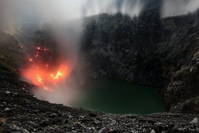 |
Figure 6. Lokon volcano photographed at night on 14 July 2011. Tompaluan crater contained a small lake and molten material appeared on the far crater side of the crater. Courtesy of the blog named 11reviews.blogspot.com. |
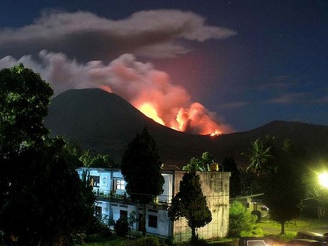 |
Figure 7. Lokon erupting late on 17 July 2011, spewing rocks, lava and ash hundreds of meters into the air. Courtesy of AFP. |
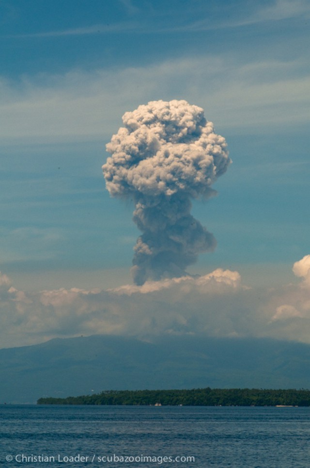 |
Figure 8. An eruption at Lokon seen across the water from distance (taken at 1100 on 17 July 2011). This photo was posted on the Flickr website. Copyrighted photo by Christian Loader (scubazooimages.com). |
A video posted on The Guardian website (on 15 July) shows people dispensing face masks to residents as ash from Lokon falls. The original video apparently came from Associated Press (2011; see Reference list).
According to the news agency AFP, a small eruption—the largest since late June—lit up the night sky on 17 July, sending a large ash plume '3.5 km up into the sky.' A nearby airport was placed on alert, but as of 18 July flights were not affected. The article said that, since this latest (17 July) eruption, more than 5,200 residents had been evacuated. Other reports noted the number of displaced residents in the range 4,000-6,000.
Reference. Associated Press, 2011, Indonesian volcano erupts, Thousands of residents evacuated from slopes of Mount Lokon in Sulawesi province (AP photo used in 15 July 2011 article on The Guardian.co.uk website) (URL: http://www.guardian.co.uk/world/2011/jul/15/indonesian-volcano-erupts).
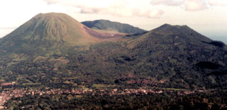
Geological Summary. The Lokong-Empung volcanic complex, rising above the plain of Tondano in North Sulawesi, includes four peaks and an active crater. Lokon, the highest peak, has a flat craterless top. The morphologically younger Empung cone 2 km NE has a 400-m-wide, 150-m-deep crater that erupted last in the 18th century. A ridge extending 3 km WNW from Lokon includes the Tatawiran and Tetempangan peaks. All eruptions since 1829 have originated from Tompaluan, a 150 x 250 m crater in the saddle between Lokon and Empung. These eruptions have primarily produced small-to-moderate ash plumes that sometimes damaged croplands and houses, but lava-dome growth and pyroclastic flows have also occurred.
Information Contacts: Center of Volcanology and Geological Hazard Mitigation (CVGHM), Jalan Diponegoro 57, Bandung 40122, Indonesia (URL: http://www.vsi.esdm.go.id/); Darwin Volcanic Ash Advisory Centre (VAAC), Bureau of Meteorology, Northern Territory Regional Office, PO Box 40050, Casuarina, NT 0811, Australia (URL: http://www.bom.gov.au/info/vaac/); HOPE Worldwide, 353 W. Lancaster Avenue, Suite 200, Wayne, PA, 19087 USA URL: http://www.hopeww.org); Associated Press at CBS news (URL: http://www.cbsnews.com); Tempo (URL: http://www.tempointeraktif.com/); Media Indonesia.com (URL: http://www.mediaindonesia.com/); Agence France Press (AFP) (URL: http://www.afp.com/afpcom/en/); Blogspot.com (URL: http://11reviews.blogspot.com)