Report on Rabaul (Papua New Guinea) — July 2011

Bulletin of the Global Volcanism Network, vol. 36, no. 7 (July 2011)
Managing Editor: Richard Wunderman.
Rabaul (Papua New Guinea) Two small eruptions since one in July 2010
Please cite this report as:
Global Volcanism Program, 2011. Report on Rabaul (Papua New Guinea) (Wunderman, R., ed.). Bulletin of the Global Volcanism Network, 36:7. Smithsonian Institution. https://doi.org/10.5479/si.GVP.BGVN201107-252140
Rabaul
Papua New Guinea
4.2459°S, 152.1937°E; summit elev. 688 m
All times are local (unless otherwise noted)
A significant volume of ash from the Tavurvur cone of Rabaul volcano fell in the surrounding region during an eruption on 23-24 July 2010 (BGVN 35:09). Moderate SE winds and moving vehicles raised dust and presented difficult conditions for residents. Similar conditions were reported by the Rabaul Volcano Observatory (RVO, a facility that sits 6.75 km NW of Tavurvur) through the rest of 2010 and early into 2011. This report discusses behavior as late as mid-2011. This report also draws attention to a comprehensive overview of the Rabaul volcano by Johnson and others (2010), the result of the Rabaul Volcano Workshop held in the town of Rabaul (about 6 km NW of Tavurvur), Papua New Guinea during 17-18 November 2009. Several of the maps and figures from that report appear below.
RVO reported that post-eruption processing of Global Positioning System (GPS) data showed slight deflation after the eruption of 23-25 July 2010. Sulfur dioxide (SO2) gas measurements on 28 July were low. RVO opined that the lack of seismicity suggested Tavurvur would remain quiet; however, changes in the status of the volcano can happen very rapidly as was the case on 23 July. For the period from 26 July to 12 August 2010 no ash emissions occurred from Tavurvur cone. Only very small volumes of white vapor were released. No audible noises were reported and no incandescence was observed. In addition, seismicity was very low.
GPS measurements on Matupit Island continued to show inflation; long-term information indicated further increase in the rate of uplift from mid-February 2011 onwards.
RVO had noted a swarm of high frequency volcano-tectonic earthquakes on 28 February 2011 in the caldera's NE sector. This swarm followed the occurrence of both small, discrete, high-frequency earthquakes and an emergence of low-frequency earthquakes. Previous observations during the past 16 years suggest strong connections between such NE-sector earthquakes and either renewed eruption or increased activity from Tavurvur. However, in this case RVO did not report increased activity following the 28 February seismic swarm.
RVO reported that Tavurvur remained quiet throughout the month of March 2011. Activity consisted mainly of very small volumes of thin white vapor, which became denser during rain and cool conditions. No audible noises were heard and no glow was observed at night. That said, based on analyses of satellite imagery, the Darwin VAAC reported that on 29 March an ash plume rose to an altitude of 3 km and drifted over 53 km NW.
During an on-site inspection in March 2011 steady dull glow was observed in three small vents on the floor of the crater, indicating the presence of magma near the surface. Incandescence on the crater floor was still present when the volcano was observed during another on-site inspection in April 2011, however the vent opening had become enlarged due to collapse of material surrounding the earlier vents.
During April and most of July 2011, RVO reported variable amounts of white vapor emissions, occasionally tinted blue, and no audible noises. About twelve earthquakes were recorded in July; the most notable events occurred on 12, 15, 19, 20, and 27 July. A new eruption characterized by emergent low-frequency tremors and slowly rising gray ash plumes occurred on 29 July 2011 at 1332. A single explosion occurred on 30 July at 0106 which probably produced light ashfall to the NW. The explosion produced a short explosion noise. A brief period of harmonic volcanic tremors was recorded between 0740 and 0758 hours on 1 August 2011, presumably caused by forceful vent degassing. There was no short-term anomalous seismicity prior to the start of the eruption.
GPS measurements on Matupit Island continued to show long-term inflation; about 10-11 cm of uplift was recorded since August 2010. There was a slight drop in the rate of the uplift in early-to mid-July 2011. The drop did not affect the long-term trend of uplift significantly.
RVO reported that white vapor plumes rose from the Tavurvur cone during 1-3 August 2011. An explosion on 3 August produced a gray ash plume that rose 1 km above the crater and drifted NNW. Sustained emissions of pale-gray ash continued for about an hour afterwards. In addition, ash deposited at the former airport was re-suspended and blown NW into the E part of Rabaul town (3-5 km NW) and towards Namanula hill (3 km W). Seismicity was very low, although two periods of harmonic tremor on 2 August and the explosion and ash emissions on 3 August were detected.
During 4-5 August 2011 gray ash emissions periodically continued, punctuated by a few large and notable explosions. Ash plumes from the explosions rose 1 km above the crater and drifted N and NW producing fine ashfall in the E part of Rabaul town, Namanula Hill, and further downwind towards Tavui Point. Moderate seismicity consisting of low-frequency earthquakes, explosions, and volcanic tremors with variable durations was detected. During 5-9 August activity increased, characterized by an increased frequency and duration of ash emissions and more explosions. About 34 explosions were recorded between 5 and 8 August. Ash-rich clouds that rose 1.5 km above the crater drifted NW, causing ashfall in most parts of Rabaul town and in areas between Toliap and Nonga (10 km NW).
With the resumption of ash emissions, the trend of uplift during the past year, discrete volcano-tectonic earthquakes detected during the past two months, and the magnitude of the earthquake swarm that occurred in the caldera's NE sector in late February 2011, RVO warned that possible sporadic ashfall may occur in the future.
Report of the 2009 Rabaul workshop. The Rabaul Volcano Workshop of 2009 was held to review, synthesize, and assess geoscientific information on the volcanoes of the NE Gazelle Peninsula and identify needed instrumental monitoring and scientific research directions. Several figures from the workshop report (Johnson and others, 2010) give current ideas about Rabaul and vicinity. This includes an array of volcanoes at the N end of the Gazelle Volcanic Zone (figure 51), New Britain volcanism (figure 52), the Nengmutka-to-Tavui volcanic centers (figure 53), and the spatial distribution of earthquakes (figure 54). In addition, two kinds of cross-sectional models of Rabaul are included (figures 55 and 56).
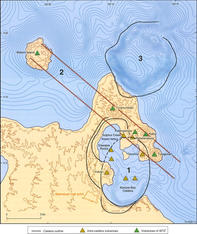 |
Figure 51. Map of the N end of the Gazelle volcanic zone with the location of the Rabaul caldera and the active cones of Tavurvur and Vulcan. Shown schematically are (1) the nested calderas of Rabaul volcano (called the Blanche Bay Caldera Complex), (2) volcanoes of the Watom-to-Turagunan Zone (WTZ), and (3) Tavui caldera (50 m isobaths in the ocean). From Johnson and others (2010-their figure 13, page 17). |
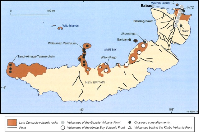 |
Figure 52. Volcanic centers and faults of New Britain. Dashed line represents the S extension of the Gazelle volcanic front to the Wide Bay fault. Based on the geological map compiled by D'Addario and others (1976). From Johnson and others (2010-their figure 19, page 27). |
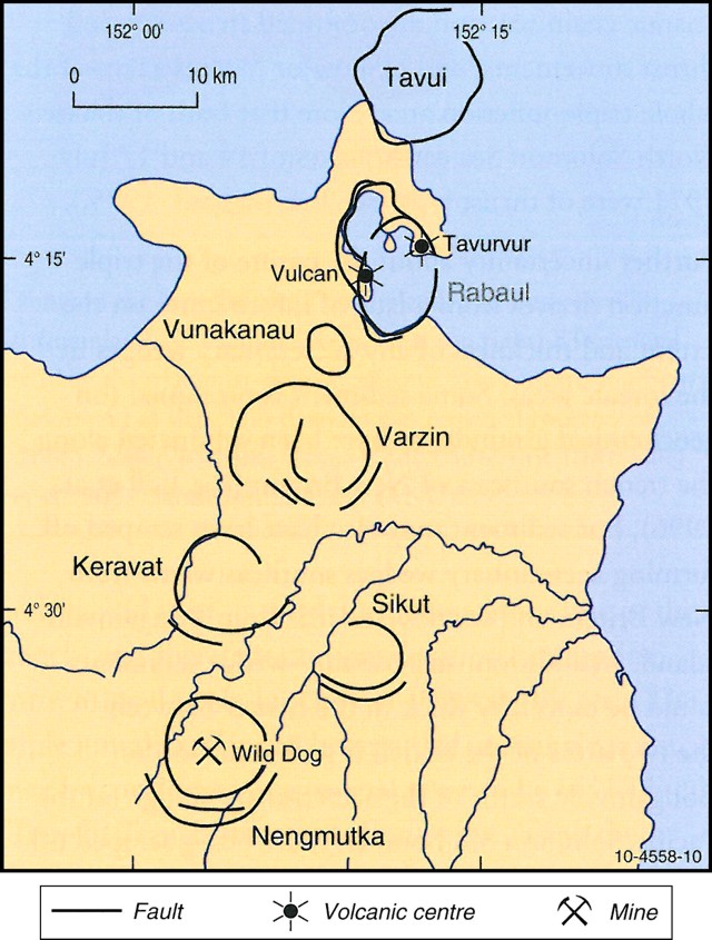 |
Figure 53. Collapse structures comprising the Nengmutka-to-Tavui volcanic centers in the Gazelle volcanic zone. From Johnson and others (2010-their figure 10, page 12). |
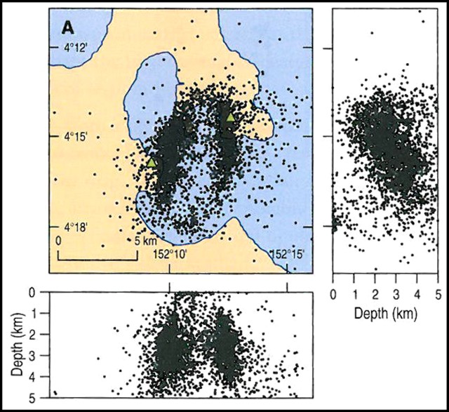 |
Figure 54. Relocated hypocenters for Rabaul from a study conducted during August 1997 to January 1998, a map in a horizontal view and two cross-sections, one N-S (right) and one W-E (bottom). Hypocenters form an elongate ring-fault pattern; the cross-sections suggest that the ring faults are straight sided in the N-looking (lower) figure and more complex in the W-looking figure (at right). From Johnson and others (2010-their figure 32A, page 44). |
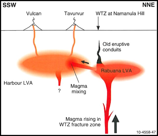 |
Figure 55. An interpretive cross-section depicting magma trelationships for Rabaul (location of the roughly N-S line shown in the next figure). The model given involves mixing between mafic magma, which is being injected (inclined arrow) from the Rabuana LVA (seismic low-velocity anomaly) into the dacite magma of the Harbour LVA. Gradational boundaries signify crystal/melt mushes of old magma and the absence of precise boundaries for the two magma reservoirs. Vulcan and Tavurvur cones are projected onto the plane of the cross section. The exact position of the magma-feeder zone beneath the Rabuana LVA is unknown and is here drawn rather arbitrarily just to the NE of the WTZ itself. From Johnson and others (2010-their figure 47, page 68). |
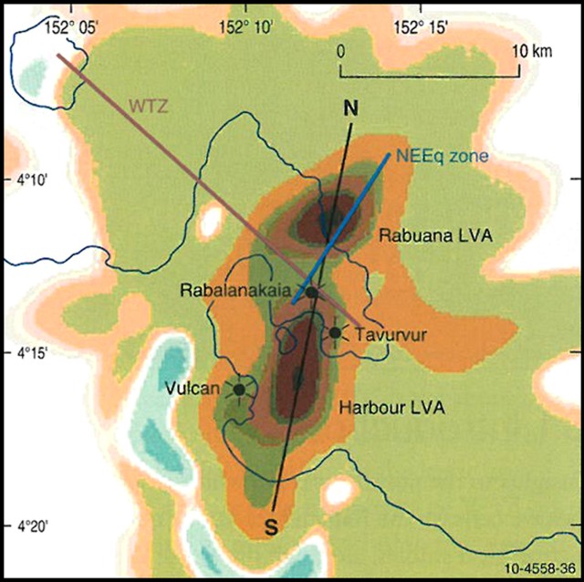 |
Figure 56. A Rabaul map based on seismic profiling. The map shows P-wave velocity perturbation for a 5-km-deep, horizontal slice. It shows the so-called Harbor LVA (seismic low-velocity anomaly) and the Rabuana LVA. Rabalanakaia (a cone of Rabaul volcano) lies between the two anomalies, and the Harbour LVA lies between Tavurvur and Vulcan cones. The WTZ (Watom-to-Turagunan Zone-see figure 51) and North East Earthquakes (NEEq) fault zone intersect near Rabalanakaia. The line labeled N-S signifies the cross-section in the previous figure. From Johnson and others (2010-their figure 36, page 49). |
According to the workshop report, over the last 15 years Tavurvur has been erupting with a Volcanic Explosivity Index (VEI) of 3 to 4. The Rabaul caldera has produced a variety of products due to magma mixing.
The report noted that Tavurvur's eruption style differs from the other volcanoes in the caldera. It has two different styles of eruptions: phreatomagmatic and Vulcanian-Strombolian. Tavurvur's eruptions last significantly longer. These facts, in addition to Tavurvur's emission of sulfur dioxide (SO2), lead to the conclusion that Tavurvur is part of an active geothermal system. This geothermal system overlies a magma chamber that is in contact with basalt (leading to magma mixing). That magmatic system is actively degassing.
References. D'Addario, G.W., Dow, D.B., and Swoboda, R., 1976, Geology of Papua New Guinea, Bureau of Mineral Resources, Canberra, Australia.
Johnson, R.W., Itikarai, I., Patia, H., and McKee, C.O., 2010. Volcanic systems of the Northeastern Gazalle Peninsula, Papua New Guinea: Synopsis, evaluation, and a model for Rabaul volcano; Rabaul Volcano Workshop Report, Papua New Guinea Dept.of Mineral Policy and Geohazards Management and the Australian Agency for International Development, 84 p. [Copies available from Wally Johnson (wallyjohnson _at_ grapevine.com.au), and Rabaul Volcano Observatory, P.O. Box 3386, Kokopo, East New Britain Province, Papua New Guinea].
Geological Summary. The low-lying Rabaul caldera on the tip of the Gazelle Peninsula at the NE end of New Britain forms a broad sheltered harbor utilized by what was the island's largest city prior to a major eruption in 1994. The outer flanks of the asymmetrical shield volcano are formed by thick pyroclastic-flow deposits. The 8 x 14 km caldera is widely breached on the east, where its floor is flooded by Blanche Bay and was formed about 1,400 years ago. An earlier caldera-forming eruption about 7,100 years ago is thought to have originated from Tavui caldera, offshore to the north. Three small stratovolcanoes lie outside the N and NE caldera rims. Post-caldera eruptions built basaltic-to-dacitic pyroclastic cones on the caldera floor near the NE and W caldera walls. Several of these, including Vulcan cone, which was formed during a large eruption in 1878, have produced major explosive activity during historical time. A powerful explosive eruption in 1994 occurred simultaneously from Vulcan and Tavurvur volcanoes and forced the temporary abandonment of Rabaul city.
Information Contacts: R.W. Johnson, Rabaul Volcanological Observatory Twinning Program, Visiting Fellow, College of Asia and the Pacific, Australian National University, Canberra, Australia; Darwin Volcanic Ash Advisory Centre (VAAC) (URL: http://www.bom.gov.au/info/vaac/); Rabaul Volcano Observatory, Department of Mineral Policy and Geohazards Management, Volcanological Observatory Geohazards Management Division, P.O. Box 3386, Kokopo, East New Britain Province, Papua New Guinea.