Report on Turrialba (Costa Rica) — September 2011

Bulletin of the Global Volcanism Network, vol. 36, no. 9 (September 2011)
Managing Editor: Richard Wunderman.
Turrialba (Costa Rica) Frequent degassing and occasional ashfall, March 2010-June 2011
Please cite this report as:
Global Volcanism Program, 2011. Report on Turrialba (Costa Rica) (Wunderman, R., ed.). Bulletin of the Global Volcanism Network, 36:9. Smithsonian Institution. https://doi.org/10.5479/si.GVP.BGVN201109-345070
Turrialba
Costa Rica
10.025°N, 83.767°W; summit elev. 3340 m
All times are local (unless otherwise noted)
During 5-6 January 2010, Turrialba discharged a phreatic eruption that resulted in a new vent and ashfall up to 30 km from the crater (BGVN 35:02). This report discusses activity from February 2010 through October 2011. Portions of this report were initially synthesized and edited by Shereena Dyer, as part of a graduate student writing assignment in a volcanology class at Oregon State University under the guidance of professor Shan de Silva.
Since the January eruption, Turrialba (figure 23) has continued to eject gas and ash intermittently, maintained elevated fumarolic output and temperatures, and produced strong SO2-bearing plumes from the vent. This activity continued over much of the reporting interval. The Observatorio Vulcanológico y Sismológico de Costa Rica-Universidad Nacional (OVSICORI-UNA) annual report highlighted the 5-6 January eruption as the key event during 2010. According to OVSICORI-UNA, field observations on 6 January found that two small vents had opened and joined together on the SE inner wall of the SW crater. Current monitoring includes a web camera 600 m from the active crater that takes an image every 10 seconds.
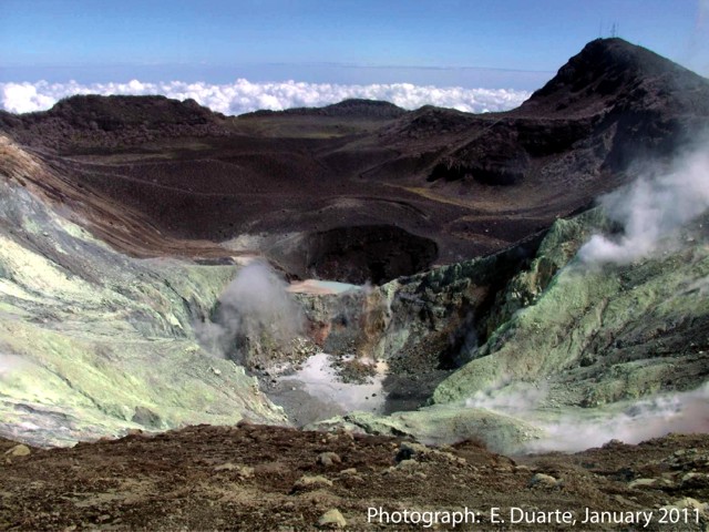 |
Figure 23. View of Turrialba's SW crater (depression in foreground) and central crater (at distance). The photo documents the character of persistent ongoing fumarolic degassing on an unstated day in January 2011. The yellow zones on the hillsides represent sulfur-bearing deposits sublimated from the sulfur-rich gas emissions. Courtesy of OVSICORI-UNA. |
After the 5-6 January eruptions, emission levels dropped. In late February 2010, scientists found a pool of molten sulfur at the base of the S crater wall with a temperature of 153°C.
OVSICORI-UNA reported that scientists visited Turrialba on 7 March 2010. A gas plume, common with this volcano, was observed that night rising 1.5 km above the crater and drifting NW. Noises from the crater were described as sounding like a jet engine and rumblings. The January 2010 vent emitted gas in March with surface temperatures between 300 and 320°C. Small blocks 3-12 cm in diameter and of different colors dominated the surface around the vent. Lithics ejected 30-50 m away from the vent measured 170°C. Incandescence seen at night originated from the vent that ejected reddish-colored tephra. Two SO2 measurements taken on or around 13 March from a ground-based spectrometer yielded 1,100 and 750 t/d, the former taken closer to the volcano.
According to OVSICORI-UNA, most of the gas emitted in April originated from the January 2010 vent; in April it produced plumes that rose 2 km above the crater rim. Gas also rose from other areas, including fissures SW of the W crater and from multiple vents and fissures in the main crater. Gas plumes mainly drifted NW, W, and SW, coinciding with areas where vegetation had suffered the greatest damage from the gases.
In April 2010, OVSICORI-UNA reported that multiple years of rain data had been collected at the station La Silvia on the W flank and was frequently found to be acidic (pH often well below 5). During 2007 though mid-2010, the rain had pH 2.8-5.7 and elevated specific conductivity (figure 24). Note that the lowest pH values on the plot were collected during 2009 and 2010.
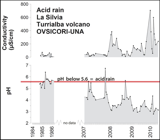 |
Figure 24. Specific conductivity (microS/cm) and pH of rainfall collected at La Silvia station associated with Turrialba during parts of the 1980s and then from 2007 through mid-2010. Note break in horizontal scale owing to absence of data. Courtesy of OVSICORI-UNA/CONARE. |
In May scientists noted that on the NW, W, SW sides there were new effects of acid-rain-damaged leaves and vegetation up to 4 km from the main crater. During August, observers noted farms 18 km SW of Turrialba with burns on onions, chemical damage attributed to volcanic gases.
A farm 3 km NW of the summit appears in comparative photos from 2007 and 2011 (figure 25). The houses in the photos were abandoned for a few months after the seismic swarms in the middle of 2007. The residents returned during February-March 2008, only to permanently leave in the middle of 2008 due to harsh atmospheric conditions. This farm remained abandoned in November 2011. Many others were also abandoned in areas of intense impact.
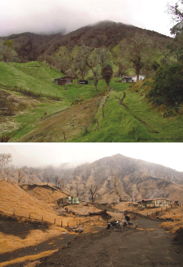 |
Figure 25. For Turrialba, comparative views from 2007 (top) and 2011 (bottom) of a farm below the crater and to the NW. These photographs show the effects of acidification on the vegetation and infrastructure. Courtesy of OVSICORI-UNA. |
Based on web camera views, the Washington Volcanic Ash Advisory Center (VAAC) reported that on 24 July 2010 a plume of steam, gas, and ash drifted W. Over the next three hours, the plume became more diffuse and steam-rich. Another ash emission was observed on 15 August 2010; the plume drifted about 600 m E of the active crater. Satellite imagery showed an approximately 10-km-wide ash plume drifting 15 km W.
The volcano was relatively quiet during November and December. In January 2011, vegetation damage from acid rain could be observed on the SW, W, and NW flanks. Residents in the village of Silvia, 2.3 km SW of the crater, reported a strong stench of SO2 during the month. On 14 January, nearby residents reported minor ashfall and rumbling noises, and again, strong sulfurous odors. OVSICORI closed the Turrialba Volcano National Park temporarily, evacuated a few people as a precaution, and installed a surveillance base in the town of La Central (~4 km SW of the crater). OVSICORI-UNA noted that a blue-and-white gas plume rose from Turrialba the next day.
During a visit to the volcano in January 2011, OVSICORI-UNA found that a 2- to 5-cm-thick layer of freshly ejected material, with clasts ranging in size from a few millimeters to 5 cm, blanketed the W edge of the crater. Officials discovered two small landslides on the walls of the crater. The walls were considered unsafe due to the loose material. The cavity in the crater that formed in January 2010 had been widened as a result of falling material and the W part of the cavity was offset by about 4 m. A new cavity in the vent appeared to have formed from one of the explosions. Heavy rainfall created a large gully, incising the W edge of the crater at a depth of 0.4-1.5 m. Despite the intense rainfall, the crater was covered in sulfur-bearing deposits. An "eerie sound," which at times could be heard kilometers from the summit, was associated with the emission of gas. A gray plume had a temperature at the vent ranging from 480-498°C.
OVSICORI-UNA reported that on 9 June 2011 scientists conducting fieldwork at Turrialba observed a new lake in the SW crater. Since February, rock landslides along with abundant mud and clay had accumulated in the bottom of the crater, blocking the vent. Meteoric water from rains starting in May had formed a light-green-colored lake that was 70 m in diameter and ~1 m deep. Minor bubbling in the SW and NE shores was noted, and steam and sulfur dioxide gas emissions rose from many fumarolic vents around the crater.
OVSICORI-UNA reported on 12 October 2011 that degassing at Turrialba had affected the vegetation, soil, infrastructure, and economy (figure 25). Acidification of the soil had impaired, possibly permanently, vegetation growth; the economic effect on farms and livestock has yet to be determined. A school building near the volcano was still used by students and teachers, despite having been deemed unsafe. The extent of the effect of acidification on livestock and the economy had not yet been determined.
Reference. OVSICORI-UNA, 2010, Real-time webcamera of Turrialba volcano, Costa Rica (URL: http://www.ovsicori.una.ac.cr/vulcanologia/videoturri.html)
Geological Summary. Turrialba, the easternmost of Costa Rica's Holocene volcanoes, is a large vegetated basaltic-to-dacitic stratovolcano located across a broad saddle NE of Irazú volcano overlooking the city of Cartago. The massive edifice covers an area of 500 km2. Three well-defined craters occur at the upper SW end of a broad 800 x 2200 m summit depression that is breached to the NE. Most activity originated from the summit vent complex, but two pyroclastic cones are located on the SW flank. Five major explosive eruptions have occurred during the past 3500 years. A series of explosive eruptions during the 19th century were sometimes accompanied by pyroclastic flows. Fumarolic activity continues at the central and SW summit craters.
Information Contacts: Observatorio Vulcanológico y Sismológico de Costa Rica-Universidad Nacional (OVSICORI-UNA), Apartado 86-3000, Heredia, Costa Rica (URL: http://www.ovsicori.una.ac.cr/); Washington Volcanic Ash Advisory Center (VAAC), Satellite Analysis Branch (SAB), NOAA/NESDIS E/SP23, NOAA Science Center Room 401, 5200 Auth Rd, Camp Springs, MD 20746, USA (URL: http://www.ospo.noaa.gov/Products/atmosphere/vaac/).