Report on Concepcion (Nicaragua) — October 2011
Bulletin of the Global Volcanism Network, vol. 36, no. 10 (October 2011)
Managing Editor: Richard Wunderman.
Edited by Julie A. Herrick.
Concepcion (Nicaragua) Early 2010 ash explosions; new instrumentation and mitigation
Please cite this report as:
Global Volcanism Program, 2011. Report on Concepcion (Nicaragua) (Herrick, J.A., and Wunderman, R., eds.). Bulletin of the Global Volcanism Network, 36:10. Smithsonian Institution. https://doi.org/10.5479/si.GVP.BGVN201110-344120
Concepcion
Nicaragua
11.538°N, 85.622°W; summit elev. 1700 m
All times are local (unless otherwise noted)
Volcanic activity at Concepción Volcano from 2007 through 2009 was characterized by intermittent, explosive eruptions of ash. Our last report, BGVN 34:11, highlighted the extent of ashfall from these eruptions and the declining frequency of explosions from 9 February through 11 December 2009. New activity reported below begins with a sequence of ash eruptions from January 2010 through early April 2010. Recent mitigation efforts are also discussed that include evacuation drills in January 2010, an international conference held in Managua with site visits to Ometepe Island in November 2010, and a new GPS network (called CONCEPTEPE).
Seismicity for the past five years from Concepción Volcano has been summarized by the Instituto Nicarag?ense de Estudios Territoriales (INETER). Low tremor (around 0.5 Hz) was frequently recorded during this time period and sporadic volcano-tectonic (VT) events occurred every 4-5 months. They also noted that intermittent summit explosions followed the same 4-5 month pattern.
Escalation and summit eruption. Volcanic unrest at Concepción Volcano from January through February 2010 was marked by few direct observations and isolated seismic events. On 27 January a small summit explosion was observed although there was no associated seismic signal; ash was not detected by weather satellites and no VAAC notices were released. Banded tremor was detected by INETER stations (2 installations are on Ometepe Island) on 11 February lasting for about 5 minutes, but there were no signs of degassing or explosions. Banded tremor is a term describing a pattern of regular increase and decrease in tremor appearing on a seismic drum (McNutt 1992), also known as intermittent volcanic tremor (IVT) (Gresta and others, 1996).
A series of explosions from Concepción's summit occurred suddenly on 7 March 2010. Low-level tremor appeared in the afternoon on 8 March and, in total, 14 ash-and-gas explosions were recorded that day (figure 5). Observers on Ometepe reported regular plume heights of ~ 1 km above the crater, and ash fell >10 km across the SW sector of the island reaching the communities Moyogalpa, Los Angeles, Esquipulas, and San José del Sur (ABC Digital). The Washington Volcanic Ash Advisory Center (VAAC) reported a 2.1 km-high plume drifting W.
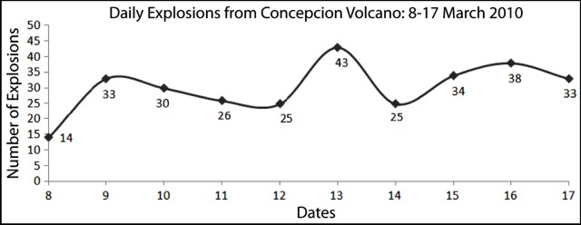 |
Figure 5. The number of daily explosions plotted over time for Concepción volcano. This time period covers the height of activity from 8-17 March 2010. Courtesy of INETER. |
By 9 March, episodes of banded tremor prevailed for over 5 minutes and the number of small explosions doubled.
On 11 March, tremor increased by 180 RSAM units (Real-time Seismic-Amplitude Measurement) and explosions were often recorded as impulsive with RSAM values of 300 (figure 6). The highest RSAM value occurred at 1440 reaching ~ 1,100. Throughout the day there were small gas-and-ash explosions and banded tremor increased slightly.
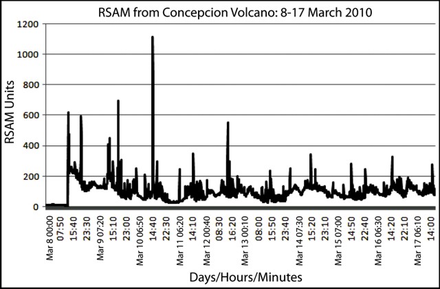 |
Figure 6. RSAM plot from Concepción volcano for 8-17 March 2010. X-axis is reported as Days/Hours/Minutes. Courtesy of INETER. |
At 0759 on 12 March an M 4.6 earthquake occurred along the coast of San Juan del Sur, ~ 100 km W of the volcano. Forty minutes after this regional earthquake, INETER reported one of the strongest ash explosions from Concepción. Residents of La Sabana, Altagracia, and neighboring communities reported ashfall at 1940 that day (noticias.com). The resulting plume was detected by weather satellites and reported in a VAAC advisory. Ash reached an altitude of ~ 3 km and drifted SE. Tremor continued to be recorded during the day by INETER instruments.
In the March 2010 report, INETER highlighted seismic events and noted that, during the first 10 days of activity, no VT events were recorded. The last VT event in this region had occurred on 25 January 2010, an M 2.8 earthquake located near Ometepe Island.
Explosive activity from Concepción's summit had dropped after 17 March, and by 25 March, gas and ash emissions were no longer reported. Two ash explosions were recorded in April and seismic events were rare. INETER reported quiescence at the volcano through the end of the year except for occasional VT events in July and one M 3.4 earthquake on 6 August 2010. Heavy rain caused signal outages on Ometepe Island in September and resulted in data gaps.
Gas measurements. During the height of Concepción's explosive activity in March 2010, teams of scientists from INETER were deployed with mobile Mini-DOAS to measure SO2 flux. One team traversed the Ometepe circular road system and measured emissions on 10, 13, and 14 March at the base of the plumes, finding values of 83 to 1,057 tons/day over this time period. A second team collected data on 9, 13, 14, and 15 March and calculated average daily values as high as 507 tons/day (figure 7).
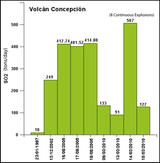 |
Figure 7. SO2 flux measured from Concepción with Mini-DOAS for four days in March as well as data from 1997, 2002, and 2005. Courtesy of INETER, Dirección de Geofísica. |
On 23 March a scientific team from Spain (Instituto Tecnológico de Energía Renovable) joined INETER to they investigate reports of thermal vents previously identified by local residents in the SW part of the island. Near the town of Pull in the Altagracia municipality, diffuse CO2 emissions were measured from small (sub-meter), rocky crevices that also had low thermal outputs (figure 8).
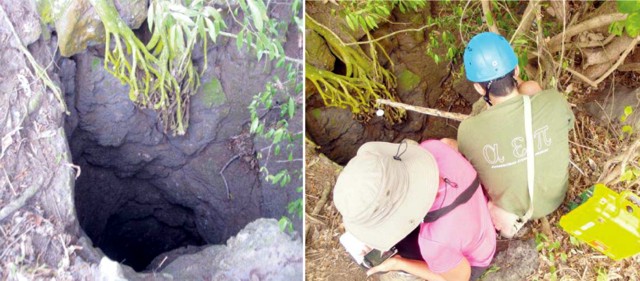 |
Figure 8. Field reconnaissance at a previously unexplored fumarole on Concepción's SW flank. Photo by INETER. |
Various reports in March from residents on the S and SE side of Concepción described new openings along the upper flanks; these features are described as fumaroles in the reports. Photos and observations were collected by INETER and included reports from several communities and Civil Defense (figure 9). In places, these cavities are on the order of several of meters wide, some appearing in one location where a fresh-water spring broke to the surface in 2005 following summit eruptions. No additional information was available to explain the cause or characteristics of these features.
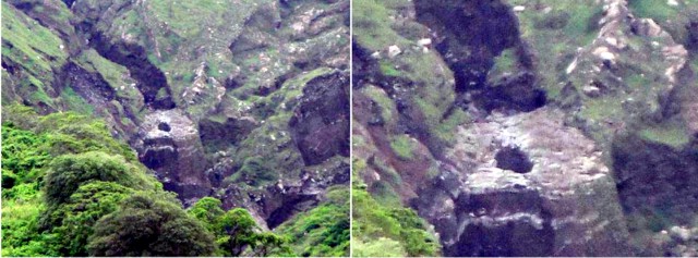 |
Figure 9. A sample of one of the various cave-like features that opened during the volcanic crisis of March 2010. The right-hand photo is a close-up of a new feature located just below a recently fractured surface. INETER did not report size estimates of these features. Photos were taken in March but dates were not specified. Photo courtesy of David Chavarría, INETER. |
Evacuation drills on 27 January 2010. INETER and the Sistema Nacional para la Prevención, Mitigación y Atención de Desastres (SINAPRED) held evacuation drills on 27 January on Ometepe Island. More than 3,000 residents participated from Moyogalpa and Altagracia, the island's municipalities. Representatives from Civil Defense, Red Cross, and local government officials helped with search-and-rescue training. The event was planned with and supported by Nicaragua's national agencies as well as CARE International and the Swiss Agency for Development and Cooperation. Formal discussions regarding hazard maps, risk assessment, and analysis of precursory activity (seismicity in particular) were held between INETER, SINAPRED, and CARE officials. Evacuation routes and representative maps were discussed with local residents. The drills measured the response capabilities and exercised decision-making on the part of the residents and local emergency management officials.
GPS network. INETER's July 2010 report described the status of a long-term, collaborative program with the Universidad de Cádiz, Spain and the Consejo Superior de Investigación Científica de Madrid (CSIC). This program ("Metodologías de vigilancia desarrolladas en España, en el sistema de vigilancia de Nicaragua") focused on implementing new monitoring systems in Nicaragua with a strong focus on Ometepe Island. After assessments and field visits in February 2010, participants designed CONCEPTEPE, an island-wide GPS network. Installation of the network began in June and continued through July 2010 and included nine permanent stations across the island and one onshore at Rivas, a town just SW of the Pan-American Highway roughly 6 km from the shoreline of Lake Nicaragua (figure 10). Additional fieldwork and equipment testing were required before this system would be fully operational. This project expanded the long-term monitoring efforts on Ometepe Island that have included meteorological stations, a seismic network, and web cameras.
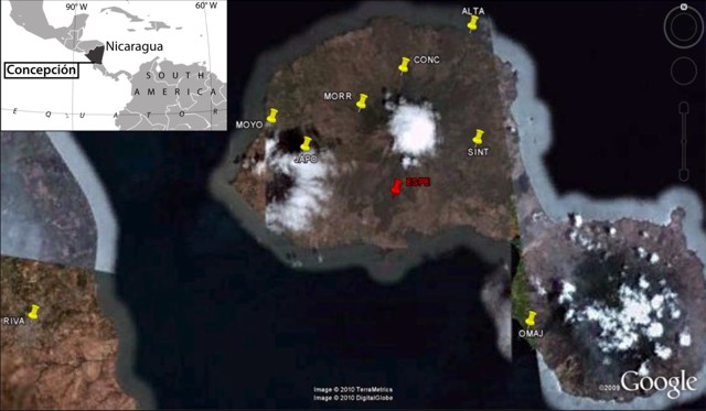 |
Figure 10. Locations of new GPS stations on Ometepe Island and one location in the town of Rivas (station RIVA) ~6 km W of the Lake Nicaragua shoreline. Courtesy of INETER (using a Google Earth base map); index map courtesy of MapsOf.net. |
International conference and Ometepe site visits. A professional meeting of geoscientists was held in Managua on 23-30 November 2010 to discuss ash, lahar, and landslide modeling techniques: "Primera Taller de la Red Iberoamericana para el Monitoreo y Modelizacion de Cenizas y Aerosoles Volcanicos y Uso de TITAN2D para Modelizacion de Lahares y Deslizamientos" (First workshop of the Iberian-Latino-American network for monitoring and modeling volcanic ash and aerosols and the use of TITAN2D for modeling lahars and landslides). Presentations focused on numerical modeling programs TITAN 2D and FALL 3D, programs that investigate mass-flow behavior and forecasting based on geotechnical parameters. Representatives from Spain, Italy, Mexico, Colombia, and Central American countries discussed new techniques for hazards assessments as well as current mitigation efforts applied at different volcanic settings.
From 26-27 November participants from this international workshop visited Ometepe Island. Field activities included sampling of recent lahars as well as mapping in order to improve maps for lahar and landslide hazard mitigation. Participants of the workshop were also invited to speak at community meetings, addressing citizens of Moyogalpa and Altagracia municipalities. The themes of these meetings centered on local risk assessment and new techniques for volcanic hazard forecasting.
References. Gresta, S., Privitera, E., Leotta, A., Gasperini, P., 1996. Analysis of the intermittent volcanic tremor observed at Mount Etna (Sicily), 1987. Ann. Geofis. 39, 421-428.
McNutt, S.R., 1992. Volcanic tremor. In: Encyclopedia of Earth System Science, vol. 4. Academic Press, pp. 417-425.
Geological Summary. Volcán Concepción is one of Nicaragua's highest and most active volcanoes. The symmetrical basaltic-to-dacitic stratovolcano forms the NW half of the dumbbell-shaped island of Ometepe in Lake Nicaragua and is connected to neighboring Madera volcano by a narrow isthmus. A steep-walled summit crater is 250 m deep and has a higher western rim. N-S-trending fractures on the flanks have produced chains of spatter cones, cinder cones, lava domes, and maars located on the NW, NE, SE, and southern sides extending in some cases down to Lake Nicaragua. Concepción was constructed above a basement of lake sediments, and the modern cone grew above a largely buried caldera, a small remnant of which forms a break in slope about halfway up the N flank. Frequent explosive eruptions during the past half century have increased the height of the summit significantly above that shown on current topographic maps and have kept the upper part of the volcano unvegetated.
Information Contacts: Instituto Nicaraguense de Estudios Territoriales (INETER), Volcanology and Geophysics Departments (URL: http://www.ineter.gob.ni/); Washington Volcanic Ash Advisory Center (VAAC) (URL: http://www.ospo.noaa.gov/Products/atmosphere/vaac/); ABC Digital: Paraguay y El Mundo (URL: http://www.abc.com.py/); Noticias.com: Noticias de Guatemala (URL: http://noticias.com.gt/internacionales/); MapsOf.net (URL: http://mapsof.net/).