Report on Zubair Group (Yemen) — November 2011

Bulletin of the Global Volcanism Network, vol. 36, no. 11 (November 2011)
Managing Editor: Richard Wunderman.
Edited by Robert Dennen.
Zubair Group (Yemen) December 2011 submarine eruption spotted by fishermen; island emerges
Please cite this report as:
Global Volcanism Program, 2011. Report on Zubair Group (Yemen) (Dennen, R., and Wunderman, R., eds.). Bulletin of the Global Volcanism Network, 36:11. Smithsonian Institution. https://doi.org/10.5479/si.GVP.BGVN201111-221020
Zubair Group
Yemen
15.05°N, 42.18°E; summit elev. 191 m
All times are local (unless otherwise noted)
Following two M 3 earthquakes in the region on 13 December 2011, fishermen in Salif City, Yemen, reported an eruption in the Zubair island group that began as late as 18 December 2011. Moderate Resolution Imaging Spectroradiometer (MODIS) images of the area also first revealed a plume on 18 December, and this and later MODIS images fixed the vent's location at a spot in the N portion of Yemen's Jebel Zubair (Zubair Group, figure 1). A new island emerged in this vicinity and was large enough to resolve in satellite imagery by 23 December 2011. The latitude and longitude given in the title for Jebel Zubair (15.05°N, 42.18°E) indicate the largest island of the Zubair Group (figure 1); the new island emerged at approximately 15.158°N, 42.101°E.
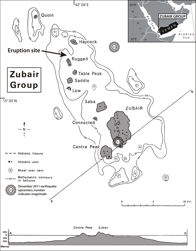 |
Figure 1. Map and index map of the 10 islands of the Zubair Group (Yemen) with our indication of the site of the new eruption and its associated emergent island. The islands emerge in the southern Red Sea, dotting an elongate region of about 8 x 27 km. Islands represented by gray shading; other features identified by legend at left. Plotted earthquake epicenters are given in table 1. The cross section at bottom is along line A-B. Modified from Gass and others (1973); index map modified from MapsOf.net. |
Initial reports. According to an article published in the Yemen Observer on 19 December, the fishermen who first reported the eruption stated that it was near Saba island (figure 1). They stated that they could see the eruption from 3 hours travel time away. The fishermen reported that the volcano had been "popping up red lava that reached 20-30 meters high." The same day, an EOS-AURA Ozone Monitoring Istrument (OMI) image showed an SO2 cloud in the area (figure 2). According to Volcano Discovery, a reader from Yemen confirmed the reported eruption, and added that an earthquake was felt on 19 December. Two other seismic events in the Zubair Group were recorded by the Seismological and Volcanological Observatory Center (SVOC) on 13 December (table 1, figure 1).
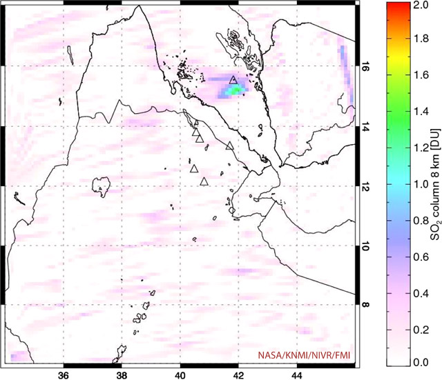 |
Figure 2. An SO2 cloud over the area of the Zubair island group captured by the AURA satellite's OMI imager between 1023 and 1205 on 19 December 2011. Scale at right is in Dobson Units (DU). The mass of SO2 depicted on this image was 0.403 kilotons (kt); the area of the cloud was ~45,352 km2; the maximum SO2 values on the image occured at 15.28°N and 14.28°E and reached 1.4 DU. Courtesy of Simon Carn and NASA Global Sulfur Dioxide Monitoring Aura/OMI. |
Table 1. Seismic events recorded in the Zubair Group in December 2011. Courtesy of the Seismological and Volcanological Observatory Center (SVOC).
| Date | Time | Location | Depth | Magnitude | Distance from eruption site |
| 13 Dec 2011 | 0122 | 15.037°N, 42.176°E | 38 km | 3.7 | 15.6 km |
| 13 Dec 2011 | 0501 | 15.167°N, 42.172°E | 6 km | 3.9 | 7.7 km |
On 20 December, the Toulouse Volcanic Ash Advisory Center (VAAC) reported a white plume that may have contained some unidentifiable ash (as reported that day from an aircraft in the area). Their report included a remark that the eruption seemed to be a continuing submarine eruption that began on 18 December. They stated that the plume was not identifiable in their satellite data. On 22 December, the Emirates News Agency published an article reporting that the head of SVOC stated that, based on preliminary data, there was no danger to marine navigation.
Small plumes were visible on MODIS imagery beginning on 18 December (figure 3). While cloud cover and dust plumes rendered the images speculative on a few days, others provided a clear view of the plumes, and highlighted their origin (figure 3f). The plumes did not appear to originate from one of the Zubair islands, but instead from just N of Rugged and ~ 1.5 km SW of Haycock islands (figure 4; also see "Eruption site" on figure 1). The lack of plumes prior to 18 December 2011, and the persistence of plumes after, indicates that the eruption began breaking the surface of the Red Sea sometime during 17-18 December.
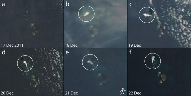 |
Figure 3. Satellite images of the Zubair Group captured during 17-22 December 2011. Images b-f show small plumes (circled) emanating from ~1.5 km SW of Haycock and just N of Rugged. A dust plume somewhat obscures the visibility in (b) and clouds are present in (c) and (d). Pixel resolution in each image is 250 m. All images acquired by the Moderate Resolution Imaging Spectroradiometer (MODIS) instrument aboard NASA's Aqua satellite except (d), which was acquired by the MODIS instrument aboard NASA's Terra satellite. Images courtesy of NASA's Land Atmosphere Near Real-time Capability for EOS (LANCE). |
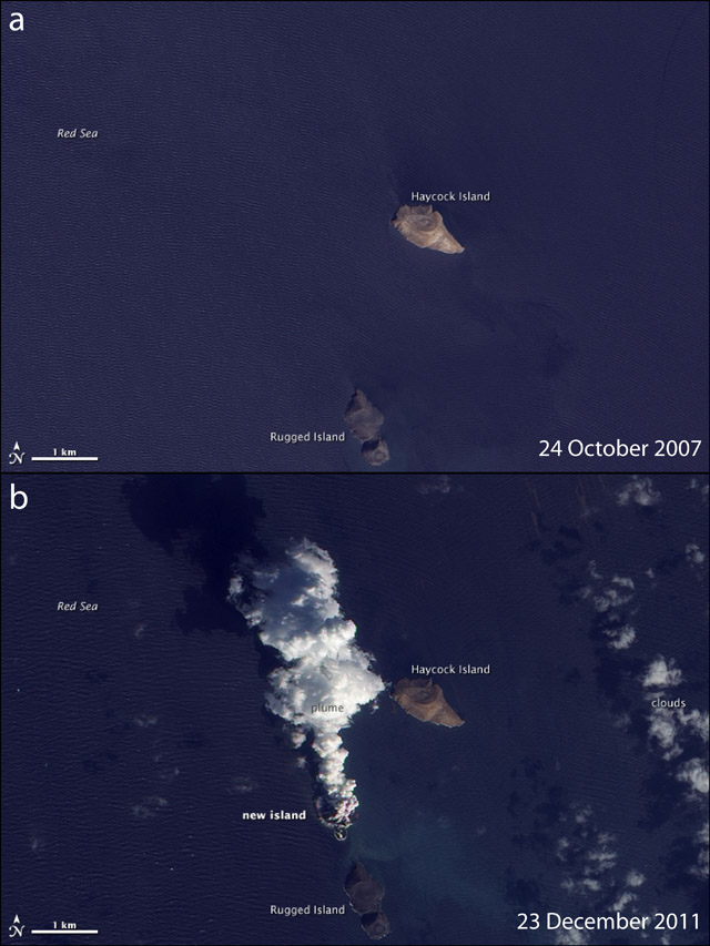 |
Figure 4. NASA Earth Observatory images captured by the Advanced Land Imager (ALI) aboard NASA's Earth Observing-1 (EO-1) satellite on (a) 24 October 2007 and (b) 23 December 2011. The 23 December 2011 image shows that an apparent new island is the eruption site, less than 1 km to the N of Rugged Island. An eruptive plume is seen rising and drifting to the N. Courtesy of Jesse Allen and Michon Scott, NASA Earth Observatory. |
New island. Finally, following approximately a week of widespread speculation on the exact location of the plume's source, NASA Earth Observatory published a high resolution satellite image of a new eruption (acquired 23 December 2011), clearly showing the off-island source of the eruptive plumes (figure 4b). From comparison with an image acquired on 24 October 2007, the 23 December 2011 image clearly shows that the eruption site was less than 1 km due N of Rugged Island, and was an apparent new island (figure 4). Their report stated that "The image . . . shows an apparent island where there had previously been an unbroken water surface." As of 28 December 2011, all information seems to point to the formation of a new, as yet unnamed, island in the Red Sea.
Reference. Gass, I.G., Mallick, D.I.J., and Cox, K.G., 1973, Volcanic islands of the Red Sea, Journal of the Geological Society of London, v. 129, p. 275-310 (DOI: 10.1144/gs
Geological Summary. The 5-km-long Jebel Zubair Island is the largest of a group of small islands and submerged shoals that rise from a shallow platform in the Red Sea rift. The platform and eruptive vents forming the islands and shoals are oriented NNW-SSE, parallel to the rift. An early explosive phase was followed by a brief period of marine erosion, then by renewed explosive activity accompanied by the extrusion of basaltic pahoehoe lava flows. This latest phase of activity occurred on the morphologically youngest islands of Zubair, Centre Peak, Saba, and Haycock. Historical explosive activity was reported from Saddle Island in the 19th century. Spatter cones and pyroclastic cones were erupted along fissures that form the low spine of Zubair Island. Eruptions that began in late 2011 built two new islands, increasing the total number in the group to 12.
Information Contacts: MapsOf.net (URL: http://mapsof.net/); The Yemen Observer, P.O. Box 19183, Sana'a, Rep. of Yemen (URL: http://www.yobserver.com/); Seismological and Volcanological Observatory Center (SVOC), P.O. Box 87175, Dhamar, Yemen (URL: http://www.nsoc.org.ye/); Simon Carn, NASA Global Sulfur Dioxide Monitoring, Aura/OMI (URL: https://so2.gsfc.nasa.gov/); Toulouse Volcanic Ash Advisory Center (VAAC), Météo France, 42 Avenue Gaspard Coriolis, 31057 Toulouse Cedex 1, France (URL: http://www.meteo.fr/vaac/eindex.html); Emirates News Agency, 3790 Abu Dhabi, United Arab Emirates (URL: http://wam.org.ae/); NASA's Land Atmosphere Near Real-time Capability for EOS (LANCE) (URL: http://lance.nasa.gov/); NASA Earth Observatory (Jesse Allen and Michon Scott), NASA Goddard Space Flight Center (URL: http://earthobservatory.nasa.gov/).