Report on Popocatepetl (Mexico) — November 2011
Bulletin of the Global Volcanism Network, vol. 36, no. 11 (November 2011)
Managing Editor: Richard Wunderman.
Popocatepetl (Mexico) Seismicity and small ash plumes continue through December 2011
Please cite this report as:
Global Volcanism Program, 2011. Report on Popocatepetl (Mexico) (Wunderman, R., ed.). Bulletin of the Global Volcanism Network, 36:11. Smithsonian Institution. https://doi.org/10.5479/si.GVP.BGVN201111-341090
Popocatepetl
Mexico
19.023°N, 98.622°W; summit elev. 5393 m
All times are local (unless otherwise noted)
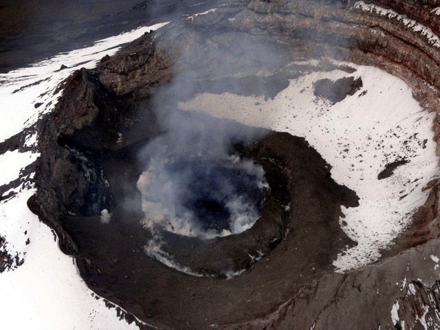
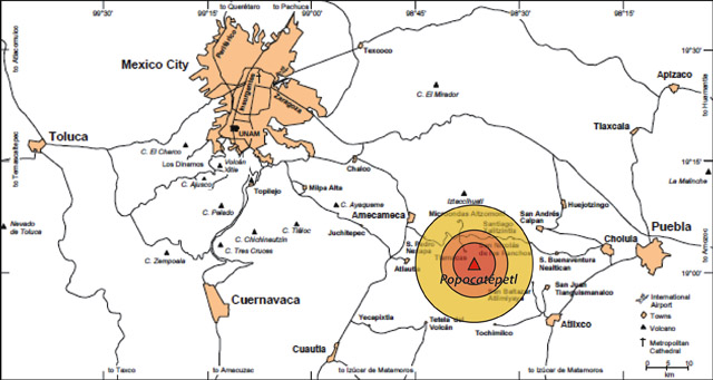
Popocatépetl continued to be active during September 2010 to 13 December 2011 with explosions, tremor, and frequent gas-and-steam emissions occasionally containing ash (figure 59). This report continues the table in the previous report (BGVN 35:08) that tallies the seismic activity and ash emissions (table 21). Figure 60 shows the proximity of the volcano to population centers.
 |
Figure 59. Photograph of the lava dome at Popocatépetl taken on 8 September 2011. Courtesy of CENAPRED. |
Table 21. Reported plumes above Popocatépetl's summit crater that contained some ash between 5 October 2010 and 13 December 2011. Data provided by the MWO (Mexico City Meteorological Watch Office), Washington Volcanic Ash Advisory Center (VAAC), and Centro Nacional de Prevención de Desastres (CENAPRED), abbreviated CEN.
| Dates | Height above crater or altitude | Plume Direction | Report Source | Comments |
| 05 Dec 2010 | -- | -- | VAAC | Small and brief emission of gas and ash. |
| 31 Jan 2011 | 2 km | E | CEN, VAAC | Explosion ejected incandescent fragments to 500 m down E flank and produced ash plume that drifted more than 275 km NE. |
| 02-04, 06 Mar 2011 | 9.1 km alt | 130 km SE (3 March) | CEN, VAAC | Steam-and-gas emissions, occasionally with small ash amounts. |
| 09-14 Mar 2011 | -- | -- | CEN | Steam-and-gas emissions, occasionally with small ash amounts. |
| 26-27 Mar 2011 | 6.4 km alt | 140 km ESE, SE; 150 km E | VAAC | Gas-and-ash plume on 26 March; another ash plume on 27 March. |
| 14-17 May 2011 | 6.7 km alt | SSW (17 May) | CEN | Steam-and-gas emissions, occasionally with small ash amounts. |
| 19 May 2011 | -- | SW | CEN | Steam-and-gas emissions, occasionally with small ash amounts. |
| 22-23 May 2011 | 6.7 km alt | SSW | VAAC | Rapidly dissipating area of ash about 650 km SW. |
| 30 May 2011 | 6.2-6.4 km alt | E, SW | CEN, VAAC | -- |
| 31 May-01 Jun 2011 | -- | -- | -- | Steam-and-gas emissions, occasionally with small ash amounts. |
| 03 Jun 2011 | 8.2-8.4 km alt; 6.4 km alt | W, SW (lower); E, ENE (upper); W | CEN, VAAC | Two ash plumes followed seismic tremors, one plume expelled for 23 minutes; ashfall in Tetela del Volcán (20 km SW), Zacualpan (31 km SW), Jonacatepec (43 km SW), and Axochiapan (60 km SSW). |
| 04 Jun 2011 | 1 km | SSW (lower); NE (upper) | CEN | -- |
| 09 Aug 2011 | 1 km | W | CEN | -- |
| 11-12 Aug 2011 | -- | -- | CEN | Steam-and-gas emissions, occasionally with small ash amounts. |
| 28-31 Aug 2011 | 1 km | WNW | CEN, VAAC | Emission of gas, steam, and some ash. During 30-31 Aug, 111 emissions with periods of harmonic tremor. Possible lahars. On 30 Aug, ashfall on San Pedro Nexapa (14 km NW) and Amecameca (19 km NW). |
| 01-04 Sep 2011 | -- | -- | CEN | 4-12 daily emissions of gas, steam, and some ash, with tremors. |
| 26 Sep 2011 | 2.5 km | -- | CEN | Explosion ejected incandescent fragments and an ash plume. Following the explosion, 11 gas-and-steam plumes with small amounts of ash. |
| 19-23 Oct 2011 | -- | -- | CEN | Steam-and-gas emissions, occasionally with small ash amounts. |
| 16-20 Nov 2011 | 7.6, 9.1, and 6.4 km alt | SW, E, N | CEN, VAAC | Steam-and-gas emissions; two ash plumes on 18 Nov. Ash plume from explosion on 20 Nov. |
| 21-28 Nov 2011 | -- | -- | CEN | Steam-and-gas plumes. Crater incandescence most nights and early mornings. |
| 29 Nov-06 Dec 2011 | 6.7 km alt (5 Dec) | NE | CEN, VAAC | Steam-and-gas plumes, containing small amounts of ash on 29, 30 Nov and 5 Dec. Crater incandescence most nights and early mornings. |
| 07-13 Dec 2011 | -- | 12.9 km W (7 Dec) | CEN, VAAC | Steam-and-gas plumes, occasionally containing small amounts of ash. On 7 December ashfall was reported in San Pedro (13.5 km NW). Crater incandescence during 9-11 December and on 9 December incandescent ballistic fragments were observed on the upper slopes of the cone. |
During the reporting interval, there were a large number of MODVOLC thermal alerts for Popocatépetl.
Arana-Salinas and others (2010) discuss the Ochre Pumice Sequence, a major (VEI 6) event that occurred ~ 5,000 years ago. That unit contained a sequence of pyroclastic flow and fall deposits that covered ~ 300 km2 directed NNE. The erupted magma amounts to a (dense rock equivalent) volume of ~2 km3. The authors stated that, depending on the wind direction, an equivalent event today would impact 15 million residents of Mexico City (the Capital), Puebla, Atlixco, and Cuautla and elsewhere, and it would severely damage infrastructure.
Reference. Arana-Salinas, L., Siebe, C., Macías, J.L, 2010, Dynamics of the ca. 4,965 yr 14C BP "Ochre Pumice" Plinian eruption of Popocatépetl volcano, México: Journal of Volcanology and Geothermal Research v. 192. p. 212-231.
Geological Summary. Volcán Popocatépetl, whose name is the Aztec word for smoking mountain, rises 70 km SE of Mexico City to form North America's 2nd-highest volcano. The glacier-clad stratovolcano contains a steep-walled, 400 x 600 m wide crater. The generally symmetrical volcano is modified by the sharp-peaked Ventorrillo on the NW, a remnant of an earlier volcano. At least three previous major cones were destroyed by gravitational failure during the Pleistocene, producing massive debris-avalanche deposits covering broad areas to the south. The modern volcano was constructed south of the late-Pleistocene to Holocene El Fraile cone. Three major Plinian eruptions, the most recent of which took place about 800 CE, have occurred since the mid-Holocene, accompanied by pyroclastic flows and voluminous lahars that swept basins below the volcano. Frequent historical eruptions, first recorded in Aztec codices, have occurred since Pre-Columbian time.
Information Contacts: Centro Nacional de Prevención de Desastres (CENAPRED), Av. Delfín Madrigal No.665. Coyoacan, México D.F. 04360, México (URL: https://www.gob.mx/cenapred/); Washington Volcanic Ash Advisory Center (VAAC), Satellite Analysis Branch (SAB), NOAA/NESDIS E/SP23, NOAA Science Center Room 401, 5200 Auth Rd, Camp Springs, MD 20746, USA (URL: http://www.ospo.noaa.gov/Products/atmosphere/vaac/); MODVOLC, Hawai'i Institute of Geophysics and Planetology (HIGP), MODVOLC Thermal Alerts System, School of Ocean and Earth Science and Technology (SOEST), Univ. of Hawai'i, 2525 Correa Road, Honolulu, HI 96822, USA (URL: http://modis.higp.hawaii.edu/).


