Report on Seulawah Agam (Indonesia) — December 2011
Bulletin of the Global Volcanism Network, vol. 36, no. 12 (December 2011)
Managing Editor: Richard Wunderman.
Edited by Robert Dennen.
Seulawah Agam (Indonesia) 172-year repose continues despite seismic crisis of September 2010-July 2011
Please cite this report as:
Global Volcanism Program, 2011. Report on Seulawah Agam (Indonesia) (Dennen, R., and Wunderman, R., eds.). Bulletin of the Global Volcanism Network, 36:12. Smithsonian Institution. https://doi.org/10.5479/si.GVP.BGVN201112-261020
Seulawah Agam
Indonesia
5.4472°N, 95.6555°E; summit elev. 1309 m
All times are local (unless otherwise noted)
Seismicity at Seulawah Agam volcano, Indonesia, caused the Center for Volcanology and Geological Hazard Mitigation (CVGHM) to raise the Alert Level from 1 to 2 (on a scale from 1-4) from 1 September 2010 through 11 July 2011. According to historical records, Seulawah Agam last erupted in 1839, although the likelihood and character of that eruption is in debate.
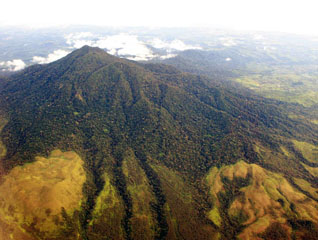
The summit of Seulawah Agam hosts a forested crater ~400 m wide (figure 1). The volcano also hosts several active fumarole fields, such as those in the van Heutsz crater, which sits on the NNE flank at ~650 m elevation (figure 2).
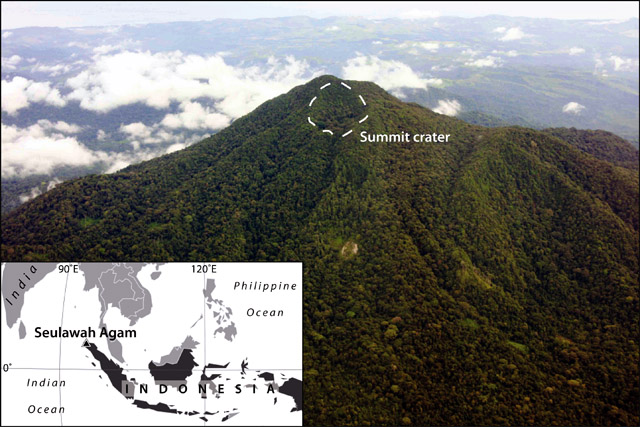 |
Figure 1. (Index map) The location of Seulawah Agam at the NW end of Sumatra island. (photo) Annotated aerial photograph of Seulawah Agam taken on 19 November 2007 looking SE, showing the ~400-m-wide, vegetated summit crater (white dashed outline). Photograph courtesy of Michael Thirnbeck; index map modified from MapsOf.net. |
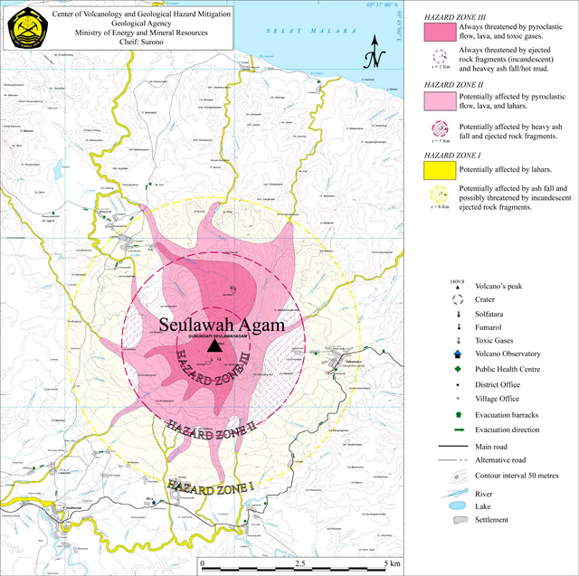 |
Figure 2. Hazard map of Seulawah Agam. Hazard Zones I-III (from outer to innermost) consist of both circular areas (indicating hazards from material dispersed through the air) and irregularly shaped areas (funneled by topography along the ground). Courtesy of the Center for Volcanology and Geological Hazard Mitigation (CVGHM). |
The hazard zones, as with all other monitored Indonesian volcanoes, concern airborne ejected/explosive material (circular zones delineating areas prone to ash fall and/or pyroclastic bombs) and ground-traveling, topographically controlled processes (irregular shaped zones delineating areas prone to lava flows, pyroclastic flows, and/or lahars); each Hazard Zone level (I-III) thus delineates a circular and an irregular area. At Seulawah Agam, the hazard zones are centered at the summit of the volcano. The van Heutsz crater, however, is located outside of the 2 km radius of Hazard Zone III, but within the topographically prone area of Hazard Zone III.
Seismicity increase. Beginning in April through September 2010 seismicity fluctuated at Seulawah Agam, although increased overall, indicating increased activity of the volcano. The Jakarta Post reported that CVGHM recorded 80 volcanic earthquakes during August 2010, the equivalent of nearly 3 volcanic earthquakes per day. On 1 September, CVGHM raised the Alert Level to 2, and restricted access to areas within 3 km of the summit crater (figure 2).
According to CVGHM, seismicity fluctuated at elevated levels from October 2010 through June 2011. In July, seismicity was still elevated above the baseline during October 2010-June 2011. However, the occurrence of shallow volcanic earthquakes was reduced compared to recent trends (table 2).
Table 2. Seismicity at Seulawah Agam during 1 October 2010-10 July 2011. The Alert Level was lowered from 2 to 1 (on a scale from 1-4) on 11 July 2011. Data courtesy of the Center for Volcanology and Geological Hazard Mitigation (CVGHM).
| Date | Shallow volcanic | Deep volcanic | Local tectonic | Distant tectonic |
| Oct 2010-May 2011 | 12-65 / month | 28-116 / month | 14-30 / month | 55-138 / month |
| Jun 2011 | 77 / month | 74 / month | 15 / month | 74 / month |
| 01-10 Jul 2011 | 12 / 10 days | 20 / 10 days | 15 / 10 days | 20 / 10 days |
CVGHM also reported that comparison of data from October 2010 and February 2011 indicated a decline in the emission of volcanic gases, a stabilization of the pH of crater waters, and a decrease in the measured temperature of fumaroles. On 11 July 2011, CVGHM lowered the Alert Level to 1, restricting access only to the summit crater.
Geological Summary. Seulawah Agam, near the NW tip of Sumatra, is an extensively forested volcano with a small summit crater. It was constructed within the large Pleistocene Lam Teuba caldera, which also contains a smaller 6 x 8 caldera. The van Heutsz crater is an active fumarolic area on the NNE flank extending about 200 m downslope around 700 m elevation; it does not have the appearance of a volcanic crater. Additional geothermal areas are noted by Marwan et al. (2021). Sapper (1927) and Neumann van Padang (1951 CAVW) listed an explosive eruption in the early 16th century, and the CAVW also listed an eruption from the van Heutsz crater in 1839. However, Rock et al. (1982) found no evidence for historical eruptions. The Volcanological Survey of Indonesia also noted that although no reported eruptions have occurred from the main cone, the NNE-flank activity may have only been hydrothermal.
Information Contacts: Center for Volcanology and Geological Hazard Mitigation (CVGHM), Jl. Diponegoro 57, Bandung, West Java, Indonesia, 40 122 (URL: http://www.vsi.esdm.go.id/); TheJakarta Post, Jl. Palmerah Barat 142-143, Jakarta 10270 (URL: http://www.thejakartapost.com/); Michael Thirnbeck (URL: http://www.flickr.com/photos/thirnbeck/); MapsOf.net (URL: http://mapsof.net/).