Report on Additional Reports (Unknown) — December 2011

Bulletin of the Global Volcanism Network, vol. 36, no. 12 (December 2011)
Managing Editor: Richard Wunderman.
Additional Reports (Unknown) South Sandwich Islands, East Scotia Ridge: Study describes submarine venting and eruption in back-arc setting
Please cite this report as:
Global Volcanism Program, 2011. Report on Additional Reports (Unknown) (Wunderman, R., ed.). Bulletin of the Global Volcanism Network, 36:12. Smithsonian Institution. https://doi.org/10.5479/si.GVP.BGVN201112-600500
Additional Reports
Unknown
Lat Unknown, Unknown; summit elev. m
All times are local (unless otherwise noted)
Rogers and others (2012) reported on the presence of black smokers, diffuse venting, and associated chemosynthetically-driven ecosystems along the East Scotia Ridge (ESR), a geographically isolated back-arc spreading center in the Atlantic sector of the Southern Ocean, near Antarctica (figure 1). To their best knowledge, this was the first time that these features were observed at this location. Rogers and others (2012) noted that, since the discovery of hydrothermal vents along the Galápagos Ridge in 1977 (Corliss and others, 1979), scientists have detected “numerous vent sites and faunal assemblages at many mid-ocean ridges and back-arc basins...an apparent global biogeography of vent organisms with separate provinces.”
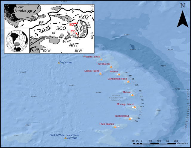 |
Figure 1. (Inset) Map of the Scotia Sea, showing the ESR in relation to the Scotia plate (SCO), the South Sandwich plate (SAN), the South American plate (SAM), the Antarctic plate (ANT), the Antarctic Peninsula (AP), and the South Sandwich trench (SST). Oceanographic features shown include the Polar front (PF), the Sub-Antarctic front (SAF), and the southern Antarctic Circumpolar Current front (SACCF). The vents sites E2 and E9, locations of the detailed studies discussed here, are indicated by red arrows. (Larger image) Map of the South Sandwich islands showing known active island volcanoes (red triangles) relative to the South Sandwich trench, and the East Scotia ridge (ESR) and submarine vents (E9) and fissure (E2, Dog’s Head) discussed here. Index map after Rogers and others (2012); ocean-floor base map from GEBCO, NOAA National Graphic, DeLorme, and ESRI. |
Vent sites E2 and E9. The vent site E2 lies just S of the segment axial high (called the Mermaid’s Purse), between 56°5.2’ and 56°5.4’S and between 30°19’ and 30°19.35’W at ~2,600 m depth (figures 2A and 2B). Prominent N-trending structural fabric seen on the seafloor defines a series of staircased, terraced features that are divided by W-facing scarps (figures 2B and 2C). A major steep-sided fissure runs N-S through the center of the site, between longitude 30°19.10’W and 30°19.15’W (figure 2C). The main hydrothermal vents are located at the intersection between this main fissure and a W-striking fault or scarp, consistent with the expected location of active venting on back-arc spreading ridges such as the case at hand.
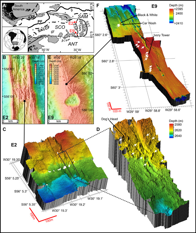 |
Figure 2. Swath maps of the location and setting of ESR vents. (A) Ship-based swath bathymetry at the location of site E2 showing the axial summit graben. The black circle indicates the sites of main venting. (B) and (C) ROV-based 3-D swath bathymetry of site E2 and high-resolution swath bathymetry of the major steep-sided fissure that runs N-S through the center of the site, between longitude 30°19.10’W and 30°19.15’W. Dog’s Head vent is indicated in panel C. White arrows indicate vents not mentioned in text. (D) Ship-based swath bathymetry at the location of site E9 showing the axial fissures and the collapsed crater called the Devil’s Punchbowl. The black spot indicates the sites of main venting. (E) ROV-based 3-D swath bathymetry of the site E9. The vents Ivory Tower, Car Wash, and Black and White are indicated. Other vents are indicated by white arrows. From Rogers and others (2012). |
Relict (extinct) and actively venting chimneys were both resolvable in the high-resolution multibeam bathymetry obtained by the ROV (remotely operated vehicle) Isis, clustered in a band running approximately NW-SE. Numerous volcanic cones and small volcanic craters are also apparent around the vent field. Chimneys of variable morphology were up to 15 m tall and venting clear fluid with a maximum measured temperature of 352.6°C. These formed focused black smokers on contact with cold seawater (figure 3A).
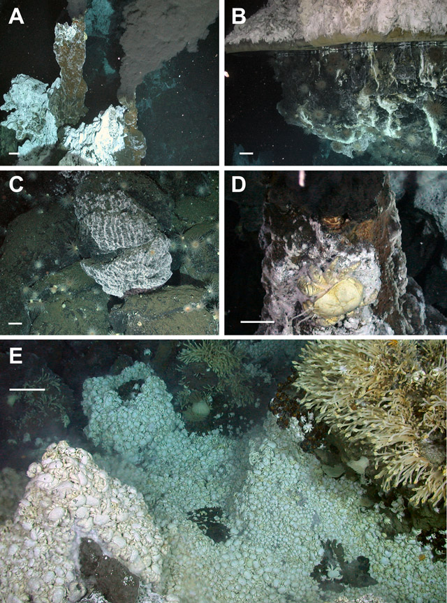 |
Figure 3. Photographs of vents and associated biological communities. (A) Active black smoker chimneys at vents site E2 (2,602 m depth). Note the chimneys emitting dark-colored chemical-laden water into the seabed through vents, hitting cold seawater and causing metallic sulfides to precipitate. (B) Vent flange at E2 with trapped high-temperature reflective hydrothermal fluid (2,621 m depth). (C) Microbial mat covering rock surfaces on vent periphery at E2 (2,604 m depth). (D) Active vent chimney at vents site E9 supporting the new species of the anomuran yeti crab Kiwa (2,396 m depth). (E) Dense mass of the anomuran crab (Kiwa n. sp.) at E9 with the stalked barnacle (cf. Vulcanolepas) attached to nearby chimney (2,397 m depth). Scale bars: 10 cm for foreground. Courtesy of Rogers and others (2012). |
Some of the chimneys have expanded tops with hot (above 300°C) vent fluid emanating from the underside (figure 3B), similar to the flanges found at North East Pacific vents. Diffuse vent flow was observed at a variety of locations, with temperatures varying from 3.5 to 19.9°C, compared with a background temperature of ~0.0°C. Around the periphery of the active high-temperature vents and diffuse flow sites are microbial mats that form a halo around the venting area at E2 (figure 3C).
Site E9 is situated between 60°02.5’ and 60°03.00’S and between 29°59’ and 29°58.6’W, at ~2,400 m depth, amongst relatively flat sheet lavas to the N of a major collapse crater named the Devil’s Punchbowl (figure 2D). The ridge axis is heavily crevassed and fissured, with numerous collapse features, lava drain-back features, and broken pillow lava ridges. Major fissures run NNW-SSE through the site, breaking up an otherwise flat and unvaried terrain (figure 2E).
Topographic highs in the center of the study site lack hydrothermal activity and thus are possibly inactive magma domes. Most active venting appears to lie along one of the smaller fissures, W of a main N-trending feature. Diffuse flow and black smokers line the feature intermittently, but activity becomes reduced and dies away farther S, towards the “Punchbowl.” The chimneys were either emitting high-temperature fluids with a maximum temperature of 382.8°C (Ivory Tower; figure 3E) or had lower temperature diffuse flow, between 5 and 19.9°C (Car Wash vent; figure 3E). Low-temperature diffuse flow was associated with fissures and fine cracks in the sheet lava; the background temperature at E9 varied from -0.11 to -1.3°C.
Deep-sea hydrothermal vents. The ESR vents can be seen in the broader context of deep-sea hydrothermal vents. Hydrothermal vents are essentially hot springs on the ocean floor.
Figure 4 shows the locations of many of the Earth’s known deep-sea hydrothermal vent systems. International Cooperation in Ridge-Crest Studies (InterRidge - a non-profit international organization promoting mid-ocean ridge research) created this map for the International Seabed Authority to show locations of vents that should be protected from exploitation.
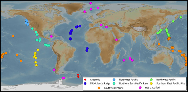 |
Figure 4. Deep-sea hydrothermal vent systems that require protection from exploitation, according to InterRidge (Chown, 2012). Vent biogeographic provinces identified by Bachraty and others (2009) are displayed using color, and the two East Scotia Ridge vents sites described by Rogers and others (2012) are indicated with diamonds, just to the east of the Antarctic Peninsula. A full list of vent sites can be found on InterRidge’s web pages (see Information Contacts, below). The base map is the NOAA global relief model. Modified from Chown (2012); figure compiled by Aleks Terauds. |
References. Bachraty C., Legendre, P., and Desbruyères, D., 2009, Biogeographic relationships among deep-sea hydrothermal vent faunas at global scale, Deep Sea Research, Part I, v. 56, no. 8, p. 1371-1378.
Chown, S.L., 2012, Antarctic marine biodiversity and deep-sea hydrothermal vents, PLoS Biology, v. 10, no. 1, e1001232. doi:10.1371/journal.pbio.1001232 (URL: http://www.plosbiology.org/article).
Corliss, J.B.. Dymond, J., Gordon, L.I., Edmond, J.M., von Herzen, R.P., Ballard, R.D., Green, K., Williams, D., Bainbridge, A., Crane, K., and van Andel, T.H., 1979, Submarine thermal springs on the Galapagos Rift, Science, v. 203, no. 4385, p. 1073-1083. doi: 10.1126/science.203.4385.1073.
InterRidge, 2012, InterRidge Vents Database (URL: http://www.interridge.org/irvents).
Rogers, A.D., Tyler, P.A., Connelly, D.P., Copley, J.T., James, R., Larter, R.D., Linse, K., Mills, R.A., Garabato, A.N., Pancost, R.D., Pearce, D.A., Polunin, N.V.C., German, C.R., Shank, T., Boersch-Supan, P.H., Alker, B.J., Aquilina, A., Bennett, S.A., Clarke, A., Dinley, R.J.J., Graham, A.G.C., Green, D.R.H., Hawkes, J.A., Hepburn, L., Hilario, A., Huvenne, V.A.I., Marsh, L., Ramirez-Llodra, E., Reid, W.D.K., Roterman, C.N., Sweeting, C.J., Thatje, S., and Zwirglmaier, K., 2012, The discovery of new deep-sea hydrothermal vent communities in the Southern Ocean and implications for biogeography, PloS Biology, v. 10, no. 1, e1001234. doi: 10.1371/journal.pbio.1001234 (URL: http://www.plosbiology.org/article).
Geological Summary. Reports of floating pumice from an unknown source, hydroacoustic signals, or possible eruption plumes seen in satellite imagery.
Information Contacts: International Cooperation in Ridge-Crest Studies (InterRidge) (URLs: http://www.interridge.org; http://www.interridge.org/irvents); VENTS Program, Pacific Marine Environmental Laboratory (PMEL), National Oceanographic and Atmospheric Administration (NOAA) (URL: http://www.pmel.noaa.gov/vents/).