Report on Cleveland (United States) — January 2012
Bulletin of the Global Volcanism Network, vol. 37, no. 1 (January 2012)
Managing Editor: Richard Wunderman.
Cleveland (United States) Amendments to BGVN reports 2001-2011
Please cite this report as:
Global Volcanism Program, 2012. Report on Cleveland (United States) (Wunderman, R., ed.). Bulletin of the Global Volcanism Network, 37:1. Smithsonian Institution. https://doi.org/10.5479/si.GVP.BGVN201201-311240
Cleveland
United States
52.825°N, 169.944°W; summit elev. 1730 m
All times are local (unless otherwise noted)
Our last report on Cleveland volcano, August 2011 (BGVN 36:08), described lava dome growth in August-September 2011. This report first addresses late 2011 to early 2012 observations, and then presents some amendments to Bulletin reports over the last decade.
Late 2011-early 2012. According to the Alaska Volcano Observatory (AVO), by the first week of October 2011 satellite images showed the lava dome was within 10 m of the crater rim on the SW and ENE sides of the crater. On 23 October, a TerraSAR-X satellite radar image of Cleveland showed no discernable growth in the lava dome over the course of the past several weeks. Instead, the 23 October image showed deflation or collapse of the dome.
On 3 November 2011, citing lack of dome growth evident in satellite images, AVO lowered both the Aviation Color Code to YELLOW and the Alert Level to ADVISORY. Throughout November, weather permitting, AVO continued to observe thermal anomalies and steam plumes in satellite imagery, consistent with cooling of the emplaced hot dome. Observations in early December 2011 showed continued deflation and cooling of the lava dome, which was about 1x10⁶ m3 in volume.
On 29 December 2011, AVO observed in satellite imagery a detached, drifting ash cloud at an altitude of ~4.6 km and ~80 km ESE of Cleveland. Ground-coupled airwaves from an explosion were also detected at the distant Okmok seismic network, placing the time of explosion at 1312 (UTC) on 29 December 29.
Based on the presence of an ash cloud, on 29 December AVO raised the aviation color code to ORANGE and the alert level to WATCH. On 30 December, with no new explosive activity, AVO lowered the aviation color code to YELLOW and the alert level to ADVISORY. Subsequent satellite images showed that the 25 December (recognized in retrospective data analysis) and 29 December explosions had largely removed the dome.
On 30 January 2012, satellite data showed another small dome within the summit crater, which measured ~ 40 m in diameter by 30 January. On 31 January, AVO raised the aviation color code to ORANGE and the volcano alert level to WATCH. No observations of elevated surface temperatures or ash emissions from Cleveland were noted during 15-21 February. On 17 February, AVO reported that partly-cloudy satellite observations over the past week revealed that the current lava dome had grown to about 60 m in diameter and occupied a small portion of the approximately 200-m diameter summit crater. On 19 February an elevated surface temperature was detected in satellite images. As of this date, there is no real-time seismic monitoring network on Mount Cleveland.
Amendments to Bulletin. According to Diefenbach, Guffanti, and Ewert, (2009), "During the past 29 years, 43 volcanoes within the United States have produced 95 eruptions and 32 episodes of unrest. More than half of the 30 eruptive volcanoes have erupted two or more times. The majority (77 percent) of U.S. eruptions has occurred in Alaska. Akutan volcano in Alaska has produced the most eruptions (11) in the past 29 years, followed by Veniaminof (10), Cleveland (9), and Pavlof (8)."
Because of the relative importance of Cleveland in the Aleutian chain as a source of active volcanism along a busy commercial airline route, we revisited the AVO web site recently to compare information available with that which we used to prepare the Bulletin in the past. As a prelude to this section, table 4 lists Cleveland eruptions reported by the AVO during 2001-2012 and the issues of the Bulletin covering a particular event.
Table 4. Dates of significant eruptions as reported by the AVO web site for Cleveland from January 2001 through January 2012, and related BGVN reports covering the respective eruptions. These data were accessed 9 February 2012; as of that date, the latest eruption reported by AVO was the one of 19 July 2011. From the AVO web site.
| Item | Eruption dates (start-stop; ? = questionable event) | BGVN issue(s) |
| a | 02 Feb-15 Apr 2001 | 26:01, 26:04 |
| b | 27 Apr-27 Sep 2005 | 30:09 |
| c | 06 Feb-06 Feb 2006 | 31:01, 31:06 |
| d | 23 May-23 May 2006 | 31:06, 31:07 |
| e | 24 Aug-28 Oct 2006 | 31:09 |
| f | Jun 2007-28 Oct 2008 | 33:02, 33:07 |
| g | 02 Jan-21 Jan 2009 | 33:11 |
| h | 26 Jun-26 Jun 2009 | 34:10 |
| i | 02 Oct-02 Oct 2009 | 34:10 |
| j | 30 May-02 Jun 2010 | 35:06 |
| k | 12 Sep-12 Sep 2010 (?) | 36:05 |
| l | 19 Jul 2011 ± 7 days | 36:08 |
We amend some of our previous Bulletin reports with the following excerpts from USGS reports of Cleveland eruptions since 2001, ending with the last Bulletin containing a report on Cleveland (BGVN 36:08). The dates for the eruptions are the start and stop dates from the USGS reports.
Item a, Table 4 - BGVN 26:01: On 19 February 2001, Cleveland volcano erupted explosively at ~1430 UTC and AVO established the eruption termination date as 15 April 2001. However, after the eruption, AVO received reports indicating that precursory emission activity had taken place. Most graphic was a photograph taken on 2 February 2001 by a pilot flying by the volcano showing a dark, lobate deposit on the snow-covered SW flank and robust steaming from the summit crater.
Item a, Table 4 - BGVN 26:04: According to AVO, in 2001, ash fall from the February 2001 eruption of Cleveland was observed only at Nikolski over a ~5 hr on 19 February 2001. A sample from Nikolski showed that the ash was composed of glass shards, crystals, and lithics. The glass was dacitic and had a magmatic morphology rather than phreatomagmatic.
Item b, Table 4 - BGVN 30:09: On 27 April 2005, the Federal Aviation Association (FAA) alerted AVO of a pilot report of eruptive activity (ash cloud 4.6-5.5 km altitude) in the vicinity of Cleveland (based on coordinates from the pilots). Although satellite images and nearby seismic stations showed no evidence of activity, a one-time Urgent Pilot Report and a one-time SIGMET were issued.
Item c, Table 4 - BGVN 31:01: AVO noted that by the end of 6 January 2006 there were no further reports or images of ash production at Cleveland.
Item f, Table 4 - BGVN 33:02: Satellite data from February 2007 revealed evidence of recent activity involving ejection of bombs and debris on the upper flanks and generation of water-rich flows that traveled halfway to the coast. No ash emissions or ash fall deposits were observed. This level of activity -accompanied by persistent thermal anomalies - occurred throughout the spring and early summer. On 4 March 2008, a pilot reported minor ash to 1.5 km above sea level in the vicinity of Cleveland, and a weak thermal anomaly was observed the following day.
Item g, Table 4 - BGVN 33:11: The volcano was relatively quiet until 28 October 2008, when an ash cloud rising to ~4.6 km and drifting E was spotted in satellite imagery. On 29 October, another cloud, 160 km long and drifting NE at an altitude of 3.0 km with little or no ash was observed. A strong thermal anomaly over the summit of the volcano was noted on 30 October 2008, but given the low-level nature of the recent activity, AVO did not elevate the Color Code or Alert Level.
Item k, Table 4 - BGVN 36:05: AVO continued to detect thermal anomalies on 14, 15, 25, and 26 September 2010, and 1 October. During the other days, clouds prevented satellite observation of Cleveland. Although the weather usually prevented observations of Cleveland, weak thermal anomalies were also detected on 14, 19, 25, and 29 October 2010. Clouds completely obscured observations for the week of 1-6 November 2010, but thermal anomalies were again detected on 7 November. The weather then remained cloudy until 16,17, 25, 28, and 30 November 2010, when thermal anomalies were again visible. Thermal anomalies were also recorded on 6, 13, 14, 23, and 27 December 2010, and weak thermal anomalies were visible on 1, 11, and 16 January 2011. A weak thermal anomaly was observed on 1 February 2011, and on 9 February a pilot overflew Cleveland and reported minor, repetitive steam emissions rising hundreds of meters above the summit. The snow on the flanks was pristine, with no indication of recent ash emissions. Steam emissions are common at Cleveland and do not indicate an increased level of unrest.
References. Cervelli, P. F., and Cameron, C. E., 2008, Causation or coincidence? The correlations in time and space of the 2008 eruptions of Cleveland, Kasatochi, and Okmok Volcanoes, Alaska, EOS, Transactions of the American Geophysical Union, Fall Meeting 2008, abstract ##A53B-0278.
Diefenbach, A.K., Guffanti, M., and Ewert, J.W., 2009, Chronology and References of Volcanic Eruptions and Selected Unrest in the United States, 1980-2008, U.S. Geological Survey Open-File Report 2009-1118, 85 p (http://pubs.usgs.gov/of/2009/1118/).
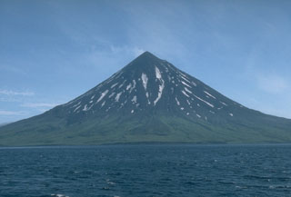
Geological Summary. The beautifully symmetrical Mount Cleveland stratovolcano is situated at the western end of the uninhabited Chuginadak Island. It lies SE across Carlisle Pass strait from Carlisle volcano and NE across Chuginadak Pass strait from Herbert volcano. Joined to the rest of Chuginadak Island by a low isthmus, Cleveland is the highest of the Islands of the Four Mountains group and is one of the most active of the Aleutian Islands. The native name, Chuginadak, refers to the Aleut goddess of fire, who was thought to reside on the volcano. Numerous large lava flows descend the steep-sided flanks. It is possible that some 18th-to-19th century eruptions attributed to Carlisle should be ascribed to Cleveland (Miller et al., 1998). In 1944 it produced the only known fatality from an Aleutian eruption. Recent eruptions have been characterized by short-lived explosive ash emissions, at times accompanied by lava fountaining and lava flows down the flanks.
Information Contacts: Alaska Volcano Observatory (AVO), a cooperative program of a) U.S. Geological Survey, 4200 University Drive, Anchorage, AK 99508-4667, USA (URL: http://www.avo.alaska.edu/), b) Geophysical Institute, University of Alaska, PO Box 757320, Fairbanks, AK 99775-7320, USA, and c) Alaska Division of Geological & Geophysical Surveys, 794 University Ave., Suite 200, Fairbanks, AK 99709, USA; USAToday (URL: http://www.usatoday.com).